Where is Bucks County, Pennsylvania?
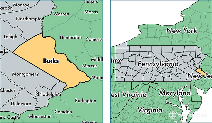
Bucks County is a county equivalent area found in Pennsylvania, USA. The county government of Bucks is found in the county seat of Doylestown.
With a total 1,610.65 sq. km of land and water area, Bucks County, Pennsylvania is the 1664th largest county equivalent area in the United States. Home to 626,685 people, Bucks County has a total 245827 households earning 76555 on average per year.
Bucks County, Pennsylvania offers the following attraction to visitors: Sesame Place
Bucks County, Pennsylvania - Quick Facts
| FIPS Code | 42017 |
| Area Codes | 610,215 |
| Time Zone | EST |
| Major Cities | Levittown (population: 64,221), Bensalem (population: 55,653), Morrisville (population: 51,482), Doylestown (population: 48,710), Warminster (population: 41,071), Southampton (population: 38,108), Langhorne (population: 35,157), Quakertown (population: 34,751), Newtown (population: 28,908), Feasterville Trevose (population: 26,040) |
| Land Area | 241,964 sq miles |
| Water Area | 604 sq miles |
| Household Income | $76,555 |
| Housing Units | 245,827 |
| Median Home Value | $309,900 |
| High School Grads | 93% of population |
| Holders of Bachelors Degrees | 36% of population |
| Retail Spending | $21,067 per capita |
| Food & Accomodation Sales | $970,247 per capita |
| Universities and Colleges | Bucks County Community College, Levittown Beauty Academy, Buck's County School of Beauty Culture Inc |
This page was last updated on June 30, 2016.