Where is Dona Ana County, New Mexico?
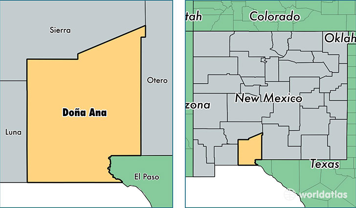
Dona Ana County is a county equivalent area found in New Mexico, USA. The county government of Dona Ana is found in the county seat of Las Cruces.
With a total 9,879.96 sq. km of land and water area, Dona Ana County, New Mexico is the 136th largest county equivalent area in the United States. Home to 213,676 people, Dona Ana County has a total 83133 households earning 37933 on average per year.
Dona Ana County, New Mexico offers the following attraction to visitors: Prehistoric Trackways NM
Dona Ana County, New Mexico - Quick Facts
| FIPS Code | 35013 |
| Area Codes | 575 |
| Time Zone | MST |
| Major Cities | Las Cruces (population: 147,481), Anthony (population: 18,879), Chaparral (population: 16,189), Sunland Park (population: 13,118), Santa Teresa (population: 5,890), La Mesa (population: 3,993), Mesquite (population: 3,958), Hatch (population: 3,385), Vado (population: 2,563), Mesilla Park (population: 2,015) |
| Land Area | 82,501 sq miles |
| Water Area | 3,808 sq miles |
| Household Income | $37,933 |
| Housing Units | 83,133 |
| Median Home Value | $139,100 |
| High School Grads | 78% of population |
| Holders of Bachelors Degrees | 27% of population |
| Retail Spending | $9,715 per capita |
| Food & Accomodation Sales | $238,748 per capita |
| Universities and Colleges | New Mexico State University-Main Campus |
This page was last updated on June 30, 2016.