Countries That Are Enclaves
- An enclave country is a country whose territory is completely surrounded by the territory of one other country.
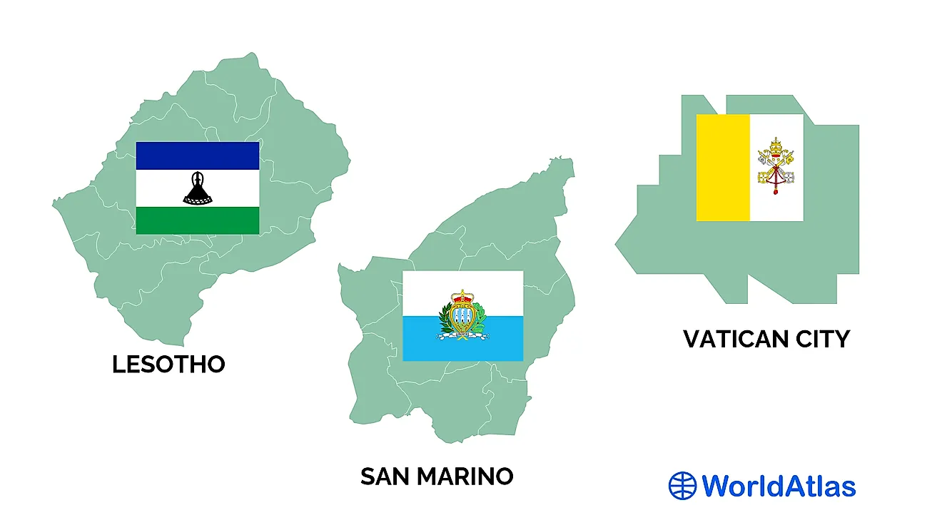
- There are just 3 enclave countries in the world: Lesotho, San Marino, and Vatican City.
- Both San Marino and Vatican City are in Europe, and are surrounded by territory belonging to Italy.
- Lesotho is the largest enclave country, while Vatican City is the smallest.
- Lesotho, located in Southern Africa, is surrounded entirely by territory belonging to the country of South Africa.
An enclave is a country that is completely surrounded by the territory of one other country. There are only three countries in the entire world that fit the definition of an enclave. Two of them, Vatican City and San Marino, are located in Europe, while the third, Lesotho, is located in Africa.
Lesotho is the largest enclave, while Vatican City is the smallest. Both Vatican City and San Marino are surrounded by territory belonging to Italy. Lesotho is surrounded by land belonging to South Africa.
Lesotho

Lesotho, officially known as the Kingdom of Lesotho, is a country in the African subregion of Southern Africa. It is surrounded entirely by territory belonging to South Africa, and is the largest of the world’s three enclave countries. Lesotho is the nation-state of the Basotho people. The Basotho nation was formed under King Moshoeshoe just prior to contact with Europeans, which first occurred in 1833.
In the mid-19th century, territorial incursions onto Basotho territory by Dutch colonists persuaded King Moshoeshoe to form an alliance with the British Cape Colony. In 1868, the territory of the Basotho nation, became the British protectorate of Basutoland. Although Basutoland was annexed to the Cape colony, it retained its autonomy as a High Commission Territory. In 1959, Basutoland became a British colony. Seven years later, it became a fully-independent country, and its name was changed from Basutoland to Lesotho, which literally translates as land of the Sotho.

Unlike most countries in Africa, Lesotho maintains a largely homogenous population in terms of ethnicity. About 99.7% of people in the country identify themselves as Basotho, though there are several subgroups of Basotho, including the Batloung (Tlou), Bakuena (Kuena), Baphuthi (Phuti), Bataung (Tau), Batsoeneng (Tsoene), Matebele, and Bafokeng. Sesotho is the main language spoken in the country, though English also has official status. About 90% of Lesotho’s people are Christian. The remaining 10% are followers of Islam, Hinduism, Bahaism, and indigenous religions. Lesotho has a total population of more than 2.1 million.
Lesotho is a poor, largely agrarian country. The country’s GDP per capita is just $1,088, and only 25% of the country’s people live in urban areas. Lesotho does, however, have a literacy rate of 85%, which is one of the highest rates on the African continent. The country is governed as a democratic constitutional monarchy, with the king as the head of state, and a prime minister as the head of the government. Lesotho has a bicameral legislature, with an upper house composed of hereditary chiefs and appointees of the king, and a lower house elected by the people.
San Marino

San Marino is an enclave country surrounded entirely by the territory of Italy. It is located in Italy’s northeast, close to the Adriatic Sea. San Marino is the world’s oldest republic. According to tradition, it was founded in 301 CE by Marinus, a Christian stonemason seeking refuge from religious persecution on Mt. Titano. San Marino was never part of any larger state, and has always been governed separately. It was a neutral country during World War II, and took in about 100,000 Italian refugees during the war. In 1992, the country became a member of the United Nations.
San Marino is tiny. It has a land area of just 61 sq. km, making it the 5th smallest country on Earth. The people of San Marino, who are called San Marinese, number only 33,860, making the country the 5th least populous country in the world. Being completely surrounded by Italy, it is no surprise that Italian is the official language of San Marino. San Marino’s main economic activity is tourism. Before the onset of the COVID-19 pandemic, the country welcomed about 3 million tourists per year.

San Marino has a parliamentary form of government with a unique system for determining its heads of state. Indeed, San Marino is one of only two countries that have two heads of state (Andorra is the other), known as the captains-regents, who are elected by the country’s legislature for terms of just six months. The legislature of San Marino, called the Great and General Council, is composed of 60 members, who are elected by the people to five-year terms. The Great and General Council also elects the 10-member Congress of State, which serves as government’s executive branch.
Vatican City

Vatican City, also called the Vatican, is the smallest of the three enclave countries. In fact, it is the smallest country in the world. Its land area is just 49 hectares. It is also the least populous country in the world, with a population of only 800 to 900 people, most of them priests and nuns from abroad. Like San Marino, the Vatican is entirely surrounded by territory belonging to Italy. Actually, Vatican City is surrounded by one Italian city, Rome, which is the capital of Italy.
The Vatican is best known as the seat of the Roman Catholic Church, which has an estimated 1.285 billion followers spread throughout the world, making it the largest Christian denomination on Earth. The Pope, who is the head of the Catholic Church, lives in the Vatican. Vatican City began its history as the seat of the Catholic Church in the 4th century CE, when a basilica was built over the grave of St. Peter, henceforth known as St. Peter’s Basilica.

For a short time, the Catholic Church abandoned the Vatican in 1309, moving its seat of power and the papacy to Avignon, France. In 1377, however, the Catholic Church returned to the Vatican and worked to restore its buildings, which had fallen into disrepair while the Church was headquartered in Avignon. Work on the famous Sistine Chapel began in the 1470s. Subsequently, the famous artist, Michelangelo, was charged with painting the Chapel’s ceiling in 1508.
Prior to 1870, Popes residing in the Vatican ruled over territory known as the Papal States. But in 1870, the government of Italy claimed the territory of the Papal States, other than the Vatican, for itself. This was the beginning of a dispute that would last nearly 60 years, until the government of Italy and the Vatican concluded an agreement known as the Lateran Treaty in 1929, by which the Vatican was recognized as a sovereign entity.