Alappuzha, India
Formerly referred to as Alleppey, Alappuzha is a city and municipality situated on the southwestern coast of India in the State of Kerala. The name Alappuzha is a toponym, where the word ‘Alayam’ means ‘home’ and ‘puzha’ means ‘river’ and refers to “the land between the sea and the network of rivers flowing into it.” Nicknamed as “Alleppey, the Venice of the East” by Lord Curzon, the then Viceroy of India, Alappuzha is one of India’s most popular tourist destinations that is most well-known for its backwaters, beaches, canals, and lagoons, attracting millions of local as well as international tourists.
Geography Of Alappuzha

Alappuzha is situated on a narrow land spit between the Arabian Sea and the Vembanad Lake. The city covers an area of 46.20 sq. km and is located approximately 62km south of Kochi and 155km north of Thiruvananthapuram – the capital of the Indian State of Kerala. The city serves as the administrative headquarters of the Alappuzha District, which covers an area of 1,414 sq. km and comprises six taluks: Ambalappuzha, Cherthala, Chengannur, Karthikappally, Kuttanad, and Mavelikkara. The Alappuzha district is surrounded by the Laccadive Sea in the west; the Ernakulam district’s Kochi and Kanayannur taluks in the north; the Kollam district’s Kunnathur and Karunagappally taluks in the south; the Kottayam district’s Changanassery, Vaikom, and Kottayam taluks, and the Pathanamthitta district’s Thiruvalla and Kozhencherry taluks in the east.
The Alappuzha district is a sandy strip of land crisscrossed by a network of canals, rivers, and lagoons. Other than a few scattered hillocks, there are no mountains or hills in the district. It is also the only district in Kerala with no high land and forest area. A principal feature of the region is Kuttanad, which is referred to as the ‘rice bowl of Kerala’ and is also India’s lowest point, situated at an elevation of 2m below sea level.
Transportation In Alappuzha

The city of Alappuzha is well connected by roadways, railways, and aviation facilities with the other major cities of India. The 1,608km long National Highway 66 passes through the center of Alappuzha, connecting it with major Indian cities like Kozhikode, Kollam, Kannur, Mangalore, Ernakulam, Udupi, Thiruvananthapuram, and Mumbai. Several State Highways, including State Highway 11 and State Highway 40, also pass through the Alappuzha district. The network of canals and backwaters in Alappuzha form a part of the National Waterway-3 and serves as one of the popular means of transportation. The Ernakulam-Kayamkulam coastal railway line connects Alappuzha with the other cities of India. Located at a distance of 82.8km from Alappuzha, the Cochin International Airport is the nearest airport. Alappuzha also serves as an access point for the Nehru Trophy Boat Race, which is considered one of India’s most popular and competitive boat races, held every year on the large Vembanad Lake.
Climate
The climate of Alappuzha is significantly moderated due to its closeness to the sea. It experiences a hot and humid climate during the summers and is cool and pleasant during the winters. The average monthly temperature is about 27°C. The Alappuzha district experiences a long monsoon season and receives heavy showers from the two seasonal monsoons – the Southwest monsoon from June to September and the Northeast monsoon from October to November. The district receives an average rainfall of 2763mm. An interesting phenomenon that takes place during June in the flat, 82km long unbroken seacoast of Alappuzha, is “Chakara” - the periodic shifting of mud bank within a range of 25km in the Alappuzha-Purakkad coast. This occurs due to the generation of hydraulic pressure that leads to a rise in the level of backwaters during the southwest monsoon.
The Population And Economy Of Alappuzha

As per the 2011 census, the Alappuzha district is home to 21,21,943 people, of which are 11,11,691 females and 10,10,252 are males, with a sex ratio of 1100 females per 1000 males. Alappuzha has a population density of 1492 persons per sq. km. The literacy rate of Alappuzha is 96.26%. About 49.85% of Alappuzha’s population are followers of Hinduism, 26.23% are followers of Christianity, 23.62% are followers of Islam, and 0.30% are followers of other religions. The most widely spoken languages in Alappuzha include Malayalam and Konkani.
The economy of the Alappuzha District is mainly driven by agriculture, the manufacture of marine products, and tourism. Some of the essential products manufactured here include coir and coir products, copra, coconut oil, mats, matches, different types of handicrafts, and marine products. Moreover, the availability of raw materials and a network of canals and backwaters that aid in transportation has significantly helped in the development of industries in this region.
Tourist Attractions In And Around Alappuzha
Alappuzha Backwaters

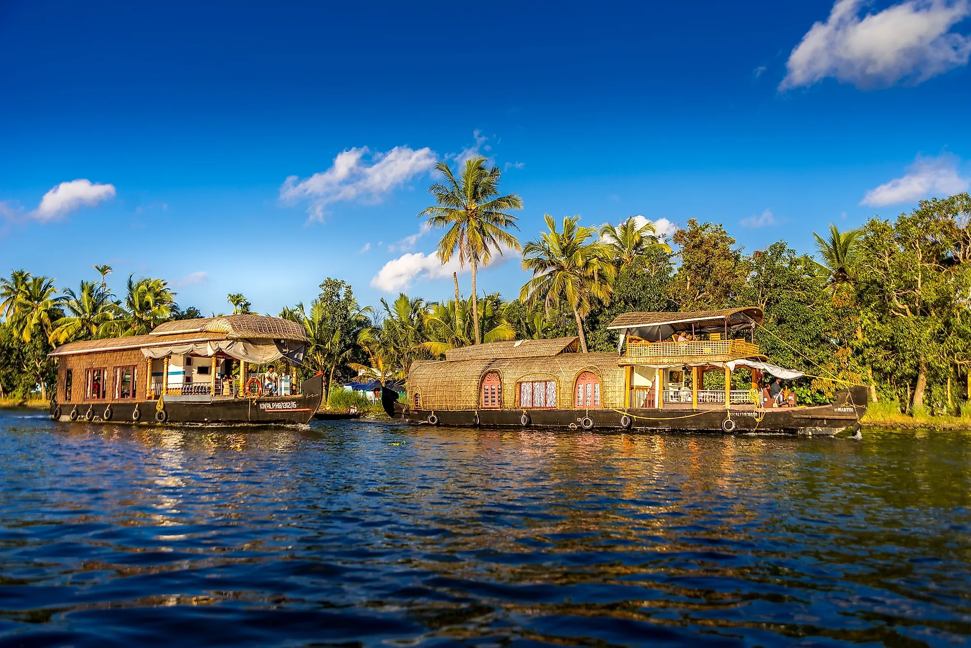
The Alappuzha backwaters are Kerala’s most popular tourist attractions that attract millions of local and international tourists. The backwaters are an interconnected network of lakes and brackish lagoons situated parallel to the state’s Arabian Sea coast. The backwaters host several important animal species, including ducks, cormorants, common teal, crabs, mudskippers, kingfishers, etc. At present, more than 2000 houseboats that are locally referred to as “ketuvallams” provide the tourists with scenic views of the backwaters.
Kumarakom Bird Sanctuary
Spread over an area of 0.05 sq. km, the Kumarakom Bird Sanctuary is situated on the shores of Vembanad Lake in Kottayam. The Kumarakom Bird Sanctuary serves as a popular destination for birdwatching as many migratory birds from far-ranging places like Siberia, and the Himalayas flock here in large numbers. Some of the notable avian species found here include waterfowl, cormorant, brahminy kite, tern, flycatchers, cuckoos, etc.
St. Mary Forane Church

Also referred to as Champakulam Kalloorkadu St. Mary’s Basilica, St. Mary Forane Church, located on the banks of the River Pamba in Alappuzha district, is one of the oldest Syrian Catholic Churches in India. The brilliant architecture of the church is a beautiful amalgamation of various elements from the Portuguese and Syrian Christian cultures. St. Mary Forane Church was officially declared as a basilica on November 27, 2016, and became India’s 23rd basilica and the 1st basilica in the archdiocese of Changanasserry.
Alappuzha Beach

Alappuzha Beach is one of the most popular tourist spots in Alappuzha. The Beach contains an old pier which is believed to be more than 150 years old. The Alappuzha Beach serves as a venue for several annual events, including the Alappuzha beach festival, the international sand art festival, etc. Also located close to Alappuzha Beach is the Alappuzha Lighthouse, which is considered the first of its kind on the Arabian Sea coast of the State.
Krishnapuram Palace

The Krishnapuram Palace is a palace and museum located in Kayamkulam in the Alappuzha district, about 47km away from Alappuzha. The palace is one of the finest examples of a typical Kerala style of architecture filled with gabled roofs, dormer windows, and narrow corridors. The Krishnapuram Palace is a protected monument maintained by the Kerala State Department of Archaeology and houses exhibits belonging to Maharaja Marthanda Verma of Travancore.
Brief History Of Alappuzha

As per several historical sources, the Kuttanad region was well known from the early Sangam Age with its unending stretch of paddy fields and green coconut palms. From the 9th to 12th century AD, the district flourished remarkably under the rule of the second Chera Empire. The present town of Alappuzha owes its existence to Raja Kesava Das, the wise Dewan of Travancore. To develop Alappuzha into a commercial center, the Dewan brought many business people from all over the country to the town. Several canals were opened to transport goods and spices, and in due course, Alappuzha soon became a trading center for various products like coir, copra, ginger, cardamom, rubber, etc. The Alappuzha district also played a prominent role during India’s freedom struggle. After Indian Independence, the State of Kerala was formed as per the States Reorganization Act on November 1, 1956. On August 17, 1957, the Alappuzha district was carved out from the former Kottayam and Quilon districts and became a separate administrative unit.