11 Of The Most Captivating Small Towns In California's Sierra Nevada
The Sierra Nevada is best understood in the margins places where a caldera still steams in winter, where a courthouse from 1854 still tries cases, where a hardware store has sold hinges since the Gold Rush.
These 11 towns aren’t waypoints between national parks; they are the operating system of the Sierra small, specific, stubbornly local and they reward attention at street level.
Truckee

Truckee’s character is defined by its bones historic brick buildings, old railroad ties, and a rawness that hasn't been polished out by tourism. Once a key hub for the Central Pacific Railroad and the transcontinental Lincoln Highway, this town has a working memory of movement and migration. Its winters are brutal; its summers are dry and electric. The Donner Party's story is stitched into its origin, and yet Truckee has refused to be reduced to a footnote in westward expansion. Instead, it’s a living archive of high-altitude resilience, backed by jagged peaks and cut through by the Truckee River.
Downtown, the Truckee Railroad Museum inside a tiny caboose tells the town’s industrial past in tight, compelling detail. Across the street, Coffeebar roasts its own beans and fills with locals by 7 a.m., working remotely or reading paperbacks. Donner Memorial State Park offers shaded trails and a sobering monument to the families who perished just west of here. On the north edge of town, the Cottonwood Restaurant & Bar occupies a former ski lodge from 1928 its wood walls creak with age, and its balcony stares directly at the lights of downtown and the slow curve of the Sierra crest.
South Lake Tahoe

South Lake Tahoe sits on a fault line not just geologically, but culturally. It’s a collision point between alpine wilderness and casino neon, between California’s environmental ethos and Nevada’s loosened grip. At 6,200 feet, the air is thin, and the contrasts sharper. On the south shore, there's a phenomenon known as Tahoe Blue, a particular hue that appears just after sunrise in winter when the lake surface mirrors the ice-packed sky. This is not a resort town trying to be charming; it’s a place shaped by snowmelt, state lines, and economic survival.
Regan Beach offers a quieter shoreline with views stretching across to Mount Tallac more sedate than tourist-heavy Pope Beach to the west. The Tahoe Art League Gallery on Highway 50 rotates work from regional artists, much of it focused on lake light, granite, and fire. In the evenings, The Idle Hour pours by-the-glass wines in a two-story lakefront space with a cold, unfiltered view of the water. The surrounding forest is always close, just beyond the edges of light, anchoring the town in something older than tourism.
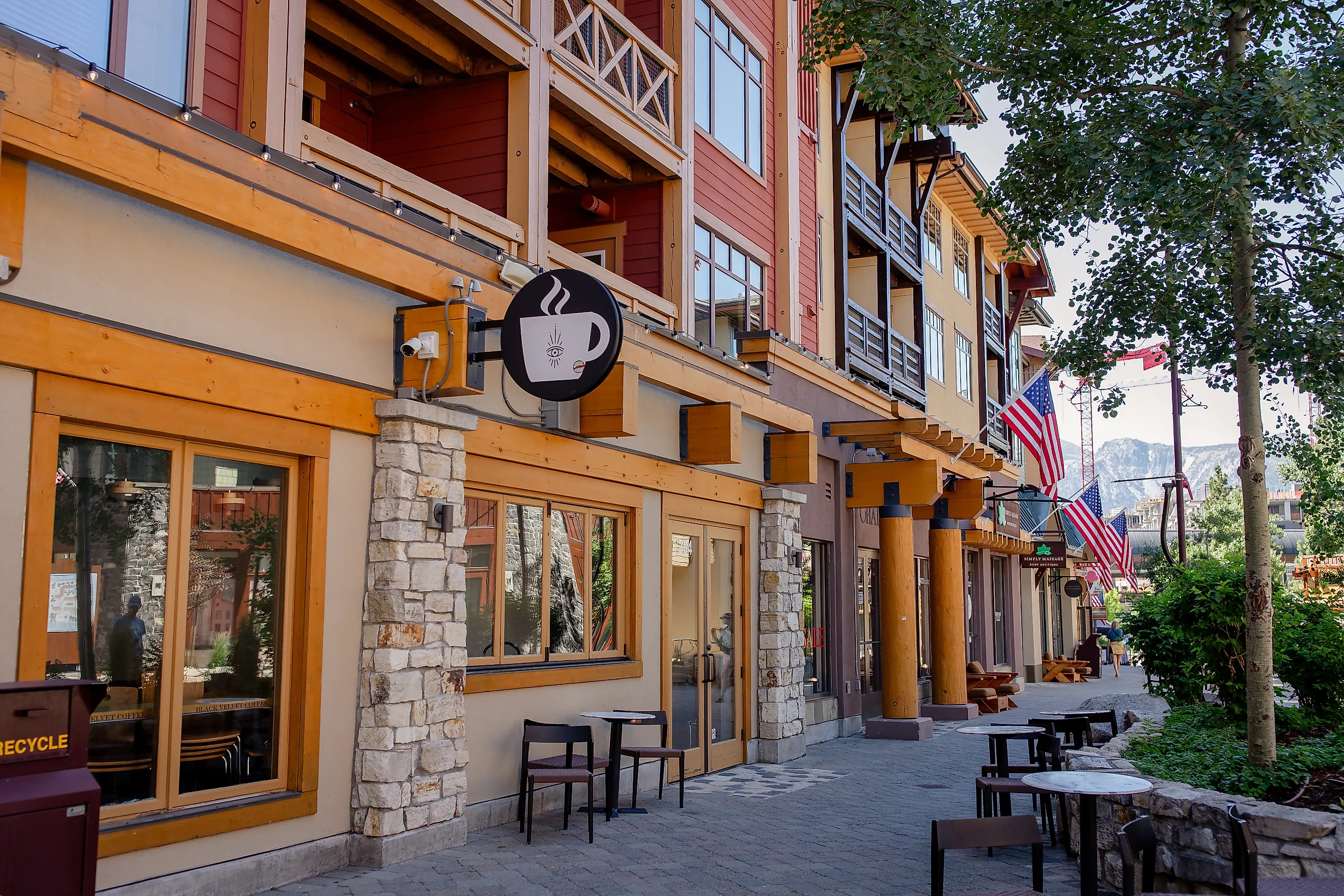
Mammoth Lakes

Mammoth Lakes is built on a collapsed volcano. Its floor still shifts; its ridges steam after snow. The town sits inside the Long Valley Caldera, one of the largest active volcanic systems in North America, and its terrain reflects that instability cracked lava domes, boiling springs, sulfur flats. At over 7,800 feet, this is not a gateway town; it is an endpoint. Winds howl off the Sierra crest. Bears cross parking lots at dusk. The geology isn’t a backdrop it’s the stage.
The Mammoth Museum at the Hayden Cabin offers a compact record of settlement, mining, and early tourism, set beside Mammoth Creek. Black Velvet Coffee roasts in small batches and operates with a laboratory-like precision; their espresso bar overlooks a quiet industrial park near the airport. The Devil’s Postpile formation, a short drive away, remains one of California’s rare examples of columnar basalt, its symmetrical rock stacks rising like organ pipes.
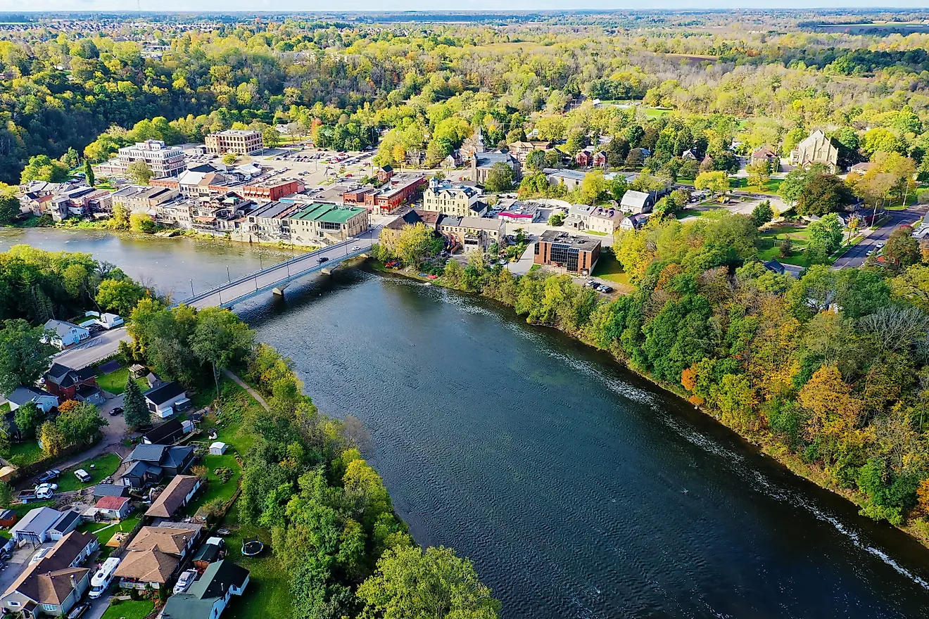
Nevada City

Nevada City was wired for electricity before San Francisco. It ran arc lights powered by water-driven turbines fed from the South Yuba River. That same river still defines the town, coursing beneath moss-covered footbridges and shaping the granite canyons just outside the historic core. At just over 2,500 feet, Nevada City clings to the edge of the Sierra foothills high enough for snow, low enough for fog. Its streets follow no grid; they wind with the contours of 19th-century mining ambitions and a refusal to flatten the land.
The Nevada Theatre, built in 1865, remains California’s oldest operating theater and regularly stages performances by local companies like LeGacy Productions. The Firehouse No. 1 Museum displays Gold Rush-era firefighting equipment, maps, and records inside a converted 1861 brick station. On the edge of town, the Inn Town Campground offers canvas tents among madrone and pine, within walking distance of downtown.
Grass Valley

Grass Valley holds the distinction of being home to the most productive hard rock gold mine in California history. The Empire Mine yielded over 5.8 million ounces before shutting down in 1956. The Cornish miners who came to work it brought with them a distinct dialect, meat pasties, and the blueprints for steam-powered engineering still visible in the area’s industrial relics. Grass Valley’s elevation sits just above the fog line and below the winter freeze, making its climate oddly temperate compared to neighboring Sierra towns.
Empire Mine State Historic Park remains the most intact site of its kind in the state, with preserved headframes, gardens, and blacksmith demos operating seasonally. The Center for the Arts on Main Street books touring musicians, spoken word, and visual art installations in a converted former newspaper building. Carolines Coffee Roasters has operated downtown since 1982, roasting in-house and serving coffee alongside molasses cookies made from a family recipe. At night, Sergio’s Caffé fills quickly with locals its limited Italian menu rarely changes and includes a house gnocchi that often sells out by 8.
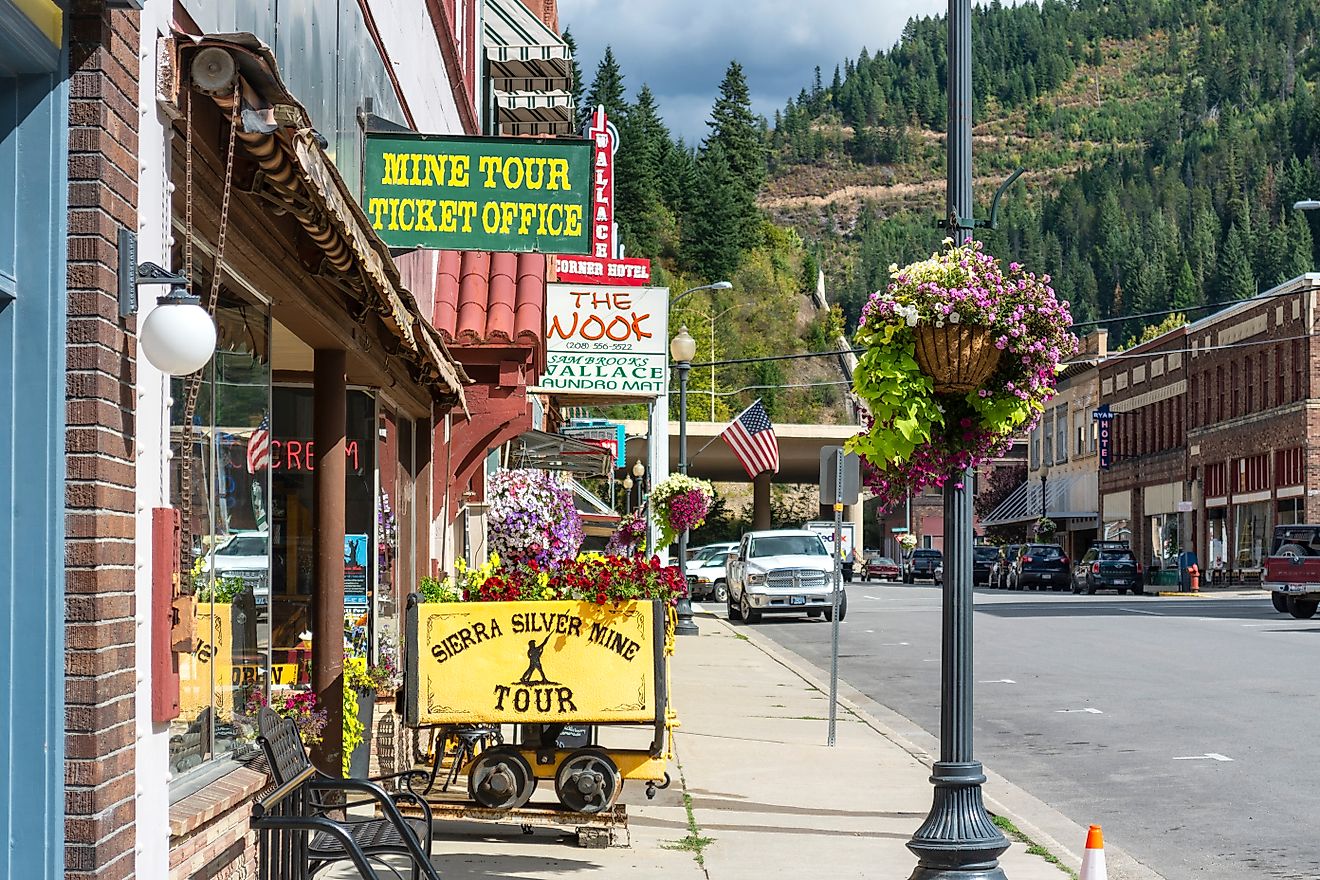
Placerville

Placerville earned the name “Hangtown” for its swift frontier justice in the 1840s its gallows once stood near the corner of Main and Coloma. Though the noose is gone, the past remains visible in iron hitching rings embedded in the sidewalks and in the gold dust occasionally stirred up in creek beds after storms. Placerville was a supply hub for miners heading to Coloma, just ten miles north, and its irregular street plan still reflects the patterns of mule trails and wagon ruts.
The Placerville Hardware Store, operating since 1852, sells cast iron fittings and bee boxes from the same creaky wooden floorboards that once bore gold scales. Powell’s Steamer Co. & Pub, tucked near Cedar Ravine, serves pints with fish and chips to a crowd that includes off-duty firefighters and orchard workers. The El Dorado County Historical Museum, just off Forni Road, houses gold pans, mining records, and a preserved narrow-gauge railcar used for logging. Further up Canal Street, Sweetie Pie’s Bakery bakes cinnamon rolls in a converted Victorian and opens before dawn to serve locals heading into the mountains.
Sonora

Sonora was settled by Mexican miners from Sonora, Mexico in 1848, giving the town a name and character distinct from the Anglo-dominated Gold Rush corridor. It became a legal battleground for land rights after California statehood, with conflicts between original Mexican settlers and incoming speculators shaping its early laws and boundaries. Tucked in a bowl of dry hills and granite outcrops, Sonora sits just above 1,700 feet, where foothill oaks give way to incense cedar and digger pine.
The Tuolumne County Museum operates inside a former jail, complete with cellblocks and ledger books recording arrests for horse theft and claim jumping. Just north of town, Indigeny Reserve sits in an apple orchard and produces hard cider, brandy, and vinegar tastings are held in a barn overlooking the creek. Sonora’s past has not been rebranded or polished out.
Murphys

Murphys was once known as the “Queen of the Sierra,” a title it earned in the 1850s when its gold deposits drew more than 3,000 miners into a single canyon less than a mile wide. By 1859, more than $20 million in gold had been pulled from the surrounding creeks and hillsides. Mark Twain visited in the 1860s and lodged nearby while researching local stories that would become part of Roughing It. The town sits in a dry belt between oak woodland and the first rise of red fir, and its Main Street runs along a fault line once mapped by Clarence King himself.
The Murphys Historic Hotel still houses guests in rooms with original brick walls and iron bedsteads Ulysses S. Grant once stayed here. Across the street, Alchemy Café plates duck confit and mushroom risotto, and stocks Calaveras County wines. The Ironstone Heritage Museum, part of Ironstone Vineyards, exhibits gold nuggets, mining tools, and a fully restored 19th-century pipe organ. Downhill from the center of town, Murphys Community Park offers river access, a bandstand, and picnic tables shaded by valley oaks.
Mariposa

Mariposa was the southernmost county in California when the state was formed in 1850, stretching all the way to what’s now Los Angeles. Its original land grants once encompassed nearly a fifth of California, but the town itself remained concentrated along a single creek-fed corridor at the base of the Sierra. John C. Frémont owned much of it at one point, using his mining claims to fund expeditions and political campaigns. The town’s courthouse, built in 1854, is the oldest still in use west of the Rockies and was constructed entirely with hand-forged nails.
The Mariposa Museum & History Center preserves Chinese immigrant tools, assay records, and Frémont’s military maps inside a low, whitewashed complex just off Highway 140. Pony Expresso, on the east end of town, serves house-roasted coffee and stocks fresh almond biscotti from Oakdale. The Hideout Saloon, a subterranean bar with stone walls and iron chandeliers, hosts bluegrass nights and pours local cider from Sierra Cider Company. At the top of Fifth Street, the Mariposa Creek Parkway winds past old mill sites and riparian willows, connecting the library to the southern edge of town.
Oakhurst

Oakhurst was once known as Fresno Flats, a supply stop along the stagecoach route to Yosemite in the 1870s. Its claim to modern fame is unexpected it was the original home of Sierra On-Line, the video game company that helped define the PC gaming industry from a two-story log cabin off Highway 41. The town sits at the junction of two forks of the Fresno River, where granite foothills give way to cedar thickets and manzanita-covered slopes. The population swells in summer but thins again by the first frost.
The Fresno Flats Historic Village preserves schoolhouses, blacksmith shops, and clapboard cabins moved from nearby logging camps, arranged across shaded acreage just west of the highway. South Gate Brewing Company, built on the site of an old lumberyard, brews ales using Sierra snowmelt and serves pork belly tacos to a crowd that includes trail crews and retired rangers. At Reimer’s Candies and Gifts, machines from the 1950s still churn out fudge and ice cream behind glass windows.
Bishop

Bishop is not technically in the Sierra Nevada it sits in the Owens Valley, between the Sierra crest and the White Mountains but no other town is as tethered to the eastern slope. It’s the only incorporated city in Inyo County and acts as a last major stop before the long stretch of U.S. 395 that climbs into desert or granite, depending on direction. In the 1920s, Los Angeles quietly acquired water rights to the Owens River and drained much of the valley to feed a growing metropolis. The fallout is still visible: dry lakebeds, diverted creeks, a history museum that doesn’t flinch.
The Laws Railroad Museum and Historic Site, 6 miles north, holds 11 acres of preserved depot buildings and track, including narrow-gauge engines and telegraph equipment. Great Basin Bakery on Main Street bakes multigrain bread with rye flour sourced from Nevada and rotates through seasonal hand pies. Keough’s Hot Springs, south of town, operates year-round and channels geothermal water into a 100-foot-long pool built in 1919.
Threaded along granite and river, these towns are not detours but the Sierra’s working memory: rail beds turned museums, roads reimagined as main streets, vineyards where diggings once stood. Each place carries a claim, from oldest courthouse and historic theater to hot springs and lakeshore gallery, and keeps using it. Together they map a mountain culture that endures fire, snow, and boom-bust cycles, holding fast to craft, water, and history.