11 Most Peaceful Small Towns In California
California’s quiet has a map. It starts where the last billboard flickers out, cell bars thin to one, and the road trades palm trees for granite and cedar. Peace here isn’t a slogan or a spa package; it’s a pattern you can clock: a post office that shuts for lunch and a bakery that sells out of sourdough by noon and locks the door without apology.
This list traces that pattern across the state’s edges and elevations. The towns that follow clear a simple bar: water close by, trailheads within walking distance, and a main street that trades spectacle for routine. Expect coffee poured by the owner, beaches named by locals, and evening air you can hear. The noise isn’t gone; it’s edited, down to creeks, wind in pine, and the soft hydraulics of a rowboat drifting against a dock.
Mammoth Lakes

At nearly 8,000 feet in elevation, Mammoth Lakes sits beneath the eastern face of the Sierra Nevada in a glacial basin once carved by ice, now ringed by granite spires. The town is uniquely bracketed by ancient volcanic calderas to the east and snow-loaded alpine peaks to the west. The result is a landscape that reads as both wild and expansive, yet completely self-contained. Mammoth is one of the few towns in California where mule deer and hot springs share a zip code with skiers and climbers.

Start the day at Stellar Brew, a no-frills coffeehouse where climbers scribble route notes into notebooks between sips of espresso. From there, head up to Lake Mary or Twin Lakes, both reachable by road or foot, where the water stays mirror-still through early morning and pine shadows stretch long. A short drive leads to Hot Creek Geological Site: a steaming, geologically active gorge just south of town. At sundown, locals gather at the Mammoth Rock Trail viewpoint, where the Minarets turn black against a last pink sky. For dinner, Skadi serves alpine cuisine rooted in the terrain, roasted trout, red cabbage, house-pickled mountain vegetables. The town quiets by 9.
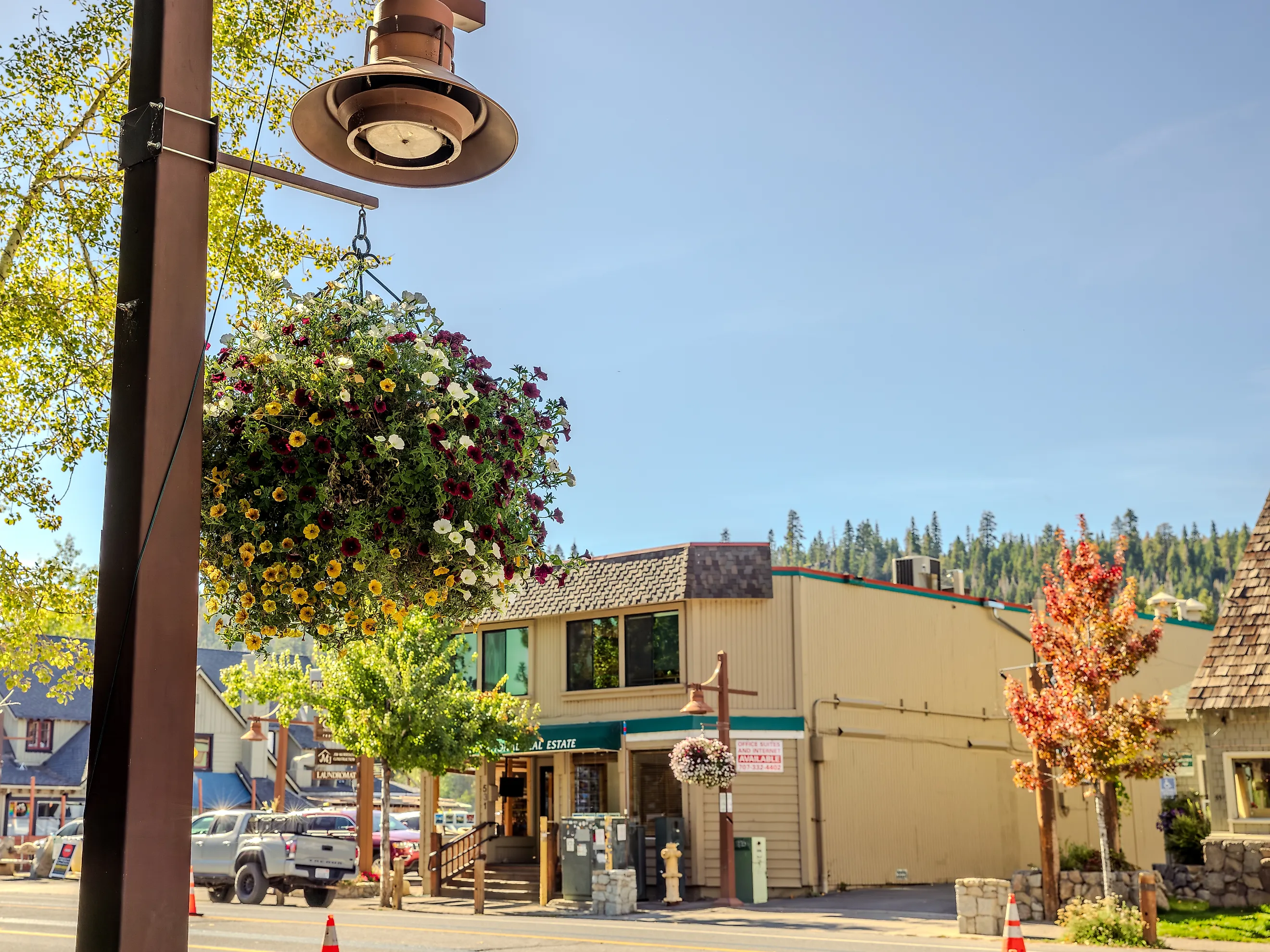
Truckee

Truckee sits just west of Donner Pass, where granite walls rise above pine-covered basins and freight trains echo across the valley. What makes this town unusual is that it’s deeply rooted in railroading history while maintaining a clean connection to the forested ridgelines surrounding it. The town’s name comes from a Paiute leader who greeted early settlers with the word “Tro-kay,” misheard as a name. Today, the original 19th-century buildings along Commercial Row remain mostly intact, stone, wood, and iron, preserved without ornament. The air smells like snowmelt and pitch pine.

The Truckee River Legacy Trail begins near Truckee Regional Park and traces the water east through quiet cottonwood groves. Along the river, Wild Cherries Coffee House offers a seat by the window with house-roasted beans and scratch-made granola. The Donner Memorial State Park Visitor Center documents the infamous Donner Party but does so quietly, with artifacts and a concrete obelisk that marks winter snow levels. At sundown, Donner Lake’s west shore is nearly empty, Cedar Point or Windy Point provide access without crowds. Moody’s Bistro, inside the historic Truckee Hotel, serves rye Manhattans and house-made pasta in a dim, unhurried dining room.
South Lake Tahoe

South Lake Tahoe occupies a narrow bowl between alpine peaks and the largest high-elevation lake in North America. Unlike towns that border the lake in passing, South Lake straddles the California-Nevada line and anchors the southern rim in full. What sets it apart is its tension: resort infrastructure fades quickly into empty shoreline and dense forest. The town absorbs silence easily. During early snowfall or late shoulder season, the streets are half-empty and the lake turns steel gray, drawing in light without sound.

On the southwest edge, Baldwin Beach faces Mount Tallac directly and stays quiet long after summer ends. The trail to Fallen Leaf Lake begins nearby and climbs gently through red fir and aspen. In town, Cuppa Tahoe serves delicious coffee. El Dorado Beach offers direct lake access without development, the walking path hugs the shoreline in both directions. In the evening, head uphill to the observation deck at Heavenly Mountain via the gondola; views stretch deep into Nevada. Basecamp Hotel’s beer garden hosts acoustic sets with heat lamps and string lights, but the mood is subdued.
Tahoe City

Tahoe City sits at the only outlet of Lake Tahoe, where the Truckee River begins its descent toward the high desert. A concrete dam built in 1913 still controls the lake’s level, but the water rushes clear beneath Fanny Bridge, named for the tourists who lean over its railings. The town’s scale is precise. One stoplight. A cluster of weathered wood buildings. Then open shoreline and cold water. What stands out is the density of natural access within town limits. There’s no need to drive. From anywhere downtown, forest, beach, and river lie within walking distance.

The Gatekeeper’s Museum, just west of the bridge, houses photographs and woven baskets from the region’s Washoe and early settler history. Behind it, a narrow trail leads to Lake Forest Beach, often empty, with volcanic rock outcrops and driftwood berms. Commons Beach anchors the town center, a wide lawn, small playground, and weekly farmer’s market in season. Nearby, Dam Café serves strong coffee and hard-boiled egg sandwiches out of a low stucco building with picnic tables. Across the road, Rosie’s Café still operates with its original 1940s soda fountain and a suspended canoe above the bar.
Big Bear Lake

Big Bear Lake occupies a high basin in the San Bernardino Mountains at just over 6,700 feet. Unlike most alpine lakes in California, it’s manmade, originally dammed in 1884 for irrigation. But what stands out is how the town hugs the shoreline in a full circle, interrupted only by forest. The lake acts as both compass and quiet buffer. Boats drift without sound in the coves. By October, the water temperature drops below 60°F, and the pace of the town slows. The roads stay open. Pine needles collect in the bike lanes.

The Alpine Pedal Path begins near the Solar Observatory and runs east toward Stanfield Marsh Wildlife Area. Mornings bring still water and long stretches of silence. At noon, lunch at Grizzly Manor Café comes fast, thin pancakes, chipped mugs, and no music. The dining room seats twenty. Nearby, Castle Rock Trail gains just 700 feet in under a mile but ends at a granite bluff with lake-wide views. In the evenings, the marina closes early.
Lake Arrowhead

Lake Arrowhead was once called “Little Bear Valley” until the early 1900s, when private developers renamed it to attract Los Angeles investors. The lake itself is private, owned by residents, but its mirrored surface still defines the visual and emotional rhythm of the town. Everything bends toward it. The surrounding San Bernardino National Forest wraps the settlement in uniform height and shadow. The main village was built in the 1920s in an Alpine Tudor style, and the architecture remains largely unchanged.

Heaps Peak Arboretum offers a flat, one-mile loop through incense cedar and black oak. The trail is marked by hand-painted signs and carved benches. In the village, Belgian Waffle Works serves breakfast all day from a dockside patio facing the marina; trout and herons move beneath the pilings. Lake Arrowhead Queen runs narrated boat tours that circle the perimeter of the lake’s private coves and glassy backwaters. Just beyond town, Heart Rock Trail in Crestline ends at a carved stone basin shaped like a near-perfect heart, naturally formed by centuries of runoff.
June Lake

June Lake sits in a glacially carved loop beneath the north face of Carson Peak, a steep granite wall that traps weather and reflects early light. The town, with fewer than 700 residents, runs along a single main road, beyond it lies silence, lodgepole pine, and four lakes in close succession. The loop is closed in winter, sometimes for months, cutting the area off from through traffic. June Lake remains one of the few Eastern Sierra towns without a traffic signal, chain restaurant, or commercial marina development.

At the edge of town, June Lake Brewing pours cold IPA into mason jars beside a food truck that serves fried Brussels sprouts and charred fish tacos. The seating is open-air, shared with pine beetles and wind. Gull Lake Park is a block downhill, a few picnic tables, a playground, and boat rentals operated from a wooden shed. The Parker Lake Trail begins just up the road; it follows a glacial creek through aspen and alder before opening to a clear lake beneath Mount Wood. Trout are visible from shore. The June Lake General Store sells cheese, fly line, and aspirin from a narrow counter behind the register.
Bishop

Bishop sits in the Owens Valley between the Sierra Nevada and the White Mountains. Its elevation is low, just above 4,000 feet, but it’s flanked by peaks that rise more than 10,000 feet above town. This contrast defines the region: a dry, high desert floor backed by granite walls and snowmelt-fed creeks. The town was originally a ranching settlement, not a resort, and its layout still follows irrigation canals and cattle paths. There are no gated communities or shoreline developments. The pace is flat, with distance visible in every direction.

Great Basin Bakery serves handmade breads, giant cookies, breakfast burritos, and strong coffee, fueling early anglers and climbers. Just west, Bishop Creek Canyon holds three alpine lakes, Sabrina, North, and South, each reachable by car, all surrounded by glacial basins and trailheads. At Laws Railroad Museum, a preserved 1880s depot includes original buildings, mining equipment, and telegraph lines that still hum in the wind. In town, Looney Bean Coffee backs up to the Owens River Canal and serves iced coffee in silence before sunrise. Between May and September, anglers stand in waders behind the airport, casting over cutthroat trout in the Bishop Reservoir.
Mount Shasta

Mount Shasta rises over 14,000 feet but casts its longest shadow across a town of fewer than 3,500 people. What defines Mount Shasta as a place is its vertical presence: the volcano appears suddenly and completely, unbuffered by foothills. The mountain is active but hasn’t erupted in centuries. Local geology reads like a timeline of ancient lava flows and glacial recession. The town sits at 3,600 feet, with snow visible nearly year-round. Main Street is one block long, built low to the ground. There is no skyline. The mountain takes that role.

At the southern edge of town, Mount Shasta City Park contains the headwaters of the Sacramento River. The water comes out of the ground clear, cold, and fast, channeled immediately into a small creek with a short footbridge. Berryvale Café serves lentil stew and grain bowls beside a small grocery that stocks bulk herbs and local honey. Just west of town, Lake Siskiyou reflects the full east face of Shasta from a narrow dam or the loop trail that circles its shoreline. On North Mt. Shasta Boulevard, Seven Suns Coffee offers espresso and soft-boiled egg plates on a small patio facing the street.
Dunsmuir

Dunsmuir sits in a narrow river canyon beneath Castle Crags and the southern slope of Mount Shasta. Once a major railroad stop on the Southern Pacific line, the town still orients around its tracks. Freight cars pass at low speed, often the only sound in the early hours. The downtown buildings, mostly brick, two stories, built before 1940, line a curved section of road just above the Upper Sacramento River. The water runs fast and cold even in August. Elevation: 2,300 feet. The town faces north and stays cool.

Hedge Creek Falls is a short trailhead just off I-5 that ends behind a 30-foot cascade and opens to a vista of the canyon below. Tauhindauli Park sits beside the river and includes restored wetlands and interpretive paths that follow the contours of the original rail grade. YAKS on the 5 serves espresso and garlic-crusted burgers beneath a wooden mezzanine that overlooks the freeway, trucks pass, but the building stays quiet. The Dunsmuir Botanical Gardens in the city park hold native dogwood, cedar, and shaded picnic tables near a steel footbridge.
Shaver Lake

Shaver Lake was built to serve a hydroelectric project in 1927, but the reservoir now supports a town with no chain stores, no stoplights, and no natural shoreline development. At 5,500 feet, the waterline is ringed by granite slabs and red fir. The lake is owned by Southern California Edison, and the surrounding land is a patchwork of forest service leases and old logging routes. What stands out is the layout: cabins spaced far apart, businesses set back from the road, and long stretches of silence between signs of movement. The reservoir fluctuates with snowmelt and power demand. The drawdowns leave smooth stone beaches.

The trail to Rancheria Falls begins just north of the marina and follows a shallow creek through wildflowers and shade. The falls drop in steps across granite shelves, with shallow pools at the base. Shaver Lake Pizza is a family-run restaurant across from the gas station; it serves pepperoni and Canadian bacon on steel pans under knotty pine rafters. Hungry Hut, closer to the water, opens before lunch and closes when the rush dies out. Nearby, McKinley Grove holds a dense stand of giant sequoias.
Peace in California isn’t rare; it’s specific. It lives where the map thins, where water sits within walking distance and main streets keep regular hours. These towns trade spectacle for habit: coffee poured by the owner, trailheads at the edge of the sidewalk, night skies that start on time. Pick any of them and you get the same dividend, unhurried mornings, audible creeks, and the relief of being nowhere in particular.