Niagara Falls
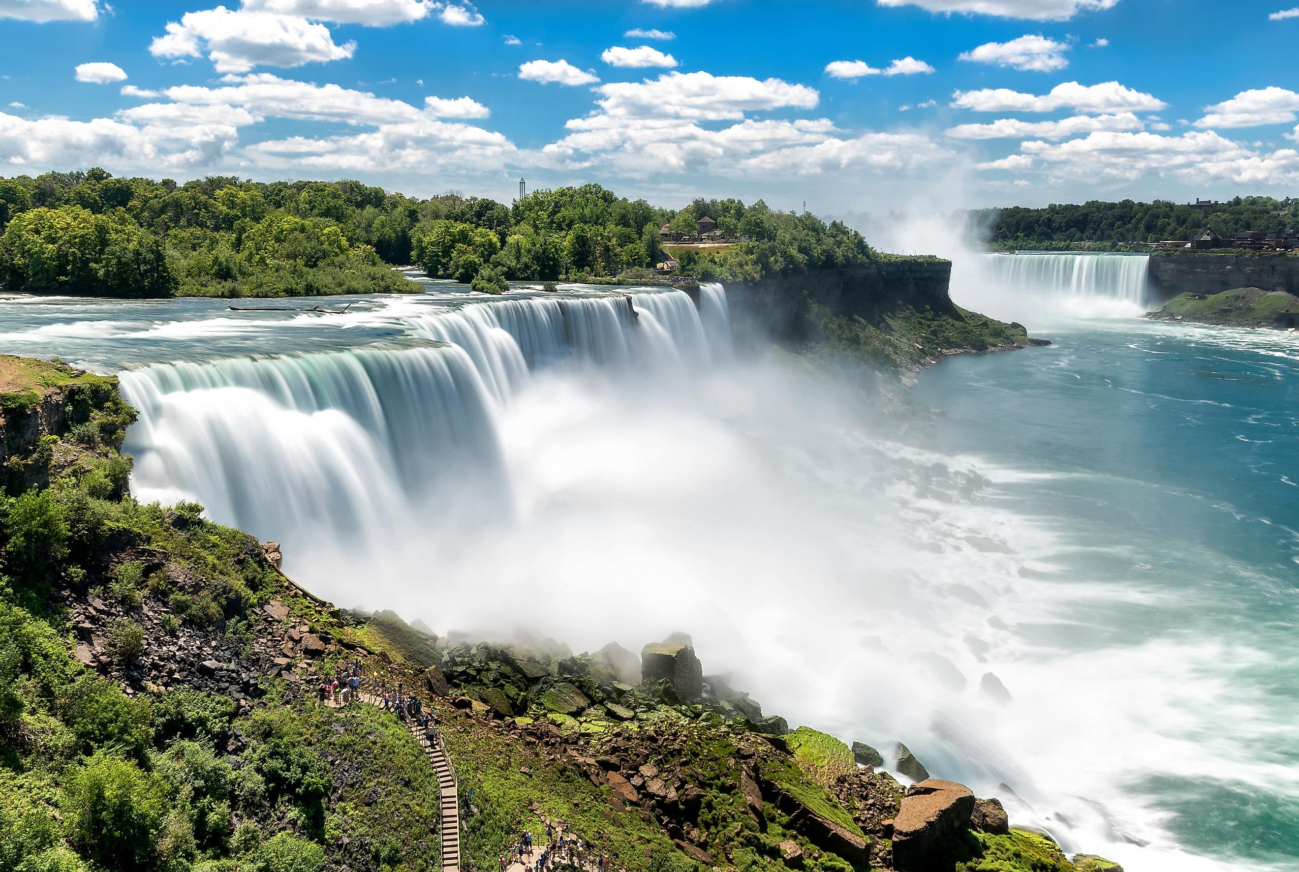
The Niagara Falls is a group of three waterfalls, namely the Horseshoe (Canadian) Falls, the Bridal Veil Falls, and the American Falls, that span the international boundary between the US State of New York and the Canadian Province of Ontario. Among the three waterfalls, the largest Horseshoe Falls is the only one situated on the Canada-US International border, whereas the other two falls are situated in the United States. The small Goat Island separates the Bridal Veil Falls from the Horseshoe Falls, while Luna Island separates the Bridal Veil Falls from the American Falls.
The Niagara Falls is positioned at the southern edge of the Niagara Gorge, about 121 km to the south-southeast of the Canadian city of Toronto and about 27 km to the north-northwest of the US City of Buffalo. Situated on the River Niagara, these combined falls have a vertical drop of at least 50 m and the highest flow rate among all the waterfalls in the North American Continent. It is estimated that more than 168,000 m3 of water passes over the crest line of the falls per minute during the daytime.
Geography

The Horseshoe (Canadian) Falls, which is considered the largest of the three waterfalls, has a width of about 790 m and an average drop of 57 m. Of the three falls, the Horseshoe (Canadian) Falls has the most powerful flow rate in North America. The American Falls is the second largest among the three waterfalls and drops between 21 to 34 m due to the presence of rock piles (talus) at its base. The American Falls has a width of about 260 m. The Bridal Veil Falls is the smallest among the three waterfalls and has a width of about 14 m and a total vertical drop of 36 m. During nighttime and in the winter season, the water flow of Niagara Falls is halved. Therefore, during this time, only 1,400 m3 of water passes over the crest line of the falls per second.

It is believed that Niagara Falls was formed approximately 10,000 years ago, as a result of the Wisconsin glaciation. The melting of the massive ice sheets left behind a chain of large depressions that were eventually filled with meltwater. This led to the formation of the Great Lakes of North America. As the ice thawed, the waters of the Upper Great Lakes drained into the Niagara River. The Niagara River then flowed through the newly formed terrain across the Niagara Escarpment. The yearly freezing and thawing of the Niagara River slowly wore the bedrocks. This wearing of the bedrocks along with periodic rockfalls resulted in shifting of the Niagara Falls further upstream. Geological studies have revealed that about 10,900 years ago, the Niagara Falls were situated between the US town of Lewiston and the Canadian Queenston, but the continued erosion of the crest has led to the retreat of the falls to about 10.9 km towards the south.
The waters of Niagara Falls serve as a major source of hydroelectric power. The efforts to harness the waters started in early 1750 when a small canal was built to power a sawmill. Currently, numerous hydropower plants have been built by both US and Canada along the Niagara River. Some of the major hydropower stations that are located along the Niagara River include The Robert Moses Niagara Hydroelectric Power Station and Sir Adam Beck Hydroelectric Generating Stations.
Brief History

Between 1300 and 1400 AD, human settlers from southwestern Ontario migrated to the Niagara Peninsula area. One of these early Indigenous tribes was known as Onguiaahra (Niagara). Another group of early settlers was an Iroquois group who were known as Atiquandaronk (Neutrals). According to the Iroquoian scholar Bruce Trigger, the name “Niagara” was derived from a confederation of Indigenous people who were known as Niagagarega. The first European to document Niagara Falls was Father Louis Hennepin, a Belgian missionary, in 1677. At the beginning of the 18th century, the Finnish-Swedish naturalist Pehr Kalm gave the first scientific description of Niagara Falls.
In 1679, the French built the first fort known as Fort Conti above Niagara Falls. This fort was eventually destroyed and the first permanent fort, Fort Niagara, was built in 1726. During the French and Indian War, the Niagara Fort was captured by the British. The Americans took control of the fort in 1796, but the fort was again captured back by the British in 1813. After the War of 1812, the Fort was handed over to the United States. The development of the New York Central Railroad in the 19th and 20th centuries opened Niagara Falls to tourism. In the early 1800s, the Falls also served as a popular honeymoon destination.