What and Where Is Devil's Garden?
The Devil’s Garden is located in Garfield County, Utah, USA, and is part of the Grand Staircase-Escalante National Monument (GSENM). The protected area has sandstone formations such as hoodoos and natural arches. On December 31, 1979, the United States Geological Survey (USGS) named the area the Devils Garden, which excluded the apostrophe. Within the National Landscape Conservation System, the natural monument goes by the name Devils Garden Outstanding Natural Area. The Devils Garden falls under the governance of the US Bureau of Land Management (BLM). Although often considered a Wilderness Study Area, Devils Garden it has not been officially designated as such by the BLM.
Geography and Features
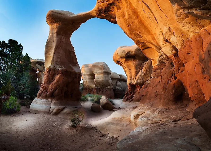
The Devils Garden has an area of about one square mile and the sits at an elevation of 5,243 feet. The nearest city is Escalante, Utah. Lake Powell and the Hole-in-the-Rock are located south of the Devils Garden, while Dixie National Forest is located to the north. The Escalante River is located to the east, whereas Straight Cliffs is located to the west. Features of the Devils Garden include the slender Metate Arch, which is near the center of the area, and the thicker Mano Arch. Other formations in the Devils Garden include many hoodoos that have different shapes and sizes, although only four prominent ones are popular among photographers.
Geology
The rock formations date back to the Middle epoch of the Jurassic period, about 166 million years ago, making it an area of interest for paleontologists. The GSENM has been the site of many dinosaur tracks and fossil discoveries. Natural forces such as erosion and weathering formed the natural arches in the Devils Garden. Some of rock is composed of hard caprock material, which is resistant to the effects of nature, and therefore they have been left relatively intact. The formation process includes thermal stress weathering caused by extreme temperature variations in the area. Other factors responsible for creating features in the Devils Garden are gravity and high-speed winds.
Visiting Devil’s Garden
The main access to the Devils Garden is the Hole-in-the-Rock Road, which begins about five miles east of the city of Escalante at the Scenic Byway 12 intersection. A sign marking "Devil's Garden" is located 12 miles along the unpaved road, and to the right is a dirt road leading to the Devils Garden. There are sandstone formations are near the parking lot, and the area has toilet facilities and picnic tables, but lacks water. Camping within the national monument requires a permit, but most visitors camp at the parking lot or along the Hole-in-the-Rock Road. Management prohibits the climbing of natural arches.
Grand Staircase-Escalante National Monument (GSENM)
initially encompassed an area of about 2,938 square miles until a December 2017 presidential proclamation reduced it to roughly 1,568 square miles. Apart from the Devils Garden, other features in the GSENM include the Willis Creek Canyon and Bull Valley Gorge Canyon in the western section of the monument, as well as the Paria River and the Paunsaugunt Plateau. The Kaiparowits Plateau is located at the center, while the Canyons of the Escalante are in the eastern part. Escalante, Kanab, Big Water, and Cannonville offer visitor centers.


