The Most Extreme Points Of Chile
The Republic of Chile is a South American nation that stretches along the western edge of the continent. The country borders the Andes to the east and the Pacific Ocean to the west with over 6,000 kilometers coastline on the Ocean. The total territory is about 291,930 square miles. Chile stretches over 2,670 miles from North to South but the width is barely 217 miles at the widest west-east stretch. The country has several dependency islands in the Pacific. Chile, therefore, is characterized by a wide variety of climates, landscapes, and other features. Santiago, the capital city, is located between the Andes and Coast Range mountains. This article highlights the extreme points of Chile, their location, history, and any interesting feature.
Northernmost Point in Chile
The Tripartite border in Parinacota province is the northernmost point in Chile. Lathough it is the country’s furthest north location, it has some settlement. The region is located at border with Peru and Bolivia at 17°29’54.0”S 69°28’6.5”W near Visviri and is helmet-shaped. The border town has a population of 265 according to 2002 census. To cross to Peru or Bolivia at Tripartite, one has to have his passport and other necessary document verified there. The larger Visviri region is the capital of General Lagos Commune and neighbors Charaña, a Bolivian settlement located to the east. At this point, trade has been known to take place for ages between Bolivia, Peru, and Chile.
Southernmost Point in Chile
There are two points that can be termed as the Southernmost in Chile. These locations are Aguila Islet of Diego Ramirez Islands and The South Pole in Magallanes. Both the two locations are in the Antartica Chilean region and their position will be validated if the Antarctic Chilean territory claims are considered. The Aguila Islet is located at coordinates 56°32’16”S68°43’10”W while South Pole is at 90°S0°W. The Southern region is characterized geographically by a long and narrow coastal cone on the western side of the Andes Mountain. Aguila is part of many islands known as the Diego Ramirez Islands located approximately 62 miles Southwest of Cape Horn along the Drake Passage. The Magallanes is a sparsely populated region though largely due to being either rugged or closed off for sheep rearing. It is the largest region in Chile, comprising of four administrative regions
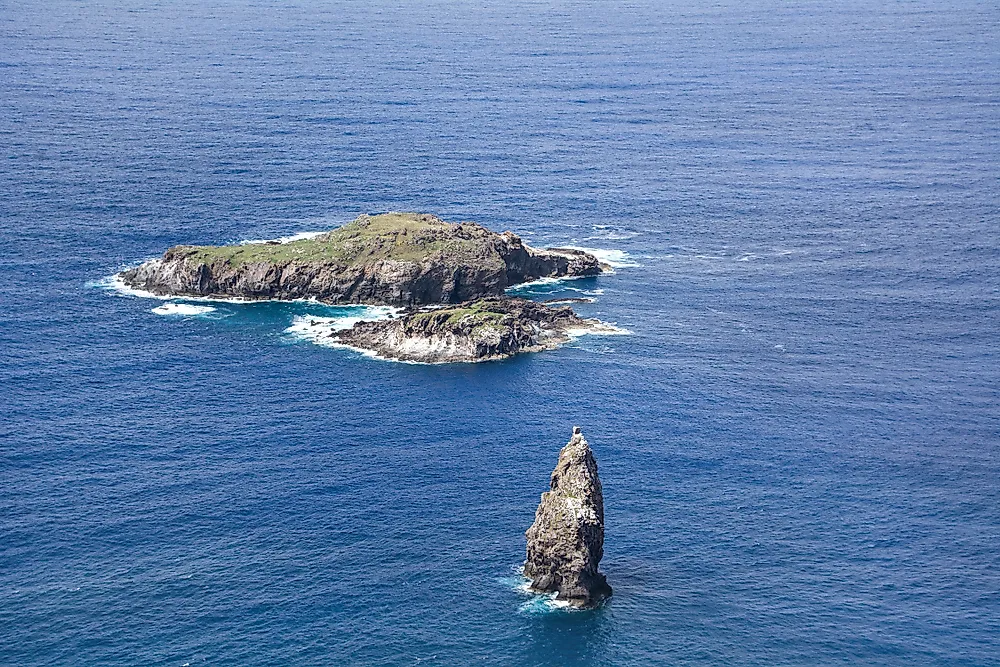
Westernmost Point in Chile
Motu Nui is the westernmost point in Chile and entire South America. Translated to mean largest island from the Rapa Nui language, the area has seabirds and is geographically characterized by large volcanic mountains with some over 2,000 meters above the sea level. The Island is one of the three islets situated south of Easter Island at 27°12’3.8”S 109°27”17.6” W. It was a famous place for the old “Bird Man” cult, a ritual held there which involved the collection of the first egg from Manutara. The only town in Motu Nui is Hanga Roa and the coastal line has been a major tourist attraction because of activities like scuba diving though sharks have always been a great threat. Seven varieties of seabirds including the sooty tern nest on the island. Tern’s eggs were used in the Bird Man game.
Easternmost Point in Chile
Chile has two location that can be categorized as being Eastern most. The first one is the Nueva Island in the Magallanes and Antartica Chilena. Nueva is one of the three islands on the Beagle Channel, a strait in the Tierra del Fuego archipelago and was a point of dispute with Argentina over ownership until an arbitration process gave Chile territorial ownership. Nueva Island is at 55°13’10.5”S 66°24’58.0”W and has mountainous peaks and glaciers. The second eastern point is the 53rd meridian west of Greenwich. The line of longitude defines Chile’s eastern point of territorial claim and extends from the North Pole to the South Pole across the Greenland, Atlantic Ocean, Southern Ocean, and South America. It forms a great circle with the 127th meridian east.
Highest Point in Chile
The highest point in Chile is the Ojos Del Salado located in the Atacama area. It is approximately 6,893 meters above the sea level and is the highest active volcano on the earth. The stratovolcano is located in the Andes on the border between Argentina and Chile. Ojos Del Salado is ranked as the second highest elevation in the Western Hemisphere as well as the Southern Hemisphere. The region is dry due to proximity to the Atacama Desert and a thin layer of snow can only be seen on the cap of the mountain during winter. However, despite being a very dry zone, the mountain hosts a permanent crater lake at 6,390 meters. The highest point of the Stratovolcanic Mountain was first summited by mountain climbers in 1937. The name Ojos Del Salado loosely translates to mean “Eyes of the Salty one” in Spanish in reference to the large salt deposits in the form of a lagoon or eye on its glacier.
Lowest Point in Chile
The lowest point in Chile is the Pacific Ocean which is on the sea level or zero meters above sea level. It is the largest and the deepest ocean on earth and extends from the Arctic Ocean to the Southern Sea. The extreme elevation is at the coastline in the west. The coastline which is approximately 3,999 miles marks the edge of Chile and is generally warm. The coastline is characterized by hot and dry summers while the winter weather is rainy and snow falls. The surface water temperatures vary from 29.5 °F at freezing point during winter to 86°F during summer near the equator. The lowest level at 0 meters has salinity that varies latitudinally along the Chilean coast since the country extends over a long distance.
Geographical Center of Chile
The country’s geographical center including the Easter Island is the South Pacific Ocean, approximately 687 kilometers west by south of Punta Arenas. This location is only considered when Antarctic territorial claim is included. However, when the territorial claim is excluded, Chile’s geographical center remains the South Pacific, approximately 737 southwest by west of Alejandro Selkirk Island. Considering only the mainland Chile, the center location is approximately 8 kilometers east of Colbun.


