Regions of Madagascar By Population
Madagascar is an island country found out the coast of East Africa in the Indian Ocean. It is approximately 250 miles off Mozambique's mainland. The country is made up of the main island of Madagascar and several other islands. Madagascar covers an area of 228,900 square miles, and it is the 47th largest country in the world and the world's 4th largest island.
Other neighboring island nations include the French territory of Reunion, the island of Mauritius, the island nation of Comoros, and the French territory of Mayotte. Madagascar has a population of 26,811,265 people as of 2019. The population density is approximately 120 people per square mile, and about 37.8% of the country's population lives in cities.
Regions Of Madagascar By Population
Administrative Divisions
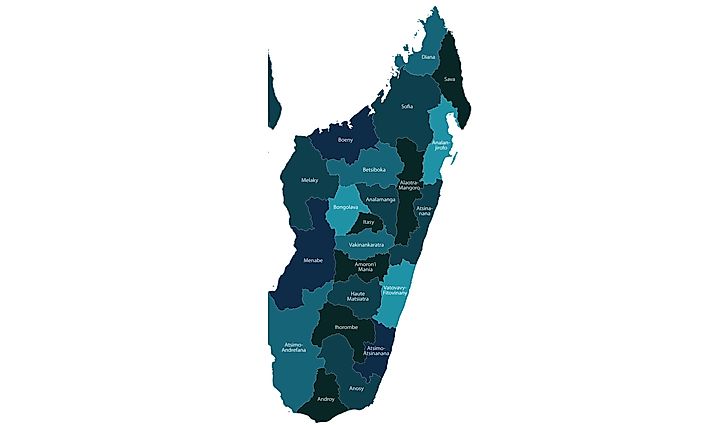
Madagascar has 22 regions which are also known as Faritra. They divide further into 119 districts. The districts then subdivide into 1579 communes and 17,485 Fokontany. Between 1975 and 1991 the period commonly known as the Second Republic, the country had five different levels, but today the country has only four levels which include faritany, mizakatena which is an independent province, Faritra region, Departemanta, and Koamina commune. The new constitution, enacted in 1992, states that the law will determine the numbers, names, and the limits of the territories in the country. The Parliament of Madagascar in 1994, created three different entities: the Region (Faritra), department (departemanta), and the commune (Kaominina).
Demographics
Estimates of Madagascar’s population as of 2016 was approximately 25 million people, and this was an increase from the 1900 population of 2.2 million people. The population growth rate in Madagascar was 2.9% in 2009. About 42.5% of the country's people are below 15 years of age, while 54.5% of the country's population is between 15 and 64 years. Those who are above 65 years account for 3% of the country's population.
Since the country gained its independence in 1960, it has carried out only two general censuses in the country, in 1975 and 1993. The region with the highest population in the country is the eastern highlands and the eastern coast while the Western Plains of the country is generally sparsely populated. There was an attempt carry out a population census in 2009, but as a result of the political instability it was not possible, and the population figures in the country are estimates, and more often there is a large margin of error depending on the sources of information on population demographics. According to estimates the country had a population of 24,894,551 in 2016, and in 2010 it was estimated that about 43.1% of the population were under the age of 15 while 53.8% were between the ages of 15 and 65 years while about 3.1% were above 65 years.
Ethnic Communities In Madagascar
The island nation of Madagascar’s largest ethnic community is the Malagasy ethnic group which is made up of approximately 18 sub-ethnic groups. Other communities found within the country include the Arabs and Indians who have lived on the island for a very long time and they have been assimilated into local communities to varying levels. Some have now identified themselves as Malagasy ethnic groups while others still maintain their identity and cultural separation.Other immigrants who settled in the country include the Chinese and the Europeans.
Regions of Madagascar By Population
| Rank | Region | Population |
|---|---|---|
| 1 | Analamanga | 3,348,794 |
| 2 | Vakinankaratra | 1,803,307 |
| 3 | Vatovavy-Fitovinany | 1,416,459 |
| 4 | Atsimo-Andrefana | 1,316,756 |
| 5 | Atsinanana | 1,270,680 |
| 6 | Sofia | 1,247,037 |
| 7 | Matsiatra Ambony | 1,199,183 |
| 8 | Analanjirofo | 1,035,132 |
| 9 | Alaotra-Mangoro | 1,027,110 |
| 10 | Sava | 980,807 |
| 11 | Atsimo-Atsinanana | 898,702 |
| 12 | Boeny | 799,675 |
| 13 | Androy | 733,933 |
| 14 | Itasy | 732,834 |
| 15 | Amoron'i Mania | 715,027 |
| 16 | Diana | 700,021 |
| 17 | Anosy | 671,805 |
| 18 | Menabe | 592,113 |
| 19 | Bongolava | 457,368 |
| 20 | Ihorombe | 312,307 |
| 21 | Betsiboka | 293,522 |
| 22 | Melaky | 289,594 |


