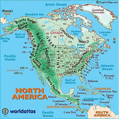
Landforms of North America - Mountain Ranges of North America, United States Landforms, Map of the Rocky Mountains - Worldatlas.com

Alaska Range
Mountains of south-central Alaska that extend from the Alaska Peninsula to the border of the Yukon Territory, Canada. The highest point in North America,
Mt. McKinley,
20,320 ft. (6,194 m) is located here.
Appalachian Mountains
The Appalachians, about 1,500 miles in length, extend from central Alabama in the U.S. up through the New England states and the Canadian provinces of New Brunswick, Newfoundland and Quebec.
Significant ranges include:
- The Cumberland Mts. in Tennessee
- The Blue Ridge Mts. in Virginia
- The Alleghenies in Pennsylvania
- The Catskills Mts. in New York
- The Green Mts. in Vermont
- The White Mts. of New Hampshire
The highest point is Mt. Mitchell in North Carolina at 6,684 ft (2,037 m)
Brooks Range
Mountains of northern Alaska. Highest point: Mt. Isto, 9,060 ft. (2,760 m)
Canadian Shield
This plateau region of eastern and northern Canada and the Great Lakes area of North America mainly includes rough and rocky surfaces, and large areas of coniferous (evergreen) forests. In addition, the northern regions along the Arctic Circle are comprised of rocky frozen tundra. The highest elevation is estimated at 1,640 ft (500 meters)
Cascades
A mountain range stretching from northeastern California across Oregon and Washington. Major peaks included Mt. Hood, Mt. Ranier and Mt. St. Helens.
Coast Range
Mountains running along the Pacific Ocean coastlines of California, Oregon, Washington. They also extend along the western border of British Columbia, Canada, and the southern edge of Alaska, all the way to Kenai Peninsula and Kodiak Island
Coastal Plain
This area of the southern and southeastern U.S extends to the continental shelf and is generally characterized by level (flat) land with assorted mixed forests. The coastal areas include bayous, deltas, marshes, mud flats and swamps.
Continental Divide
In North America the Western Continental Divide is an imaginary line that sits atop a continuous ridge of mountain summits that divide the continent into two main drainage areas. Details and map
Great Plains
The fertile Great Plains of North America slope east from the Rockies and extend to the edge of the Canadian Shield and the western edges of the Appalachians. The land is generally smooth with large treeless areas and sloping shallow river valleys. Minor hills and mountains are found in the Ozark Plateau of Missouri, and in the Boston Mountains and Ouachita Mountains of northwestern Arkansas and eastern Oklahoma. Sandhills and buttes cover parts of the north central U.S. in Nebraska.
Rocky Mountains
The Rocky Mountains, about 3,000 miles in length, extend from the U.S State of New Mexico up through the western United States and on into the northernmost reaches of Canada's British Columbia.
The Rockies include over one hundred individual mountain ranges.
Major ones include:
- Absaroka
- Bear River
- Beaverhead
- Big Belt
- Big Horn
- Bitterroots
- Canadian
- Clearwater
- Columbia
- Front
- Guadalupe
- Laramie
- Lemhi
- Lewis
- Lost River
- Medicine Bow
- Monashee
- Owyhee
- Purcell
- Sacramento
- Salmon River
- San Andres
- Sangre de Cristo
- Sawatch
- Shoshone
- Steens
- Stillwater
- Swan
- Tetons
- Unita
- Wallowa
- Wasatch
- Wind River
- Wyoming
- Zuni
The highest point in the Rockies is Mt. Elbert, located 10 miles southwest of Leadville, Colorado. It stands at 14,433 ft (4,399 meters).
Sierra Madres
Sierra Madres include two major ranges, and one smaller one.
The Sierra Madre Occidental runs parallel to Mexico's Pacific Ocean coastline, with several peaks exceeding 10,000 ft. (3,034 meters)
The Sierra Madre Oriental runs parallel to its Gulf of Mexico coastline, with a few mountains reaching 10,000 ft. (3,034 meters)
The Sierra Madre del Sur range is located in the southern Mexican states of Guerrero and Oaxaca.
Sierra Madres, and mountains of the Caribbean and Central America
The Sierra Madres also extend southeast into many of the Central America countries, with most being rainforest-covered volcanos.
Additional mountain ranges in Central America and the Caribbean include:
- Cordillera Central (Dominican Republic)
- Cordillera de Talamanca (Costa Rica)
- Cordillera Isabelia (Honduras/Nicaragua)
- Maya Mountains (Belize)
- Sierra de Bahoruco (Haiti)
- Serrania de Tabasara (Panama)
- Sierra Maestra (Cuba)
This mountain range of eastern California is about 400 miles in length. The highest point is
Mt. Whitneyat 14,494 ft. (4,418 meters).

- North America Capital Cities Map (53 countries)
- North America Continent Map
- North America Landforms Map
- North America Outline Map (black and white)
- North America Major Rivers Map
- North America Test Map (name the country)
- North America Time Zone Map
print this Landforms Map of North America
Show This map without country and state names