What Is The Biggest Time Difference Between Two Places In The US?
Here is an easy way to lose a bet. Ask someone how far apart two places in the United States can get on the clock. Most people picture a coast-to-coast phone call and guess three hours. They are off by roughly a full day. Stretch the question to include everywhere the American flag flies, and two US locations can sit a literal 24 hours apart: the same time on the clock, a different square on the calendar. So the real answer to "what is the biggest time difference between two places in the US?" depends entirely on where you draw the line.
First, Meet the Time Zones

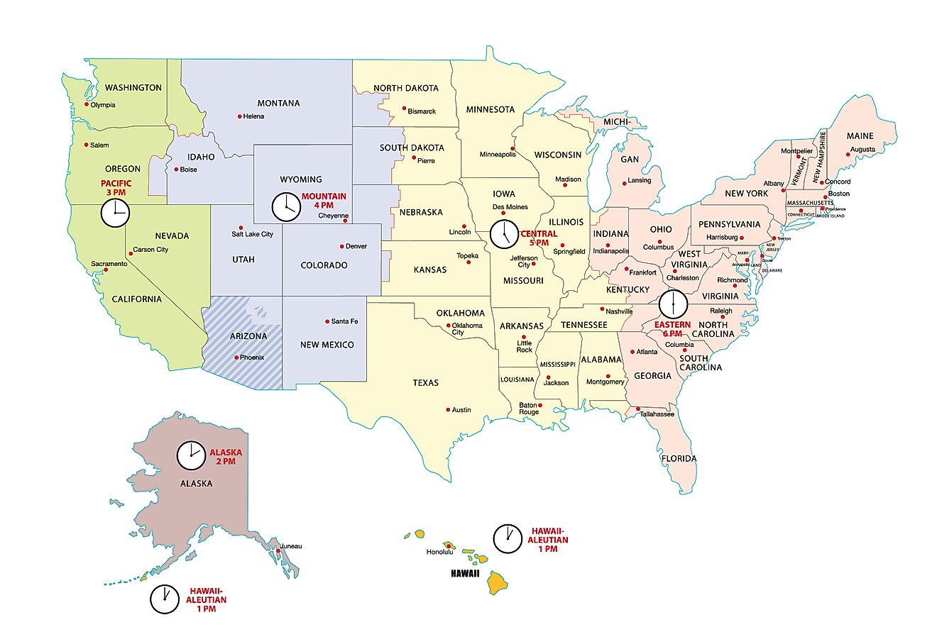
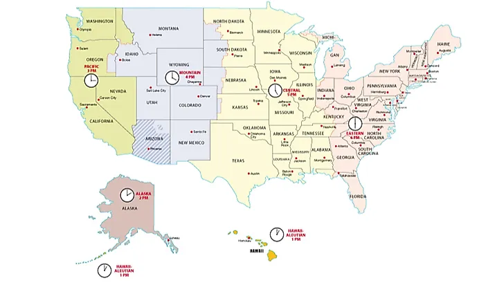
The 50 states spread across six time zones. Running east to west, they are Eastern (UTC-5), Central (UTC-6), Mountain (UTC-7), Pacific (UTC-8), Alaska (UTC-9), and Hawaii-Aleutian (UTC-10). The territories then add three more: Atlantic Time (UTC-4) in Puerto Rico and the US Virgin Islands, Samoa Time (UTC-11) in American Samoa, and Chamorro Time (UTC+10) in Guam and the Northern Mariana Islands. Count them all and the US works with nine official zones, more than almost any other country on the planet.

Pay attention to that last zone, Chamorro Time, because it is the troublemaker. Notice the plus sign: UTC+10. Guam and the Northern Mariana Islands sit on the far side of the International Date Line, which makes them the only piece of America that is ahead of Greenwich rather than behind it. Hold that thought.
One more wrinkle matters for the math: not everyone changes their clocks. Hawaii, most of Arizona, Puerto Rico, the US Virgin Islands, American Samoa, and the entire Chamorro zone skip daylight saving time and leave their clocks alone all year, while the rest of the country springs forward and falls back.
The 50-States Answer: About Six Hours

If you only count the states, the widest gap sits between Hawaii and the East Coast. Hawaii runs on UTC-10 and ignores daylight saving, so the distance to Eastern Time is six hours in summer and five in winter. When the clock reads noon in Honolulu, it is already six in the evening in New York during the summer. That is the tidy "six hours" answer you will often see quoted, and it is perfectly correct, right up until somebody mentions the territories. Somebody always mentions the territories.
The Territories Blow It Wide Open

This is where it gets entertaining. American Samoa, down in the South Pacific, keeps Samoa Time at UTC-11, the farthest-behind inhabited corner of the country. Guam and the Northern Mariana Islands keep Chamorro Time at UTC+10. Because Guam sits across the date line, it is not trailing the mainland at all; it is out ahead of everybody. The gap between American Samoa and Guam works out to 21 hours. To put it another way, when a shop is opening for Monday morning in American Samoa, a shop in Guam is nearly done with Tuesday. Same country, same currency, almost a full day between them.
And if you are willing to count the genuinely empty places, the gap stretches to a clean 24 hours. The uninhabited Baker and Howland Islands run on UTC-12, among the very last spots on Earth to begin any given date. Wake Island, also American and also nearly deserted, runs on UTC+12 on the opposite side of the date line. The difference between them is exactly one day: the two clocks read the same time, but the calendars never agree. That, technically, is the biggest time difference the United States can produce, and it happens entirely on American soil.
So What Is the Real Answer?
Pick your bracket. Among the 50 states, the biggest time difference is about six hours, between Hawaii and the East Coast. Among inhabited American soil, it leaps to 21 hours, between American Samoa and Guam. And once the empty outposts are allowed in, two US territories can be a full 24 hours apart. The country is so wide that it manages to lap itself on the calendar, which is a genuinely strange and rather wonderful thing to be able to say about a single nation.