Kaveri River
Also referred to as “Cauvery”, the Kaveri River is an 805km long river that flows through the Indian States of Tamil Nadu, Karnataka, Kerala, and the Union Territory of Puducherry. Rising in the Western Ghats’s Brahmagiri Mountain Range, the Kaveri River is Southern India’s 3rd largest river and the largest river in the Indian State of Tamil Nadu. Regarded as the “Ganges of South India” and worshipped as Goddess Kaveramma, the Kaveri River is revered as a “sacred river” by many pious Hindus and people of South India.

The name of the river has been derived from the Sankheti word ‘kaveri’ which means “one who brings abundance where she flows.” The Kaveri River and its tributaries serve as a vital source of water for irrigation and for the generation of hydroelectric power as well as for the sustenance of thousands of people who reside along its course.
Geography Of The Kaveri River

The Kaveri River originates at Talakaveri at an elevation of 1,341m, in the Western Ghats’s Brahmagiri Mountain Range that is situated in the Kodagu district in the southwestern part of the Indian State of Karnataka. The upper course of the Kaveri River is full of twists and turns and contains a rugged bed and elevated banks that are covered with rich vegetation. After flowing through a narrow gorge and falling about 18 to 24m in the rapids of Chunchankatte, the Kaveri River widens about 275 to 365m as it flows across the Karnataka Plateau. Throughout its course in the state of Karnataka, the flow of the Kaveri River is interrupted by 12 “anicuts” or dams that have been built for irrigation purposes. In Karnataka’s Mandya District, the Kaveri River joins with its two tributaries: Hemavati and Lakshmantirtha. Just below this confluence, a 39.8m high gravity dam has been constructed that has also led to the creation of the Krishna Raja Sagara reservoir.

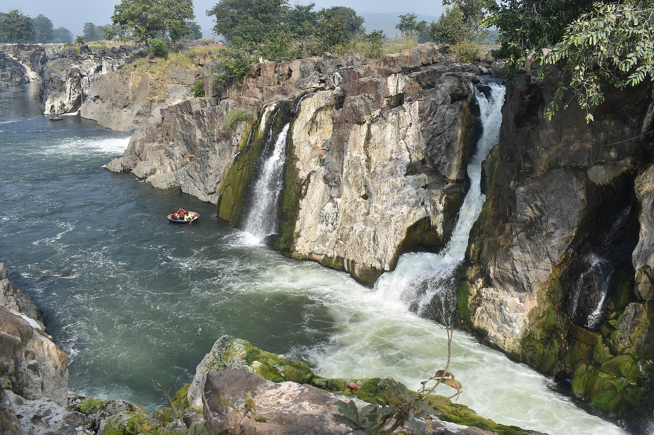
After the Kaveri River exits the hills of the Kodagu district, its flows onto the Deccan Plateau, where it forms the two sacred islands of Srirangapatna (Adi Ranga) and Shivanasamudra (Madhya Ranga) in the Mandya district of Karnataka that are situated about 80km apart from each other. At Shivanasamudra, the Kaveri River drops a total of 98m and forms the spectacular Shivanasamudra Falls that comprises two series of rapids: the Bharachukki and Gaganachukki. The Shivanasamudra Falls has an average width of 305m and an average volume of 934 cubic meters per second. The falls also served as the location of one of Asia’s first hydroelectric power stations that supply hydroelectric power to the Kolar Gold Fields and the cities of Mysuru and Bengaluru.

Through the Dharmapuri District, the Kaveri River then enters the State of Tamil Nadu and continues to flow through a series of gorges until it reaches the Hogenakkal Falls. Here, the river spreads out over an extensive area of sandy beaches and then flows in the southward direction to the 54m high Mettur Dam leading to the creation of the 160 sq. km Stanley Reservoir. The Kaveri River then flows through the districts of Erode, Namakkal, Karur and finally enters the Tiruchirappalli district. Here, the river splits into two branches: the Northern branch is called Kollidam, while the southern branch retains the name Kaveri and continues eastwards into the Thanjavur District. The ancient Grand Anicut dam was built by the Chola King Karikalan across the southern branch of the river. Both the branches of the river then join and form the Srirangam Island (Anthya Ranga). Before, draining into the Bay of Bengal, the Kaveri River breaks into many distributaries and forms a wide delta that is referred to as the “Garden of Southern India.” At the town of Poompuhar in Tamil Nadu’s Mayiladuthurai district, the Kaveri River finally drains into the Bay of Bengal. The river has an average discharge volume of 677 cubic meters per second.

Some of the principal tributaries of the Kaveri River include Amaravathi, Arkavathi, Bhavani, Hemavati, Harangi, Kabini, Lakshmana Tirtha, Noyyal, Shimsha, Suvarnavati, etc. The Kaveri River flows from the northwest to southeast direction and the catchment area of the Kaveri River basin drains an area of about 81,155 sq. km, which accounts for about 2.7% of the country’s total geographic area. The Kaveri River Basin extends over three states: Tamil Nadu (43,868 sq.km); Karnataka (34,273 sq.km); Kerala (2,866 sq.km) and one Union Territory of Puducherry (148 sq.km). The Kaveri Basin is surrounded by the Western Ghats in the west; the Eastern Ghats in the south and east and by the ridges that separate it from the Krishna and Pennar basins in the north. The Nilgiris extends eastwards to the Eastern Ghats and divides the river basin into two natural regions: the Karnataka Plateau in the North and the Tamil Nadu plateau in the south. The major types of soil that are found in the river basin include black soils, alluvial soils, red soils, forest soils, laterites, and mixed soils. A major part of the river basin is occupied by agricultural land which accounts for about 3% of the country’s total culturable area.
Significance Of The Kaveri River

For several years, the Kaveri River has served as a lifeline of the ancient kingdoms and many important cities of southern India. But in recent times, the waters of the river have led to serious disputes between the Indian States of Tamil Nadu and Karnataka over the sharing of the river water. As per an order by the Supreme Court of India in 2018, the state of Karnataka will receive 8.06 cubic kilometers of water, Tamil Nadu will receive 11.45 cubic kilometers of water, Kerala will receive 0.85 cubic kilometers of water and Puducherry will receive 0.2 cubic kilometers of water. In addition to this, about 0.28 cubic kilometers of water would be reserved for Environmental Protection and 0.11 cubic kilometers of water would be reserved for inevitable wastage into the sea.


