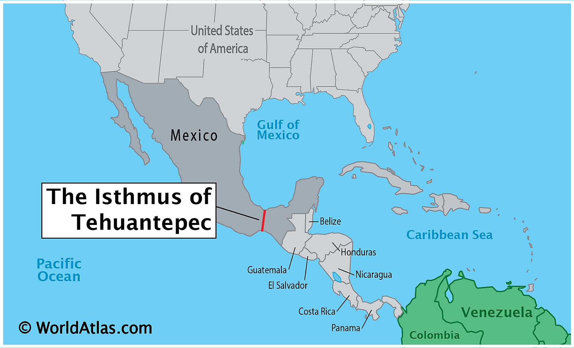
Isthmus of Tehuantepec
Isthmus of Tehuantepec is a narrow strip of land in southern Mexico located between the Gulf of Tehuantepec on the south and the Gulf of Campeche on the north. The two gulfs are connected by a 310-km-long railroad that runs from Salina Cruz to Coatzacoalcos. The Mexican isthmus is 200 kilometers wide at the narrowest point and provides the shortest distance between the Pacific Ocean and the Gulf of Mexico. Some sources consider the isthmus as the natural boundary between Central and North America. Isthmus of Tehuantepec is shared by the Mexican states of Veracruz and Oaxaca and separates the states of Chiapas, Yucatan, Tabasco, and Campeche from the rest of Mexico.
Geography Of The Isthmus of Tehuantepec
The Isthmus of Tehuantepec separates four southern Mexican states from the rest of the country and provides the shortest distance between the Pacific Ocean and the Gulf of Mexico. The isthmus is shared almost equally between the states of Veracruz and Oaxaca. The narrow strip, which runs through the southeastern parts of Oaxaca and Veracruz, also includes a small area of western Tabasco. The Isthmus of Tehuantepec is about 200 kilometers wide at the narrowest point across the Gulf of Tehuantepec and Gulf of Campeche and is 193 kilometers from the latter gulf to the Superior Lagoon on the Pacific coast.
The Isthmus of Tehuantepec has a highly diverse geography, ranging from tropical grasslands to extensive plains, isolated mountains, and arid lowlands. The 1,000-km Sierra Madre del Sur that begins in southern Michoacán terminates at the isthmus and transforms into a broad ridge, whose highest point is 224 meters above sea level. The isthmus’ highest elevation is at Chivela Pass that separates Sierra Madre de Oaxaca and the Sierra Madre de Chiapas and marks the boundary between North and Central America. Swamps and dense jungle dominate the isthmus’ northern side. The Selva Zoque, one of Mexico’s important ecological areas, covers the isthmus’ east-central region.
Climate
The northern part of the Isthmus of the Tehuantepec region is dominated by topical monsoon, while the southern area experiences a tropical savanna climate. Temperate climates dominate some small areas in the central region because of the high elevation. The Atlantic-facing northern slope receives the highest rainfall of about 3,960 millimeters annually. On the other hand, the Pacific-facing southern slope is much drier and receives little rainfall. The maximum temperature on the Atlantic slope is 35 degrees Celsius. The narrow Chivela Pass on the Sierra Madra Mountains allows the cooler, drier air to blow from North America to southern Mexico.
Population Of The Isthmus of Tehuantepec
The indigenous inhabitants of the Isthmus of Tehuantepec include Popolocas, Nahuas, Zoques, Mixes, Chontales, Huaves, and Zapotecs (mainly found on the isthmus’ Oaxaca half). These people groups are known for their diverse cultural heritage and linguistics despite their colonization and conquest. The region is known throughout Mexico for its unique and colorful costumes called “Tahuanas” and worn by women. The isthmus communities are characterized as matriarchal societies because they practice gender equality, with the women having strong personalities. The region’s cuisine is mainly traditional foods, with popular dishes including tamales, Garnachas, and guetabingui.
Intraoceanic Routes
The isthmus’ strategic location and geography make it a favorable site for the construction of interoceanic routes and canals between the Pacific Ocean and the Gulf of Mexico. In the 18th century, Hernan Cortes proposed the construction of a canal on the isthmus in one of his letters to King Charles V. The region was first surveyed in detail in 1771. In the 19th century, the Mexican government granted several concessions to foreign promoters to explore and construct a route or canal across the isthmus. However, no route or canal had been completed by the end of the 19th century. The 308-km Tehuantepec Railroad, inaugurated in 1907, links Coatzacoalcos to Salina Cruz.