11 Most Scenic Road Trips to Take in New Jersey
You may think of the Jersey Shore TV show and the adjacent New York City when hearing the name "New Jersey." However, New Jersey is so much more than the little sibling of the Big Apple. New Jersey offers some of the most diverse landscapes, including Jenny Jump Mountain to the north and the Atlantic City coastline to the south.
Road trips in the US are a popular pastime for Americans, but most people think of the Midwest and West Coast for these types of adventures. But the East Coast also has a ton to offer, with New Jersey being one of the most exciting locations. Check out Jenny Jump State Park and the vast Pine Barrens, among others, for the most scenic road trips in the state, all from the comfort of your vehicle.
The Pine Barrens

The New Jersey Pine Barrens, also known as the “Pine Barrens” or “the Pines,” is one of the most stunning locations in Jersey. It covers 1.1 million acres and stretches between 5 counties and 16 municipalities. Three routes allow travelers to experience the entire region, including the south, central, and northern paths. However, you’ll have to take all three if you want to see the whole Pine Barrens that run up New Jersey's coast.
Combined, these routes average about 130 miles and can take more than a day to complete. There’s no need to rush since the Pine Barrens offer some of the most spectacular nature views in the whole state, especially in the Spring or Fall.
Palisades Scenic Byway

Palisades Scenic Byway is not the longest road trip in New Jersey, but it is one of the most stunning. This scenic road system takes travelers along the Hudson River for much of the way and provides an awesome view of New York City. Despite its proximity to the city, most of the parkway is along naturally preserved forests and cliff faces.
The road only stretches for approximately 20 miles in New Jersey (42 if you follow it into New York). However, it's the perfect place to spend the afternoon with many hiking trails and historic sites commemorating the importance of the Palisades' during the American Revolution.
Batsto Wilderness Route

Batsto Wilderness Route is also known as Route 542 since it runs primarily along this roadway. It begins in the small town of New Gretna and ends in Hammonton, with a lot to see in between. It's mostly a wooded region since it is part of the Pine Barrens, although much shorter than the full Pine Barrens path. It's a great place to visit when the foliage changes in the fall, but it’s also a favorite summer getaway to avoid crowds at the shore.
While traveling this road, the Batsto State Park and historical village are must-see locations. If you enjoy learning about local history, hearing legends, and exploring the forest, then it’s a good idea to take some time to get out of your vehicle and explore the area.
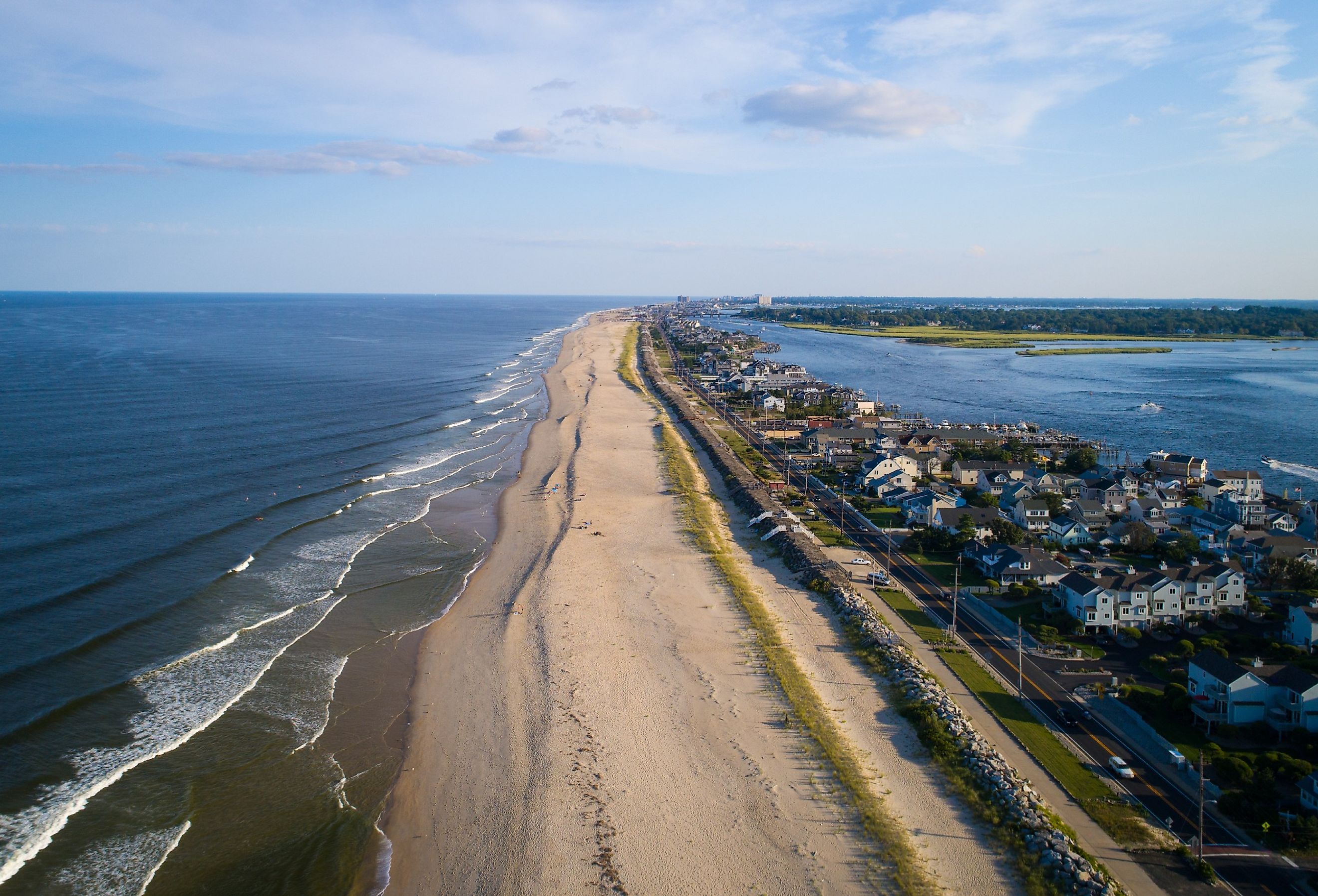
Jersey Shore

New Jersey is a coastal state, meaning the entire western border touches the Atlantic Ocean. Travelers can choose to drive the whole duration of the shoreline, which stretches for about 166 miles; however, the exact distance depends on which path you decide to follow.
The Garden State Parkway and parts of Route 18 South are ideal ways to travel from the south to the northern points. Traveling between Cape May in the south to Montclair in the north is perfect and stretches for approximately 157 miles. It takes drives past several wildlife sanctuaries and prominent shore towns.
Kittatinny Ridge Loop

The Kittatinny Ridge Loop rests just a few miles from the New Jersey-Pennsylania border. This path starts near the Delaware Water Gap and takes travelers clockwise until it ends near Hampton Township. Most of the journey takes you through Worthington State Forest, which offers spectacular woodland and waterway views.
Many out-of-state residents don’t expect to see this fantastic wilderness in the north of Jersey. It's near Jenny Jump State Forest and the Land of Make Believe, making it the ideal summer trip for the whole family.
Route 15

Route 15 takes travelers between Augusta in Frankford and Dover in Morris County. While the ride is only about 30 minutes long, it takes travelers past stunning views of lakes, rivers, and mountainsides. Thanks to the area's many charming lakes, like Lake Mowhawk, and local parks, it's easy to turn this journey into a day trip.
Adventurous explorers can continue traveling north from Augusta to High Point State Park to check out the Appalachian Trail. Or, head south to stay at Mahlon Dickerson Campground to explore the wilderness.
Delaware River Scenic Byway

The Delaware River Scenic Byway offers some of the most amazing views of the Delaware River along the Pennsylvania and New Jersey border. One of the unique features of this pathway is how it takes travelers through scenic views of nature and lovely small towns with distinctive charms.
Stockton in Hunterdon County is one of the loveliest townships this roadway will take you through. This college town is a great place to get a bite to eat and walk around for a few hours. Tourists should also stop by John A. Roebling Memorial Park in Mercer County, another excellent spot to check out along the road trip.
Route 519 (Land of Make Believe Highway)

Route 519 is also known as the Land of Make Believe Highway and Bridgeville Road. It's predominantly located in northern Jersey and takes travelers through some of the most gorgeous wildernesses of the state. There are many possible starting points, but beginning in Harmony Township is an excellent choice.
This path will take adventures past the Pequest River and mountain ranges to the north. You can also end the trip at the Land of Make Believe, one of the most fun and entertaining parks in New Jersey.
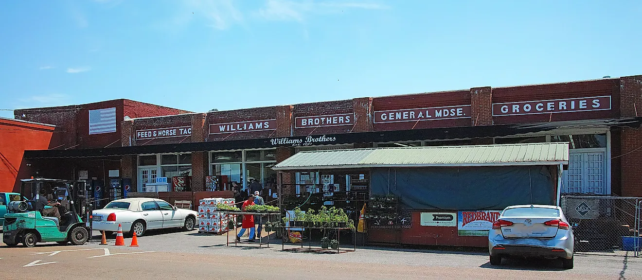
Route 521

Route 521 takes travelers through a more than 43-mile tour of New Jersey. This route ends in the south at route 519 and ends in the north by Maple Avenue near the border of New York. This route takes drivers on a north-south route through several townships and past many parks and streams.
Most of the roadway is a two-lane road that takes you through the northwestern parts of the state. One must-see location is the Middleville General Store, the oldest general store in the state, dating back to 1876.
Route 29 (Washington Crossing)

Route 29 is just shy of 35 miles and takes travelers through the southern part of New Jersey. Sections of the roadway will bring you through Trenton, the state's capital, with some beautiful sites to see. However, Washington Crossing State Park is certainly the highlight of this trip.
Washington Crossing State Park is the site where George Washington and the Continental Army crossed the Delaware River on Christmas night during the Revolutionary War. It is a richly historic place with lovely trails and wildlife to explore while visiting.
Pulaski Skyway (Route 1/9)

Route 1/9 is one of the major highways of New Jersey, connecting several small towns together and improving travel throughout the state. The trip's highlight is the Pulaski Skyway, a three-and-a-half-mile bridge stretching over the Hackensack and Passaic Rivers. It gets its name from General Casimir Pulaski, a Revolutionary War hero who, legend has it, saved George Washington once.
The bridge is an essential connection point for routes 1 and 9. You can choose whichever route you prefer as your starting point, but taking the route between Jersey City and Newark is the best choice.
You may worry that traveling through New Jersey is slow and tiresome because it is the most densely populated state in the US. However, many county routes in New Jersey aren't heavily trafficked and are wide enough to accommodate many vehicles without the need to tailgate. New Jersey is abundant in vegetation, with over 2 million acres open and protected from development, perfect for scenic road trips. New Jersey is full of regions with few inhabitants and extensive tracts of wilderness, including the Wharton State Forest, the state's largest State Park, that are waiting for visitors to explore.
_at_U.S._Route_9_(New_York_Road)_in_Bass_River_Township,_Burlington_County,_New_Jersey.jpg)
_just_south_of_New_Jersey_State_Route_94_in_Blairstown_Township,_Warren_County,_New_Jersey.jpg)