Where is Orange County, California?
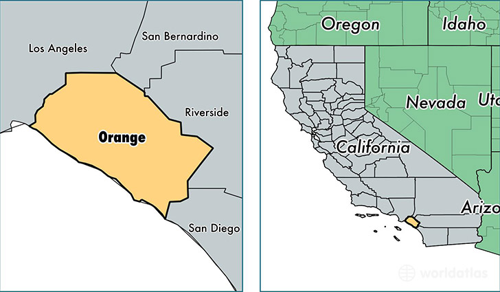
Orange County is a county equivalent area found in California, USA. The county government of Orange is found in the county seat of Santa Ana.
With a total 2,455.51 sq. km of land and water area, Orange County, California is the 842nd largest county equivalent area in the United States. Home to 3,145,515 people, Orange County has a total 1059986 households earning 75422 on average per year.
Orange County, California offers the following attractions to visitors: Richard Nixon Library, Disney California Adventure Park, Disneyland Resort, Knott's Berry Farm
Orange is the home to these professional sports teams: Angels (MLB), Anaheim Ducks (NHL)
Orange County, California - Quick Facts
| FIPS Code | 6059 |
| Area Codes | 714,562,949 |
| Time Zone | PST |
| Major Cities | Anaheim (population: 363,880), Santa Ana (population: 357,369), Irvine (population: 218,206), Huntington Beach (population: 195,296), Garden Grove (population: 177,366), Orange (population: 145,450), Fullerton (population: 138,307), Costa Mesa (population: 113,792), Mission Viejo (population: 97,319), Westminster (population: 92,129) |
| Land Area | 1,214,490 sq miles |
| Water Area | 791 sq miles |
| Household Income | $75,422 |
| Housing Units | 1,059,986 |
| Median Home Value | $519,600 |
| High School Grads | 84% of population |
| Holders of Bachelors Degrees | 37% of population |
| Retail Spending | $15,221 per capita |
| Food & Accomodation Sales | $8,247,828 per capita |
| Universities and Colleges | Thanh Le College School of Cosmetology, Asian American International Beauty College, Career Academy of Beauty, Southern California Institute of Technology, Argosy University-Orange County, Alliant International University-System Office, University of California-Irvine, Coastline Community College |