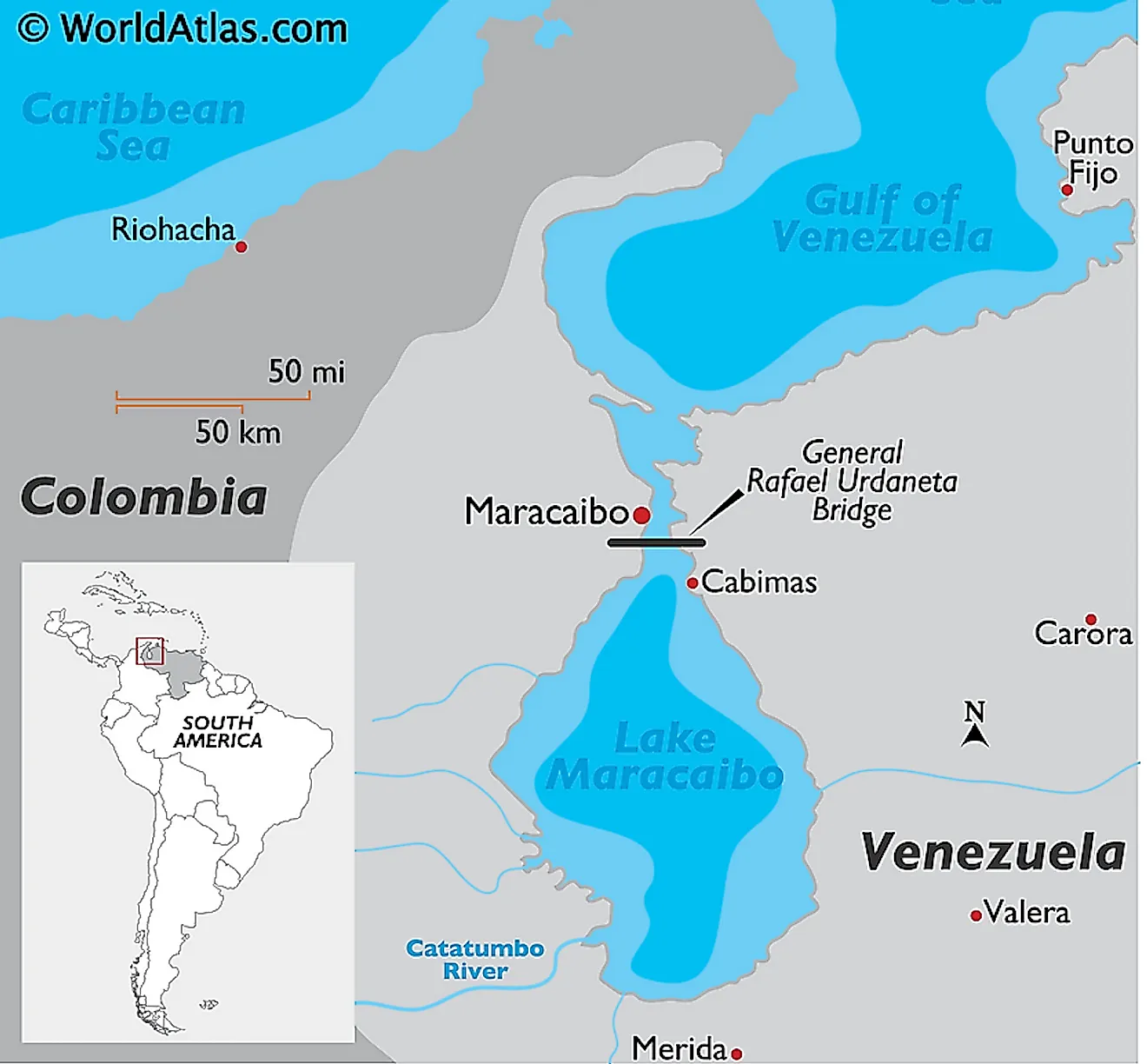
Gulf Of Venezuela
The Gulf of Venezuela, also known as Golfo De Venezuela, is an inland sea located between Venezuela on the east, south, and west, and Colombia on the northwest. The gulf opens into the Caribbean Sea on the north and exchanges water with a tidal bay on the south known as Lake Maracaibo. Some segments of the gulf are the subject of a longstanding dispute between Venezuela and Colombia. Although the contested areas are relatively small, the possible presence of petroleum deposits has made it difficult to resolve the dispute, despite the involvement of a bilateral commission. The Gulf of Venezuela is an important shipping route for vessels transporting petroleum from the Lake Maracaibo region.

Geography
The Gulf of Venezuela is one of the inlets of the Caribbean Sea located on the northernmost boundary between Venezuela and Colombia. The gulf separates the Paraguana Peninsula on the east and Guajira Peninsula on the west. The Paraguana Peninsula is wholly under Venezuela’s jurisdiction and contained within the Falcon State. The Guajira Peninsula (known as La Goajira Peninsula in Colombia) is shared by Guajira Department (Colombia) and Zulia State (Venezuela) countries. Much of the gulf’s coastline is within Venezuela’s sovereignty, while Colombia has a short coastline on the northeastern tip of the Guajira Peninsula.

The Gulf of Venezuela extends about 120 kilometers long from north to south and 240 kilometers wide. It spills into Lake Maracaibo through the 5.5 kilometers wide Tablazo Bay and an 11-meter deep channel near Maracaibo City. The gulf receives saline water from the Caribbean Sea on the north, then spills into the lake, making the lake’s water brackish. Several rivers drain into the Gulf of Venezuela mainly through Lake Maracaibo. These rivers include Motatan, Escalante, Chama, and Gatatumbo. Maracaibo’s water flowing into the gulf contains loads of sediments deposited into the lake by numerous rivers. Lowlands surround the gulf, with little or no cultivation taking place on its coast.
Border Dispute
Colombia and Venezuela were both led to independence by Simon Bolivar. After independence, the two countries joined with Panama and Ecuador to form one nation known as Gran Colombia, which disintegrated in 1831. After the disintegration, Venezuela and Colombia have gone through periods of bilateral struggles, with some conflicts resulting from border disputes. The delimitation of the water boundary in the Gulf of Venezuela has been a subject of a longstanding dispute between the two countries.
Venezuela and Colombia dispute the existing water boundary between them, with no country recognizing the borderline established by the other. In 1939, Venezuela allocated itself most of the gulf by delineating a borderline from Castilletes Village on the Guajira Peninsula to Paraguana Peninsula. The move by the Venezuelan government angered the Colombian government, who reacted in the late 1940s by asking Venezuela to follow the UN Convention on Law of the Sea in drawing the borderline. In 1941, the two countries signed the Venezuela-Colombia Boundary Treaty, calming the tension between them. Tension escalated again in 1987 when the Colombian military refused to leave the disputed water, forcing Venezuela to send fighter jets. The dispute resurfaced under Nicolas Maduro’s Presidency.