12 Most Peaceful Small Towns In Pennsylvania
If you map Pennsylvania by sound, a second state appears between the interstates: a lattice of porch creaks, towpath bikes, mill wheels, and river eddies. That’s the Pennsylvania this list is about. We looked for towns where calm isn’t a mood but an infrastructure choice, places buffered by state forests and water, stitched with footpaths, and small enough that a bell tower still keeps time.
This isn’t a nostalgia tour or a spa roundup. It’s a field guide to durable quiet: gas-lit blocks that haven’t switched to LEDs, canal towns that still carry water instead of traffic, rail beds reborn as green corridors, lakes with no roar of engines after dusk. The dozen that follow show how peace survives when it’s built into the bones, town by town, creek by creek, across the Keystone State.
Bedford

Bedford is known for its 19th-century mineral springs resort, which once attracted U.S. presidents and European aristocrats. The Omni Bedford Springs Resort still stands as a restored National Historic Landmark, one of the few places in the country where the original spa waters still flow. Surrounding the town are forested ridges and wide valley farmland that give Bedford a sense of deep-set calm, anchored by the Alleghenies just beyond view. Despite its historical weight, the town remains understated and uncrowded, with a center defined by preserved architecture and a rhythm that hasn’t changed in decades.

The town’s covered bridges offer a niche driving loop that feels untouched by time, including the photogenic Claycomb Bridge next to Old Bedford Village, a living history site with over 30 relocated buildings. Shawnee State Park, 10 miles west, has a quiet lake loop and boat rentals, with dense forests that stay cool in summer. The National Museum of the American Coverlet, located in a former schoolhouse, is an unusual stop, its textile displays highlight regional craftsmanship with real aesthetic impact.
Ridgway

Ridgway’s claim to quiet isn’t just geography, it’s cultural. Known as the “Lily of the Valley,” the town sits in the heart of the Pennsylvania Wilds and was once the hardwood capital of the world. Its legacy lives on in the annual Chainsaw Carvers Rendezvous, a week-long international event that leaves intricate wood sculptures scattered throughout town year-round. Ridgway is also the gateway to the Clarion-Little Toby Rail Trail, a 19-mile path used more by locals than tourists, with stretches along moss-covered riverbanks and shaded forests that don’t see car traffic or noise.

Downtown, the Ridgway Historic District offers a grid of late 1800s homes and civic buildings, many designed by local architect J.P. Bailey, that remain in near-original condition. Coffee at The Creative Cup comes with delicious brews, while lunch at Joey’s Bakery includes homemade soup and house-baked bread in a no-frills setting. South of town, the Twin Lakes Recreation Area offers non-motorized canoeing and pine-shaded picnic grounds, all tucked in the Allegheny National Forest.
Clarion

Clarion is defined by its position above a deep, forested valley where the Clarion River bends quietly through northwest Pennsylvania. Though best known today as a university town, Clarion’s roots are industrial, its economy once tied to glassmaking and oil. It now moves at a slower pace, shaped more by the surrounding state parks and the seasonal rhythms of a college calendar than any commercial industry. Every autumn, the town hosts the long-running Autumn Leaf Festival, but outside that brief surge, Clarion remains subdued, its streets calm even during the academic year.

Main Street has several functional anchors, including Michelle’s Café, where locals gather for espresso and quiet conversation under rotating art exhibits. For trails and uninterrupted quiet, the Clarion Loop of the North Country Trail skirts town and connects with winding access points into Cook Forest State Park, known for its preserved old-growth hemlocks. Clarion River Brewing Company offers house-made beers and straightforward pub food in a restored downtown building. South of town, the Clarion Borough Boat Launch allows for quiet canoe launches and shaded walks without the crowds found farther east.
Honesdale

Honesdale’s identity is tied to movement, railroads, rivers, early American industry, but its pace now is still. It was the site of the first commercial steam locomotive run in the U.S., a 19th-century event that feels distant in a town where time doesn’t press. Set at the meeting of the Lackawaxen and Dyberry creeks, Honesdale is ringed by forested hills and layered with old brick buildings that haven’t changed purpose in decades. The former train station now houses the Wayne County Historical Society, which preserves the original Stourbridge Lion replica in a space that’s usually empty enough to hear your footsteps.

On Church Street, Native Food & Drink serves seasonal plates from a tightly edited menu, often sourced from nearby farms. It faces Gravity Alley, one of the town’s best seasonal ice-cream stand sites and a former bowling alley. Just outside the center, Prompton State Park offers uncrowded hiking loops and shoreline access to Prompton Lake, where non-motorized boats drift into coves under pine. On weekends, Black & Brass Coffee Roasting Co. becomes a steady pulse, with large windows facing the Dyberry and a soundtrack set low.
New Hope

New Hope’s calm is structured by contrast. Set on the banks of the Delaware River, it sits across from New Jersey’s Lambertville, connected by a short walkable bridge that once carried streetcars. While its name reflects optimism, the town’s historic spine is industrial: a canal lock village built around the Delaware Canal, where mules once towed cargo barges past limestone towpaths. That canal still flows, now flanked by the Delaware Canal Towpath trail, which runs parallel to quiet stretches of the river for dozens of uninterrupted miles.

The town’s most still corners are just off the main commercial strip. At Bowman’s Hill Wildflower Preserve, over 700 native plant species grow under forest canopy, crisscrossed by wooden footbridges and gravel trails. Farther inland, the Bucks County Playhouse sits in a converted mill overlooking the water; performances break up the quiet but leave the riverside unchanged. Mornings are slowest at Nektar, where charcuterie and wine are paired with outdoor tables just above the canal.
Ligonier

Ligonier centers itself around a traffic circle. Locals call it “The Diamond,” and it functions more as a gathering lawn than a road feature, lined with independent shops, iron benches, and a restored bandstand. The town began as a military fort during the French and Indian War, and Fort Ligonier still stands, fully reconstructed and open to the public. The fort’s museum includes 18th-century British weaponry and personal items from General John Forbes, all displayed with minimal noise or crowd. Unlike many towns with colonial heritage, Ligonier has kept its history visible but quiet.

West of the Diamond, Abigail’s Coffeehouse fills early but clears by midmorning, and the back window offers a view of rolling rooftops and trees that lead into the Laurel Highlands. Just beyond town, Linn Run State Park offers waterfalls and fire roads with minimal foot traffic, especially along the Grove Run Trail. The Ligonier Valley Rail Trail traces the edge of Loyalhanna Creek, with sections passing through farmland and shaded forest. For lunch, Eastwood Inn serves trout, pasta, and potatoes with no background music and no pretense.
Ohiopyle

Ohiopyle exists for the river, but it doesn’t depend on it. The Youghiogheny curves hard through town, narrowing into rapids that define the geography and the pace. Whitewater draws day visitors, but Ohiopyle itself is small, fewer than 100 residents, and sits almost entirely inside the boundaries of Ohiopyle State Park. There are no traffic lights. The Great Allegheny Passage rail trail runs directly through town, following the old Western Maryland Railway line, bordered on one side by forest and on the other by quiet brick buildings repurposed into cafes and outfitters.

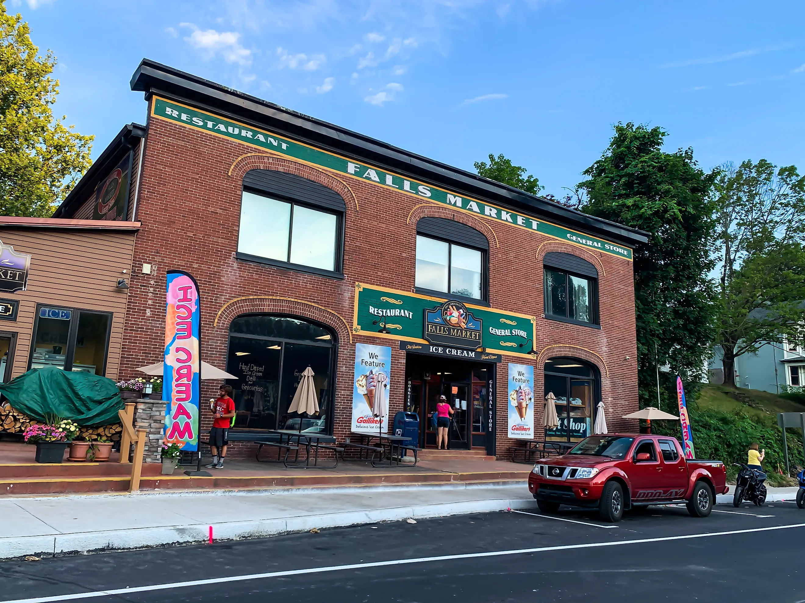
Falls Market occupies a corner building that once served as the town general store, now a diner and small grocery with creaky floors and a front porch facing the Yough. Up the hill, Laurel Highlands Falls Area Visitor Center looks directly over the main falls, with a deck built for silence rather than spectacle. Baughman Rock Overlook, accessible by car or foot, offers one of the widest elevated views in western Pennsylvania with no sound but wind. Across the river, Meadow Run’s natural waterslides and rock formations remain accessible yet rarely crowded outside peak weekends.
Eagles Mere

Eagles Mere was built to be quiet. Established as a resort town in the late 19th century, it developed without rail access to keep industrial noise out. That isolation shaped its identity. The town surrounds a spring-fed lake, Eagles Mere Lake, that remains private, protected by a local association and circled by the Laurel Path, a narrow walking trail shaded by pine and hemlock. The village never grew past a few hundred residents, and its layout hasn’t changed. Most of the buildings date to the early 1900s, built for summer families and kept intact through seasonal use.

The Eagles Mere Bookstore, inside a converted carriage house, operates in silence except for the sound of a ceiling fan and creaking floorboards. Across the street, the Eagles Mere Museum displays maps, ledgers, and photographs from a time when steamboats crossed the lake and automobiles were discouraged. For a clear view of Loyalsock Creek and uninterrupted hiking, the Loyalsock Trail crosses Rock Run, about fifteen minutes by car. The Sweet Shop, a combination café and ice cream counter, closes early and serves mostly return visitors.
Hawley

Hawley was shaped by water and electricity. It supplied ice to New York City in the 19th century and later became the founding site of the Pennsylvania Power & Light Company. The town still centers around hydroelectric remnants, the old Silk Mill, now repurposed as a marketplace and lodging, overlooks the Lackawaxen River and remains powered in part by the current. Hawley’s streets are narrow and quiet, with stone walls and cast-iron bridges framing each entry to town. Lake Wallenpaupack, just south, controls the seasons, boating in summer, fog in fall, stillness in winter.

Inside the Hawley Silk Mill, Cocoon Coffeehouse & Bakery serves small-batch pastries and roasts, with seating angled toward the forested riverbank. A mile down Route 6, the Dorflinger-Suydam Wildlife Sanctuary maintains over 500 acres of trails and meadows, along with a glass museum that catalogs the region’s cut-crystal legacy. On the far edge of town, the Hawley Rail Trail crosses small creeks and former trolley lines with minimal foot traffic. For dinner, The Settlers Inn offers fixed menus in a Craftsman-style lodge overlooking the Lackawaxen.
Milford

Milford was founded by a mapmaker. John Biddis, one of America’s early surveyors, laid out the town in 1796 based on Philadelphia’s grid, but compressed into a few walkable blocks. The streets are named for his children, Ann, Catharine, Elizabeth, and still follow the original plat. What sets Milford apart is its alignment with both nature and federal architecture: stone sidewalks, symmetrical facades, and forested ridges that push in close to the edge of town. The entire borough is a National Historic District, bordered by the Delaware Water Gap National Recreation Area, which keeps expansion in check.

Grey Towers National Historic Site sits just above the village and anchors the region’s conservation history. Once the home of Gifford Pinchot, the first chief of the U.S. Forest Service, the estate includes formal gardens and a stone “finger bowl” dining table used for outdoor meetings. A short drive south, Raymondskill Falls drops in three tiers, the tallest waterfall in Pennsylvania—with a trail loop that remains quiet midweek. Back in town, Bar Louis inside the Hotel Fauchère offers late lunch under pressed tin ceilings with no background soundtrack.
Wellsboro

Wellsboro is lit by gas lamps. Installed in the early 20th century and still functional, they line Main Street in a straight row beneath large elms, giving the town a fixed, timeless appearance even as seasons shift. It was built as a courthouse town, anchored by the Tioga County Courthouse and a central green shaped like a compass. But Wellsboro’s identity hinges on its proximity to Pine Creek Gorge, known locally as the Pennsylvania Grand Canyon, which begins just west of downtown. The gorge runs nearly 50 miles and stays quiet even in high season, with foot traffic absorbed by layered overlooks and long trails.

Leonard Harrison State Park provides a clear entry point to the canyon’s edge, with access to the Turkey Path Trail, which descends by waterfalls to the creek bed. Inside town, Café 1905 on Main Street operates inside Dunham’s Department Store and serves coffee with views of the park circle. Across the street, the Arcadia Theatre still runs single-screen films under its original marquee. The Pine Creek Rail Trail, accessible north of town, allows for uninterrupted biking or walking for hours without noise.
Jim Thorpe

Jim Thorpe is built into a gorge. The town’s original name, Mauch Chunk, means “Bear Mountain” in Lenape, and it wraps tightly around the Lehigh River as if tucked into the Appalachian fold. When it was renamed in 1954 to honor the Olympic athlete buried there, the surrounding landscape didn’t change, steep slopes, switchback rail lines, and narrow Victorian streets still define its shape. The town rises in layers, with homes and staircases climbing the mountainside, and sound dissolving into elevation. Unlike typical grid towns, Jim Thorpe’s topography keeps movement slow.
The Asa Packer Mansion, a preserved Italianate home set above Broadway, anchors the historical district and offers quiet views over rooftops and trees. The D&L Trail runs south along the river through Lehigh Gorge State Park, with tunnel passages and long stretches without interruption. Inside town, Muggles’ Mug on Race Street serves espresso in a space where the ceiling curves with the hillside behind it. At the base of the main slope, the Lehigh Gorge Scenic Railway departs at scheduled intervals but leaves the platform empty between rides. Glen Onoko Falls, once overused, is now closed to foot traffic, making the surrounding forest more silent than it has been in decades.
Peace in Pennsylvania isn’t rare; it’s deliberate. These twelve towns prove that quiet can be engineered—by safeguarding rail trails, tending gas lamps, limiting engines on lakes, and letting forests set the tempo. Each offers a working blueprint: a main street that resists churn, a path to water, and a view that resets the day. Use them as waypoints, not trophies, places to hear what the state sounds like when it finally exhales.