Mount Everest
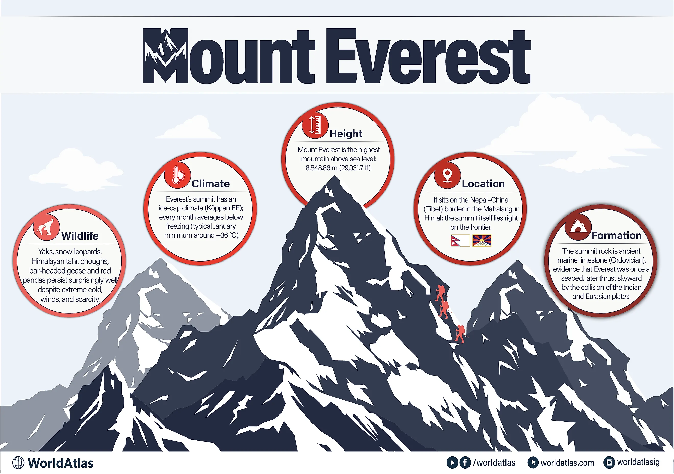
Located in the northern part of the Indian subcontinent in Asia, the Himalayas is a long mountain range that forms a formidable barrier between the Tibetan Plateau and the alluvial plains of the Indian subcontinent. Mount Everest, the world's highest peak, is located in the Mahalangur Himal subrange of the Himalayas. It lies on the boundary between the Tibet Autonomous Region of China and Nepal. Rising to an elevation of 8,848.86m, Mount Everest is the most prominent peak among the Seven Summits of the World.

Geography
It is believed that the Himalayan ranges were pushed upwards around 50 million years ago, as a result of the subduction of the Indian-Australian tectonic plate under the Eurasian Plate. During the early Miocene Epoch, the increased crunching force between the two collided plates further uplifted the Himalayas to greater heights. During the Pleistocene Epoch, the Greater Himalayas started to take their present form.
Geological studies have revealed that Mount Everest is made up of several layers of rock that have been folded back on themselves forming undulating structures or nappes. The rocks present on the lower elevations of the mountain are made up of metamorphic schists and gneisses that are topped by igneous granites. On the higher elevations, sedimentary rocks are found, that of marine origin, and are believed to be the remnants of the ancient Tethys Sea. Notable among these rocks is the Yellow Band, which is a limestone formation and is visible just beneath the summit pyramid. The rocks that makeup Mount Everest have been further subdivided by geologists into three units that are separated from each other by low-angle faults. From the base to the summit of Mount Everest, these rock units are the Rongbuk Formation, the North Col Formation, and the Qomolangma Formation.

The Qomolangma Formation stretches from the summit of the mountain down to the Yellow Band at an elevation of 8,600 meters. It consists of parallel laminated bands of dark grey or white Ordovician limestone, interspersed with beds of dolomite and argillaceous minerals. The Qomolangma Detachment distinguishes the Qomolangma Formation from the Yellow Band below it. The North Col Formation, which forms the majority of Mount Everest, is located at elevations ranging from 7,000 to 8,600 meters and is primarily made up of schist, phyllite, and marble layers. Beneath the North Col Formation lies the Rongbuk Formation, which constitutes the base of Mount Everest.
The slopes of Mount Everest are covered by several glaciers including the Kangshung Glacier, the Rongbuk Glaciers (East, Central, and West), the Pumori Glacier, and the Khumbu Glacier. Several rivers originate from these glaciers such as the Lobujya River which rises from the Khumbu Glacier, the Rong River which rises from the Rongbuk and Pumori glaciers, and the Kama River which originates from the Kangshung Glacier.
Climate

The warm daytime temperature in July averages only about -2°C at the summit of Mount Everest, while during January, the temperature at the summit averages -36°C and can fall as low as -60°C. Most of the precipitation falls as snow during the summer monsoon from late May to mid-September. The region also experiences sudden storms that can lead to a further drop in the temperatures. The layer of snow on Mount Everest fluctuates annually by 1.5 to 6m and is the highest during September and lowest during May. The mountain summit and the upper slopes of Mount Everest reach a higher level in the Earth’s atmosphere and therefore the amount of oxygen that is available here is about one-third to that in the sea level.
Flora and Fauna

The frigid temperatures, powerful winds, and insufficient oxygen inhibit plant growth and animal presence in this area. Consequently, there are very few native species. On the Nepal side of the international border, Mount Everest and its nearby valleys are part of Sagarmatha National Park. Established in 1976, this 1,243 sq. km park is home to plant species such as rhododendrons and Himalayan junipers in alpine habitats. Wildlife here includes the Himalayan jumping spider, yaks, Himalayan tahr, snow leopards, Himalayan black bears, and red pandas. Additionally, birds like bar-headed geese and yellow-billed choughs inhabit the region. In 1979, Sagarmatha National Park was recognized as a UNESCO World Heritage Site.
Brief History

Mount Everest has been revered as a ‘sacred place’ by the local Sherpa people for several centuries. The native people in Tibet refer to the mountain as “Chomolungma” which means “Holy Mother”, while in Chinese, the mountain is referred to as Zhumulangma Feng. The Government of Nepal and the local Nepali people refer to the mountain as “Sagarmatha” which means “the Head in the Great Blue Sky”.
In 1802, the British Government sent teams of surveyors to map the Indian subcontinent in an effort called the “Great Trigonometrical Survey.” In 1830, this surveying team was joined by geographer George Everest, who arrived in India to serve as surveyor-general. The following year, Everest sought a mathematician specializing in spherical trigonometry to assist with the survey, and appointed Radhanath Sikdar, an Indian mathematician and surveyor from Bengal, to this role. Colonel Andrew Scott Waugh succeeded Everest as the British Surveyor General of India in 1843. In 1847, he made important observations of a high peak located approximately 230 km from Kangchenjunga, then thought to be the world’s highest peak. One of Waugh’s subordinates, John Armstrong, also spotted this peak, designating it as peak “b.” In 1849, Waugh sent James Nicolson to the region for closer observations and to measure the height of peak “b.” Nicolson’s initial measurements indicated a height of about 9,200 m, significantly surpassing that of Kangchenjunga. Unfortunately, Nicolson contracted malaria and had to return home before completing his calculations. Michael Hennessy, another of Waugh’s assistants, subsequently named peak “b” Peak XV.
Using the trigonometric calculations based on Nicolson’s measurements the Indian Mathematician Radhanath Sikdar, calculated the exact height of the peak to be 29,000ft (8,839.2m). But Colonel Andrew Scott Waugh later added 2ft to make it appear at a more credible figure. In 1856, the official height of Peak XV was announced as 29,002 ft (8,839.8m). Sir Andrew Waugh named the Peak XV “Mount Everest” in the honor of his predecessor Sir George Everest. In 1865, the Royal Geographical Society officially declared Mount Everest as the world’s highest mountain.
Climbing History

Being the world’s mountain peak, Mount Everest attracts tourists and climbers from all around the world. On 29th May 1953, the New Zealander Sir Edmund Hillary and the local Nepali Sherpa Tenzing Norgay became the first men to have officially ascended the summit of Mount Everest. The ascent to this highest summit is considered to be extremely difficult and only experienced mountain climbers can ascend the mountain. It is estimated that every year more than 5,000 people attempt to summit the Mountain. As of 2017, it has been recorded that over 7,600 people have reached the Mountain summit and about 300 people have died in their attempts. There are two main climbing routes, one is the southeast ridge from Nepal and the other is the north ridge from Tibet. The climb to the highest summit takes about two months and the climbing season normally starts during mid-May just before the summer monsoon season. However, many obstacles are faced by the climbers which include avalanches, strong winds, altitude sickness, and the risk of frostbite.
Threats
In recent years, pollution in the Mount Everest area has significantly increased due to garbage left by climbers. This includes several tons of non-biodegradable waste such as empty oxygen tanks, tents, sleeping bags, broken climbing equipment, and food packaging. Insufficient solid waste management has resulted in human feces accumulating in the snow and on climbing trails, leading to pollution in nearby rivers. Additionally, bodies of over 280 climbers who perished while scaling Mount Everest remain unremoved. Furthermore, there are serious concerns regarding the deterioration of Mount Everest's fragile ecosystem due to the influx of climbers each year.