The Gambia River
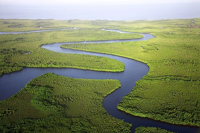
5. Description
Gambia, an important river of western Africa, arises from its source in the Fouta Djallon Plateau in the Republic of Guinea and flows westwards for a distance of 1,130 kilometers through the countries of Senegal and The Gambia before finally draining into the Atlantic Ocean, forming a "ria" (or a drained estuary) at its mouth. At various points along its course, the Gambia River splits into channels and then rejoins to form a number of islands in between. The Elephant Island and the MacCarthy Island are the largest islands in and along the river. The Sandougou and the Sofianiama are two important tributaries of the Gambia. The Kunta Kinteh Island, 30 kilometers from the mouth of the river, is historically important for its association with the West African slave trade, and has been designated as a UNESCO World Heritage Site
4. Historical Role
It is estimated that sophisticated settlements already existed in the region around the Gambia River by about 500 AD, and shortly thereafter the river became an important trade route between the Saharan Arabs and the tribes to the south. The Empire of Mali dominated the region in the 13th Century, to be later replaced by the Mandinka settlements. The West African slave trade was established when the Portuguese built settlements on the Gambia River during the 16th Century. The Portuguese control over the region had declined by the 1650s, when the English, the French, and the Dutch began exerting their own influences along the river. Native Africans were captured and sold as slaves for about 150 years thereafter. This lasted until 1807, when the British abolished the slave trade in the region.
3. Modern Significance
The most important function of the Gambia River in modern times is its use as a waterway for transporting cargo, people, and mail across various distances. Ferry services operate along the course of the river, allowing north-south river crossings connecting the northern and southern parts of the nation of The Gambia. The plain lands towards the middle of the Gambia River Basin support the cultivation of rice, millet, and sorghum, while peanuts and groundnuts are grown in the higher slopes of the river valley. Human settlements are thus more common in these cultivated areas. The river also supports commercial fisheries, and abounds in such fish species as the Tiger-fish, Characins, African Pike, snappers, Lady-fish, and Thread-fin Salmon. Currently, it also serves as a popular tourist spot for traveling sports fishermen.
2. Habitat and Biodiversity
The vegetation pattern of the Gambia River Basin varies from its mouth to its source. Mangrove forests stretch inland for about 97 kilometers from the mouth of the river. The middle of the course of the river supports freshland swamps and salt flats, and these serve as ideal breeding places for a large number of insects. Salt mud flats, Sudanian-Guinean riverine forests, and tall grasslands are also found along the course of the river. Around 1,500 plant species, 80 mammalian species, and 330 avian species inhabit the Gambia River Basin. 150 species of freshwater fish and 26 species of reptiles are also supported by the riverine habitat. A large number of semi-aquatic animal species, including reptilian crocodiles and mammalian Spotted Neck otters and hippopotamuses, inhabit the waters of the Gambia River. African Sacred ibises, Long-crested eagles, Yellow-billed storks, and Grass warblers are some of the bird species commonly sighted in the region.
1. Environmental Threats and Territorial Disputes
High rates of poaching prevail in the Gambia River Basin, and certain species of crocodiles, manatees, and hippopotamuses have almost been hunted to extinction in The Gambia. Currently, there is plan to construct a dam on the river at the border between Senegal and Guinea with the potential to generate 400 Gigawatt-hours (GWh) of electricity annually. However, the proposed dam also threatens to damage the sediment balance of the river, destroy the mangrove swamps, and adversely affect the life cycle of the aquatic species of the river. Global warming, triggering higher average temperatures and lower rainfall in the near future, could also lead to higher rates of sedimentation in the river, higher rates of evaporation, and greater proportional extractions of water from the river to meet the needs of the settlers along its course. This will further endanger the lives of the flora and fauna in the river habitat, as well as the growing human populations living on and beyond its banks.


