What Is The Struve Geodetic Arc?
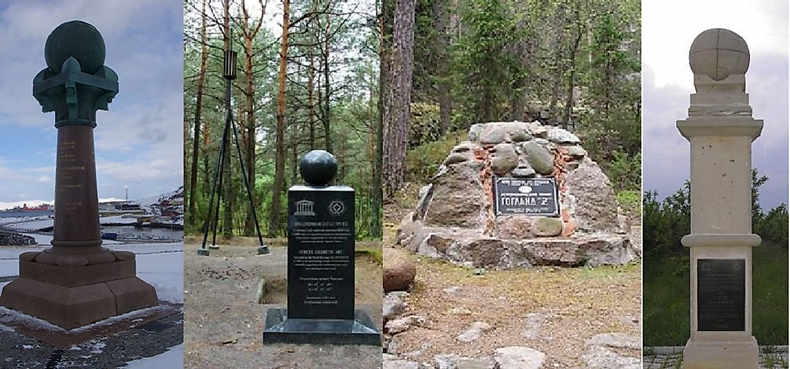
The Struve Geodetic Arc is a series of survey triangulation points that extend to the Black Sea after starting from Hammerfest in Norway. Along the way, it passes trough ten other countries covering a total distance of 2,820 kilometers. They represent survey points that were mapped between 1816 and 1855 during surveys performed by the German astronomer Friedrich Georg Wilhelm Struve. The survey points helped to ascertain the precise size and shape of the earth. They also represented the first exact measuring along the part of the Meridian and marked the first step in developing of the subject of Earth science and topographical mapping. It is a fantastic illustration of a scientific partnership between scientists from different countries and cooperation among the monarchs for a scientific cause. The very first arc was composed of 258 triangles and 265 station points marked by drilling a small hole in rock surface, building of obelisks, construction of Cairns, or a cross symbol.
History
Over the course of several centuries, man had always been fascinated with the shape and size of the planet earth, and calculating accurate measurements of such became one of the most significant problems for philosophers starting from the 4th Century BC and onward. In the 16th Century, a new measuring system known as the Triangulation Approach was developed that improved the ability to determine the size and shape of the world. According to the new approach, it involved the creation of arcs that extended for hundreds and thousands of kilometers long using chains of triangles. Before Struve Geodetic Arc was developed, there was an arc of about 2400 kilometers that had been developed in India that was completed in 1845 by Lambton and Everest, and there was another shorter arc in Lithuania that had been developed by Carl Tenner. Struve, a German astronomer, was working at Dorpat University now the University of Tartu in Estonia set out to map the arc along the longitude line of Meridian and would pass through the University’s observatory center. The new arc outlined by Struve connected the earlier shorter arcs in the south that were created by Tenner to create a longer Arc that would be known as the Struve Geodetic Arc. This long arc would now extend from Fuglenaes near Hammerfest in the Arctic Ocean and Staro-Nekrassowka near Ismail on the shores of the Black sea covering a distance of 2,820 kilometers.
Survey Point Locations
Presently, the properties including these survey points are inscribed on the United Nations Educational, Scientific, and Cultural Organization (UNESCO) World Heritage Site list, and these cover 34 of the original station points that were mapped by Struve. Four points are in Norway, seven are in Sweden, six are in Finland, two are in Russia, three are in Estonia, three are in Lithuania, two are in Latvia, four are in Ukraine, five are in Belarus, and one is in Moldova. The markings along the arc take different forms which include small holes made on the rocks surfaces and some were filled with lead, some were marked with engravings of a cross, constructed monuments to commemorate the arc, and the point, others with rock structures.
Significance
The Struve Geodetic Arc is an amazing illustration of an interchange of human values and scientific collaboration that transcends international boundaries, and serves as an outstanding technological achievement. The Struve Geodetic Arc was the first measurement along part of the meridian that helped to establish the exact size and shape of the earth and a significant milestone in the development of earth sciences discipline. It was also an exemplary interchange of human values through scientific collaboration across borders among the scientists and monarchs for a scientific cause. The measurements of the arc and the results was a long term inquisitive knowledge that dates back to the time of Isaac Newton who argued the world was not an exact sphere and so the curious knowledge to establish the exact shape and size of the earth.