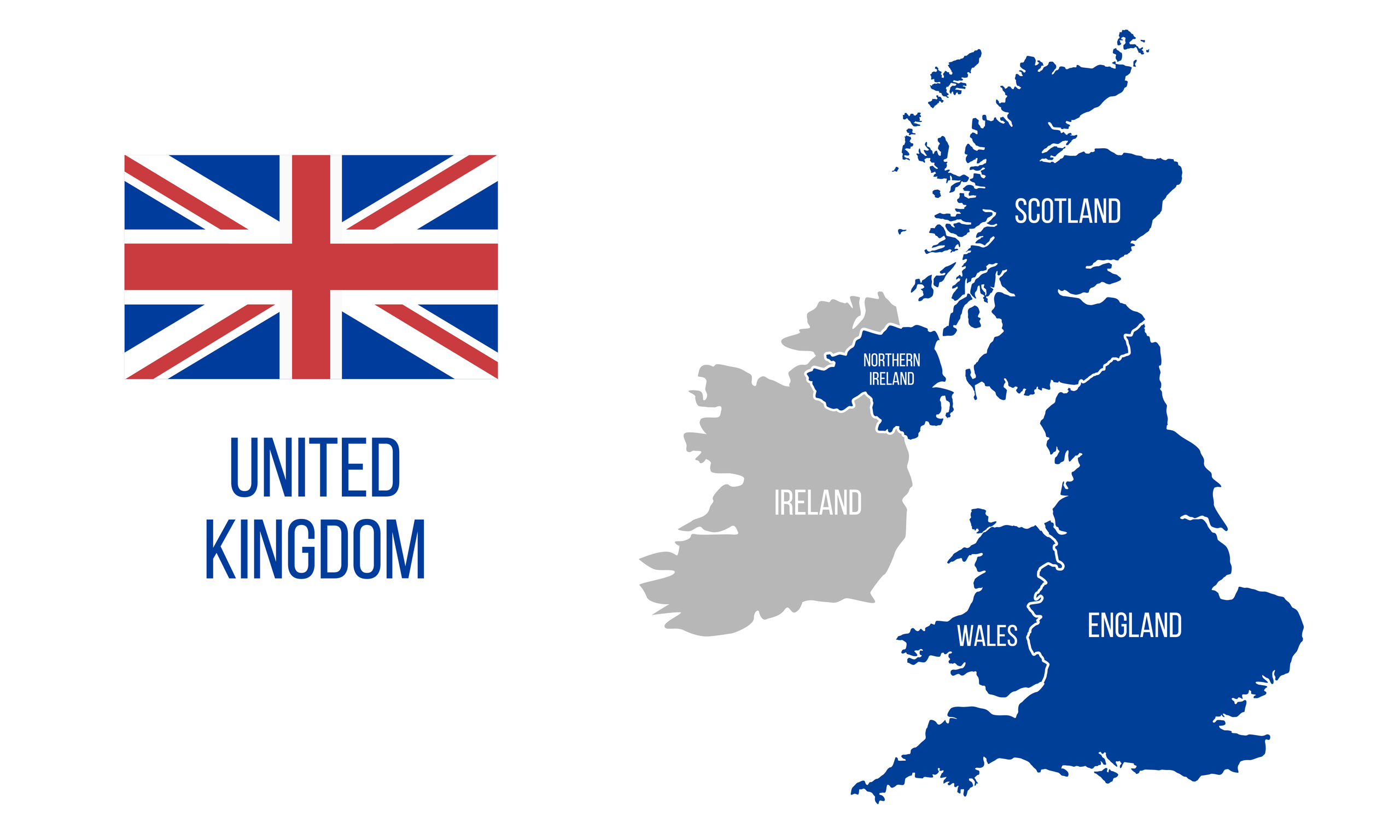
Constituent Countries Of The United Kingdom
- The United Kingdom has 4 constituent countries, England, Wales, Scotland, and Northern Ireland.
- England is the largest and most populous country of the United Kingdom. More than 80% of the UK's population lives in England.
- Scotland, Wales, and Northern Ireland have various degrees of home rule, meaning that they have some control over their domestic affairs.
- There are movements for independence in Scotland, Wales, and Northern Ireland.
The United Kingdom has four constituent countries, England, Wales, Scotland, and Northern Ireland. The UK came together over several centuries. Historically, the kingdom and its politics have been dominated by England, as it has always been the most powerful. Even today, England dominates the UK politically, linguistically, and culturally, as it is the largest, and by far, the most populous constituent country in the union. Nevertheless, the UK’s other constituent countries still maintain vibrant cultures and traditions.
Contents:
How Was The United Kingdom Formed?
The first countries to come together were England and Wales. In 1536, Wales was formally merged with England, through an Act of Union. Less than a century later, in 1603, the Union of the Crowns took place, which united the royal houses of England and Scotland. It was followed by the Union of the Parliaments in 1707, when the parliament of Scotland dissolved itself and the parliament of England, based in London, became the parliament for all of Great Britain. In 1801, the parliament of Ireland, which had been under English rule almost continuously since the 12th century, formally joined Great Britain through an Act of Union. Thus, the United Kingdom of Great Britain and Ireland came into being. Ireland, except the northern part, which became Northern Ireland, would eventually break away from the UK and become independent in 1921. Hence, the UK is now known formally as the United Kingdom of Great Britain and Northern Ireland.
England

The story of England begins with the arrival in Great Britain of the Anglo-Saxons, beginning in the 5th century CE. The Anglo-Saxons were Germanic tribes from northern continental Europe. In the 10th century, the Anglo-Saxons united under one ruler, King Ethelstan, who is regarded as the first King of England. He ruled from 924 to 939 CE. Several different dynasties have ruled England over more than a millennium. A pivotal moment in English history took place when the English navy defeated the Spanish Armada in 1588, marking the beginning of England’s naval supremacy. Shortly thereafter, England began establishing outposts and settlements all over the globe. England’s history as a country unto itself ended in 1603, when Queen Elizabeth I chose to anoint King James VI of Scotland as her successor in what was known as the Union of the Crowns. From then onward, England was part of the country known as Great Britain.

Today, England is the dominant political, economic, and cultural force in the UK. This dominance is reflected in the fact that when people around the world talk about the UK, they often refer to it simply as England. Of the estimated 67 million people that live in the UK, about 56 million live in England. Most of the UK’s economy is also based in England. In fact, as of 2018, England’s economy was worth approximately 1.8 trillion British Pounds, whereas the next leading economy, Scotland, was worth just an estimated 161 billion Pounds. Arguably, England’s most dominant force in the UK is the English language, which has managed to all but replace other languages indigenous to the UK, such as Welsh, Scottish Gaelic, and Irish Gaelic.
Wales

Unlike England and Scotland, Wales was never a single nation-state. Rather, it was divided among several kingdoms. Over two centuries following the conquest of England by the Normans, the English gradually seized more and more Welsh territory. The last independent Welsh kingdom was conquered by England’s King Edward I in 1283. From then on, Wales was a colony of England. In 1536, the Act of Union uniting Wales with England was passed. Industrialization came rapidly to Wales in the 18th century. In fact, Wales was once one of the most important industrial areas in the world.

In the mid-20th century, Welsh nationalism led to measures that recognized the nationhood of the Welsh people, such as giving the Welsh language legal status and adopting an official flag. Efforts to revive the Welsh language have been ongoing for the last few decades. At the end of the 1980s, Welsh was made a compulsory subject in schools. In 1999, Wales was given home rule, including a parliament of their own, which allowed the Welsh people some control over their domestic affairs. Today, there is a movement for Welsh independence, though it is not as strong as similar movements in Scotland and Northern Ireland.
Scotland

The forerunner of the Kingdom of Scotland was the Kingdom of Alba, ruled by Macbeth in the mid-11th century. This is the same Macbeth immortalized by Shakespeare’s play of the same name. In the late 13th and early 14th centuries, England attempted to conquer Scotland, but the Scots rebelled successfully to retain their independence. In 1603, King James VI of Scotland was made King James I of England, merging the two royal regimes. This was known as the Union of the Crowns. In 1707, the Scottish parliament dissolved itself, and a parliament unifying the representatives of Scotland and England was proclaimed in London, thus completing the Union of the Parliaments. Industrialization came rapidly to Scotland in the 19th century. The country became a mecca for ship-building, steel works, and iron foundries.

In 1967, oil drilling began in the North Sea, giving Scotland a vital resource for future prosperity. In 1999, Scotland was given a wide degree of autonomy, when its parliament convened for the first time since the Union of the Parliaments. During the same decade, Scottish culture and history gained worldwide prominence through movies like Braveheart and Trainspotting. Scotland’s artists, musicians, and authors were also in high demand. In 2014, Scottish voters narrowly rejected independence from the UK in a referendum. Nevertheless, the Scottish independence movement is now stronger than ever, and many people believe that another referendum would lead to a vote in favor of independence.
Northern Ireland

Northern Ireland was cut off from the rest of Ireland in 1921, when the British government agreed to create the Irish Free State in response to the demands of the Irish independence movement. But as part of this arrangement, six counties in the northern Ulster region of the island, in which most of the population was Protestant, were split off from the rest of Ireland and remained part of the UK. These counties would form what would be called Northern Ireland. For the next few decades, Northern Ireland would remain relatively quiet. But in 1966, violence broke out between Irish Catholics, who wanted to unite Northern Ireland with the predominantly Catholic Republic of Ireland, and Protestant Unionists, who wanted Northern Ireland to remain part of the UK. Thus began the period known as The Troubles. Violence would continue for decades. Then, in 1994, paramilitary groups on both sides began a ceasefire. Four years later, the Good Friday Agreement was signed, giving the country an autonomous local government and power-sharing arrangements between the Irish Catholics and Protestant Unionists. Since then, a relative peace has taken hold in the country. Nevertheless, tension still remains.

A new paradigm has emerged in the conflict recently, as the UK voted to leave the European Union in 2016. Most voters in Northern Ireland, however, voted to remain part of the EU, since doing so meant the continued free movement of goods and services between Northern Ireland and the Republic of Ireland. Much to the relief of many in Northern Ireland, a compromise was reached under which the border between Northern Ireland and the Republic of Ireland would remain customs-free once the UK formally left the EU in 2021, but new customs checks would be introduced for the movement of goods between Northern Ireland and the rest of the UK. As of late, some Unionists have expressed their displeasure at the aforementioned new customs arrangements, as they feel more estranged from the rest of the kingdom.
Constituent Countries Of The United Kingdom
| Rank | Constituent country | Capital | Population | % share of population | Area in km2 | % share of area | Pop. density (per km2) |
|---|---|---|---|---|---|---|---|
| 1 | England | London | 56,286,961 | 84% | 130,279 | 54% | 432.05 |
| 2 | Northern Ireland | Belfast | 1,893,667 | 3% | 13,562 | 5.5% | 139.63 |
| 3 | Scotland | Edinburgh | 5,463,300 | 8% | 77,933 | 32% | 70.10 |
| 4 | Wales | Cardiff | 3,152,879 | 5% | 20,735 | 8.5% | 152.06 |


