The 36 National Natural Landmarks of California
The United States National Natural Landmarks (NNL) is a program that identifies and encourages the management, conservation, and rehabilitation of natural history in the US. The program identifies the geological and biological features in private and public ownership. The main aim of the program is to encourage and support individual and organization efforts in preserving sites that illustrate the ecological and geological history of the country. The program also seeks to encourage the public to appreciate natural heritage. There are 599 national natural landmarks in the country spread across 48 states, and the territories of Virgin Islands, Puerto Rico, Guam, and American Samoa. Delaware and Louisiana are the only states without a national natural landmark. The federal, state, county, or municipal governments manage about one-half of the landmark sites. One-third is privately owned while the rest is owned and managed by a public-private corporation. A site qualifies as NNL because it contains the remnants of a specific geological, ecological, or biological feature. There are thirty-six National Natural Landmarks in California which include faults, desert parks, and extinct ice age animals and plants.
National Natural Landmarks of California
Elder Creek
Elder Creek is the oldest NNL in California. Elder Creek is a stream of the Sacramento
River. It is located in Tehama County.
The stream originates from the Mendocino National Forest. It was designated in 1964 as the oldest National Natural
Landmark in California. The privately owned site covers an area of 2,905 acres.
Elder Creek is among the few undisturbed watersheds in the country. It consists
of a forest with Douglas
fir, deciduous trees, and broadleaf evergreens.
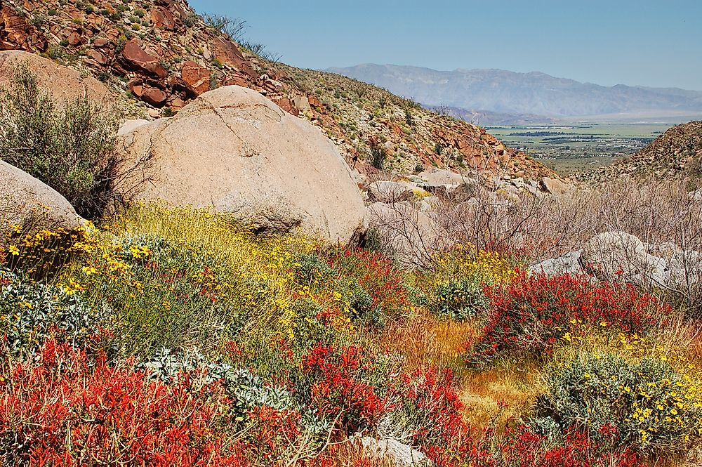
Anza-Borrego Desert State Park
Anza-Borrego Desert State Park is the largest NNL in California, alongside being the largest desert state park and the second largest park in the United States. The park occupies 622,810 acres of the Colorado Desert. It was designated an NNL monument in 1974. The park’s habitat is part of the Colorado Desert ecosystem that includes woodlands, and California montane ecoregion. It contains bajadas, rock formation, desert washes, arid landscapes, and colorful badlands. Natural oases and springs support the only native palm trees in California.
Eureka Dunes
The Eureka Dunes is the tallest NNL in California. Eureka Dunes occupies the southern part of Eureka Valley in Inyo County. The dunes cover an area of 4,544 acres. They rise to a height of 680 feet making them the tallest dunes in the great basin. The dunes were designated a National Natural Landmark in 1983. The dunes’ ecosystem is home to unique and protected plant species including the eureka dune grass and the eureka evening primrose.
Designation and Ownership
The Federal government wholly owns ten of the thirty-six NNLs; nine are owned by the state governments, while ten more are private properties. The rest are owned by joint ownership between the three parties. A majority of the sites were designated NNLs between 1964 and 1987, Irvine Ranch Natural Landmarks is the only park that was designated between 1988 and 2011, while Lake Shasta Caverns was designated in 2012 as the newest NLL.
The 36 National Natural Landmarks of California
| Rank | Name | Date | County | Ownership |
|---|---|---|---|---|
| 1 | Amboy Crater | 1973 | San Bernardino | Federal |
| 2 | American River and Phoenix Park Vernal Pools | 1976 | Sacramento | County/private |
| 3 | Año Nuevo State Reserve | 1980 | San Mateo | State |
| 4 | Anza-Borrego Desert | 1974 | Imperial, Riverside, San Diego | State |
| 5 | Audubon Canyon | 1968 | Marin | Private |
| 6 | Black Chasm Cave | 1976 | Amador | Private |
| 7 | Burney Falls | 1984 | Shasta | State |
| 8 | Cima volcanic field | 1973 | San Bernardino | Federal |
| 9 | Cosumnes River Preserve | 1976 | Sacramento | Private/Federal |
| 10 | Deep Springs Marsh | 1975 | Inyo | Private |
| 11 | Dixon Vernal Pools | 1987 | Solano | Private |
| 12 | Elder Creek | 1964 | Mendocino | Private |
| 13 | Emerald Bay | 1968 | El Dorado | State |
| 14 | Eureka Dunes | 1983 | Inyo | Federal |
| 15 | Fish Slough Area of Critical Environmental Concern | 1975 | Inyo, Mono | Federal/state/municipal |
| 16 | Guadalupe-Nipomo Dunes | 1974 | San Luis Obispo | Federal/state/private) |
| 17 | Imperial Sand Hills | 1966 | Imperial | Federal |
| 18 | Irvine Ranch Natural Landmarks | 2006 | Orange | State/county/municipal |
| 19 | Lake Shasta Caverns | 2012 | Shasta | Private |
| 20 | Miramar Mounds | 1972 | San Diego | Federal |
| 21 | Mitchell Caverns and Winding Stair Cave | 1975 | San Bernardino | State |
| 22 | Mt. Diablo State Park | 1982 | Contra Costa | State |
| 23 | Mount Shasta | 1976 | Siskiyou | Federal |
| 24 | Pixley Vernal Pools | 1987 | Tulare | Private |
| 25 | Point Lobos | 1967 | Monterey | State |
| 26 | Pygmy Forest at Jug Handle State Natural Reserve | 1969/1973 | Mendocino | State |
| 27 | Rainbow Basin | 1966 | San Bernardino | Federal |
| 28 | La Brea Tar Pits (Rancho La Brea) | 1964 | Los Angeles | Municipal |
| 29 | San Andreas Fault | 1965 | San Benito | Private |
| 30 | San Felipe Creek Area | 1974 | Imperial, San Diego | Federal/state |
| 31 | Sand Ridge Wildflower Preserve | 1984 | Kern | Private |
| 32 | Sharktooth Hill | 1976 | Kern | Private |
| 33 | Tijuana River Estuary | 1973 | San Diego | Federal/state/municipal |
| 34 | Torrey Pines State Reserve | 1977 | San Diego | State |
| 35 | Trona Pinnacles | 1967 | San Bernardino | Federal |
| 36 | Turtle Mountain | 1973 | San Bernardino | Federal |


