Does Canada Have States?
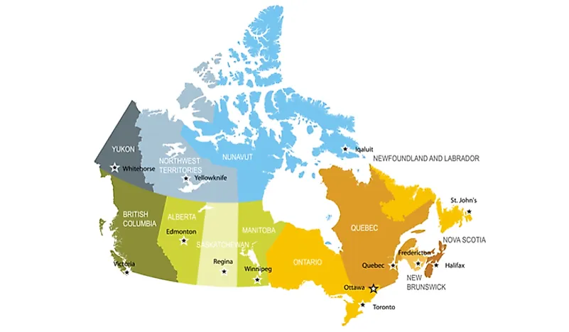
Canada is the second largest country in the world in terms of land area. Its vast land is not divided into states but is instead divided into provinces.
Canada’s provinces and territories can be broadly classified into four categories namely Northern Canada, Atlantic Canada, Central Canada, and Western Canada. The Canadian provinces include Ontario, Alberta, Manitoba, Quebec, New Brunswick, British Columbia, Saskatchewan, Prince Edward Island, Nova Scotia, and Newfoundland and Labrador. Canada’s territories include Nunavut, Northwest Territories, and Yukon.
Canada’s Largest Territory
Nunavut is the largest administrative unit in Canada. It is one of Canada’s three territories and is situated on the northernmost region of Canada. The territory of Nunavut occupies a total area of 787,155 square miles. Despite being the largest territory in Canada, Nunavut is one of the least populous regions in the country. The entire territory has a population of close to 36,000 residents. Nunavut territory has the northernmost permanent residence in the world only 508 miles away from the North Pole.
Canada’s Smallest Province
The smallest administrative unit in Canada is the province of Prince Edward Island. The province is comprised of Prince Edward Island and numerous other small islands. The province occupies a total land area of 2,195 square miles. Prince Edward Island is home to approximately 153,200 residents. Agriculture is the main economic activity in Prince Edward Island, and the province supplies 25% of potatoes in Canada.
Canada’s Most Populous Provinces
The Province of Ontario has the highest concentration of people in Canada. The province is home to an estimated 14.3 million residents which translates to 38% of Canada’s population. Canada’s capital city – Ottawa – is in the province of Ontario. Additionally, Ontario has Canada’s most populous city, Toronto. Most residents in Ontario province are concentrated in the southern region. The province occupies a total area of 415,598 square miles. Ontario is classified as a manufacturing center in Canada. The province accounted for approximately 52% of manufactured exports in 2004.
Canada’s Least Populous Territory
The territory of Yukon has the least population in Canada. The administrative unit has an estimated population of 38,900 residents. The territory is on the western end of Canada. It occupies a total area of 186,272 square miles. Most of the territory has a subarctic climate which explains the low population in the region. Mining, manufacturing, and tourism are some of the economic activities in Yukon.
System of Government
Canada has a federal parliamentary system of government with a constitutional monarchy. The head or the chief of state is the monarch (Queen Elizabeth II) and is represented by the Governor General in the country. The role of the monarch is typically ceremonial. On the other hand, the head of government is the prime minister. The monarch appoints the Governor General with the advice of the prime minister and servers for a term of 5 years. After the legislative elections, the majority coalition or the majority party leader in the House of Commons is chosen as the prime minister by the Governor-General.


