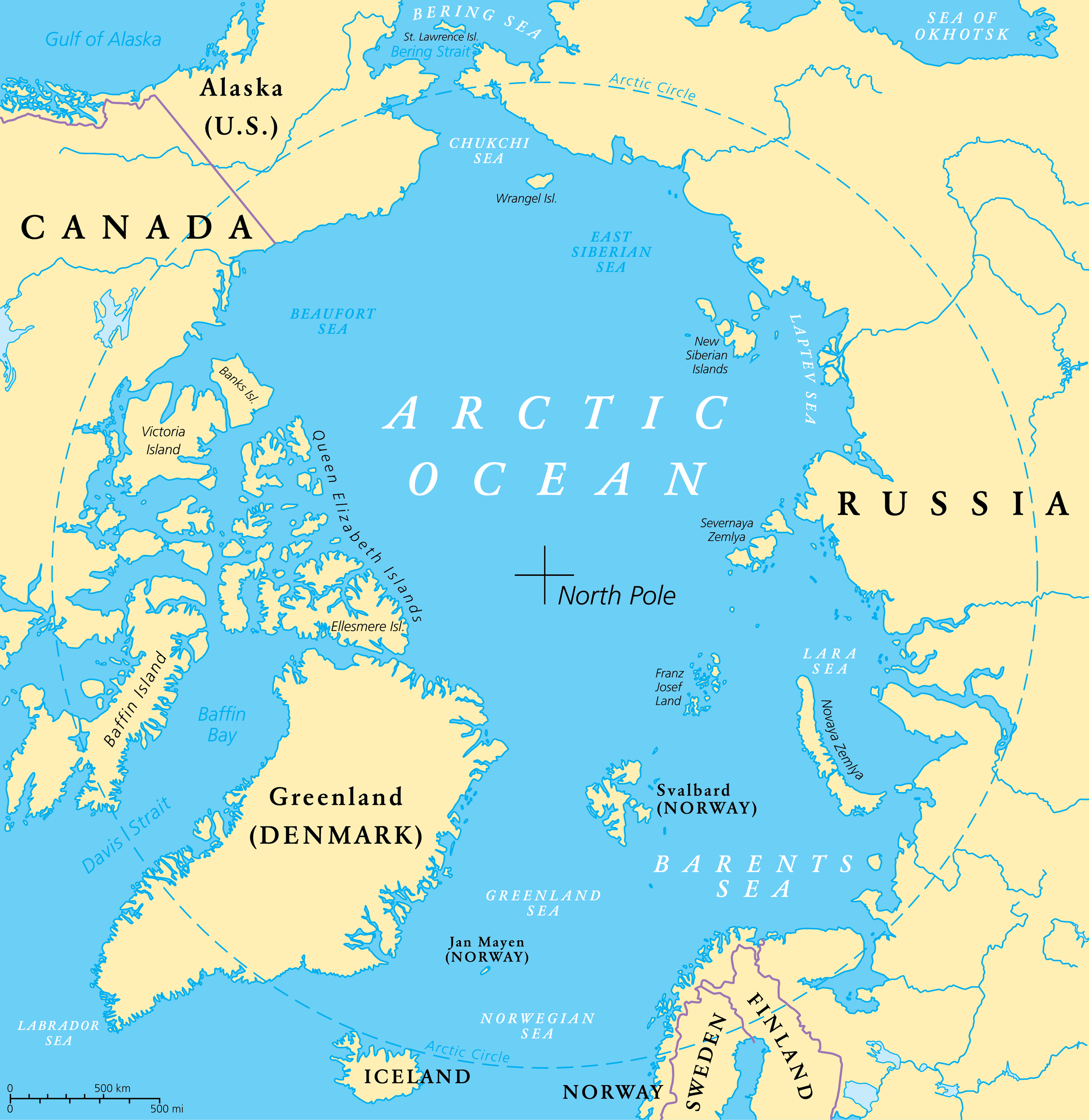
The Marginal Seas Of The Arctic Ocean
The Arctic Ocean is the smallest, shallowest, and northernmost of Earth's five oceans, centered roughly on the North Pole and ringed by the upper coasts of North America, Europe, and Asia. Much of it stays locked beneath sea ice for part or all of the year, though that ice cover has thinned and shrunk markedly in recent decades. It also carries the lowest salinity of any ocean, diluted by the enormous volume of freshwater that the great Arctic rivers pour into it. Around its edges, where open water meets the continents, the ocean breaks into a series of marginal seas, along with the bays, gulfs, and straits that lace the polar coastline. Together they are where most of the region's shipping, fishing, and sea-ice formation actually happen. The major ones are mapped out below.
The Arctic's Seas at a Glance
Figures vary between sources, since many of these seas are partly ice-covered and loosely bounded, but the approximate dimensions give a sense of how they compare.
| Sea | Location | Approx. area | Depth |
|---|---|---|---|
| Barents Sea | Off northern Norway and Russia | ~1,400,000 km² | avg ~230 m |
| Norwegian Sea | Northwest of Norway | ~1,380,000 km² | max ~3,970 m |
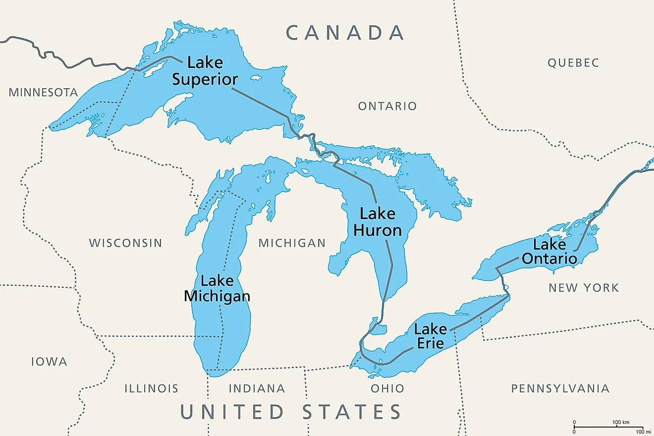
| Hudson Bay | Northeastern Canada | ~1,230,000 km² | max ~270 m |
| Greenland Sea | Between Greenland and Svalbard | ~1,205,000 km² | max ~4,800 m |
| East Siberian Sea | Off northeastern Siberia | ~987,000 km² | mostly under 50 m |
| Kara Sea | North of western Siberia | ~926,000 km² | avg ~130 m |
| Laptev Sea | Off the central Siberian coast | ~700,000 km² | max ~3,385 m |
| Chukchi Sea | Between Siberia and Alaska | ~595,000 km² | avg ~80 m |
| Beaufort Sea | North of Alaska and NW Canada | ~476,000 km² | max ~4,680 m |
| White Sea | Inlet off northwestern Russia | ~90,000 km² | max ~340 m |
Chukchi Sea

The Chukchi Sea spreads across roughly 595,000 square km between Alaska's Point Barrow to the east and the Long Strait off Wrangel Island to the west. At its southern end the Bering Strait links it to the Bering Sea and the Pacific Ocean, making it the gateway through which Pacific water enters the Arctic. It is a shallow shelf sea, and its waters support walrus, polar bears, and seabird colonies. Once frozen for most of the year, the Chukchi now opens to far more ice-free water each summer, which has drawn growing attention from shippers and energy companies alike.
Beaufort Sea

Lying north of Alaska, Yukon, and the Northwest Territories, the Beaufort Sea covers about 476,000 square km and plunges to more than 4,600 meters where its narrow continental shelf drops into the deep Canada Basin. It stays frozen for much of the year, although the ice season is shortening. The sea hosts one of the world's largest summer gatherings of beluga whales, which congregate in the Mackenzie River estuary, and its seabed has long attracted oil and gas interest. It also marks a long-disputed maritime boundary between the United States and Canada.
Amundsen Gulf
At the western mouth of Canada's Northwest Passage sits the Amundsen Gulf, a body of water in the Northwest Territories stretching about 400 km in length. It separates Banks and Victoria Islands from the mainland and teems with marine life, including beluga whales, ringed and bearded seals, and several species of Arctic fish. The gulf is named for the Norwegian explorer Roald Amundsen, the first to navigate the entire Northwest Passage.
Prince Gustav Adolf Sea
Set among the islands of the Canadian Arctic Archipelago in the Qikiqtaaluk Region of Nunavut, the Prince Gustav Adolf Sea is one of the more obscure waters on this list. It opens northward into the Arctic Ocean and connects southward through the Maclean Strait and the Byam Martin Channel. Ringed by islands and frozen for most of the year, it sees little traffic beyond research and the occasional Arctic expedition.
The Northwest Passage
The Northwest Passage is less a single body of water than a network of sea routes threading the Canadian Arctic Archipelago to connect the Atlantic and Pacific Oceans. The Prince Gustav Adolf Sea and the Amundsen Gulf both lie along it. Sought for centuries as a shortcut between Europe and Asia, the passage was long choked by ice; as Arctic sea ice retreats, it has become navigable for longer stretches each year, reviving commercial and strategic interest in the route.
Hudson Strait
The Hudson Strait connects Hudson Bay with the Atlantic Ocean and the Labrador Sea, separating the Nunavik region of Quebec from Baffin Island to the north. It runs roughly 750 km in length and reaches a maximum width of about 240 km. Strong tides and drifting ice make it a challenging passage, yet it serves as the vital marine corridor for ships reaching the ports of Hudson Bay.
Hudson Bay

Hudson Bay is an immense, shallow inland sea in northeastern Canada, covering about 1,230,000 square km yet reaching a maximum depth of only around 270 meters. Its vast drainage basin gathers water from several Canadian provinces and a slice of the north-central United States. By most definitions it counts as an arm of the Arctic Ocean, and it freezes over each winter. The town of Churchill, on its western shore, is famous as a gathering point for polar bears waiting for the ice to return.
James Bay
The James Bay is the shallow southern extension of Hudson Bay, reaching down toward the heart of Canada. It is the homeland of the James Bay Cree and the site of one of the largest hydroelectric developments on Earth, the James Bay Project, whose dams on the region's rivers supply power across Quebec and beyond. Its marshy coast and many islands make it an important stopover for migrating waterfowl.
Lincoln Sea
The Lincoln Sea lies at the very top of the map, between Ellesmere Island's Cape Columbia and northern Greenland's Cape Morris Jesup. Covering roughly 64,000 square km, it is buried under some of the oldest and thickest sea ice anywhere on the planet, frozen year-round. The Canadian Forces Station Alert, the northernmost permanently staffed settlement in the world, sits on its shore.
Wandel Sea
Off the northeastern coast of Greenland lies the Wandel Sea, sometimes called the McKinley Sea. Ice blankets it for much of the year, and the waters just north of it stay frozen even through summer. It sits within the so-called Last Ice Area, the stretch of the Arctic expected to hold onto its multiyear sea ice the longest as the region warms.
Queen Victoria Sea
The Queen Victoria Sea is a small, ice-bound body of water between the northeastern reaches of the Svalbard archipelago and the northwestern edge of Franz Josef Land. Frozen for most of the year and bordered to the south by islands such as Victoria Island and Kvitøya, it is a minor and seldom-referenced sea on the European side of the Arctic.
Greenland Sea

The Greenland Sea sits between Greenland to the west and the Svalbard archipelago to the east, with Iceland and the Norwegian Sea marking its southern limit and the Fram Strait opening to the Arctic Ocean in the north. Covering about 1,205,000 square km and reaching depths near 4,800 meters, it straddles the boundary between the Arctic and the Atlantic, and oceanographers disagree on which it belongs to. Either way, it is one of the planet's key engines of deep-water formation, where cold, dense surface water sinks and helps drive global ocean circulation.
Norwegian Sea

Spanning roughly 1,380,000 square km northwest of Norway and reaching nearly 4,000 meters deep, the Norwegian Sea sits between the Greenland Sea and the North Sea and is fenced off from the open Atlantic by a submarine ridge. It is usually grouped with the Nordic Seas on the Arctic-Atlantic frontier, and many oceanographers class it as part of the Atlantic rather than the Arctic proper. Unlike its frozen neighbors, it stays ice-free year-round, kept warm by the Norwegian Current, which makes it a rich and heavily worked fishing ground.
Barents Sea

The Barents Sea lies off the northern coasts of Norway and Russia and, at about 1,400,000 square km with an average depth near 230 meters, is comparatively shallow for its size. Warm Atlantic water flowing in keeps its southwestern reaches largely free of ice, and the sea ranks among the most productive fisheries in the region while also being a major frontier for oil and gas exploration. Two smaller waters are considered parts of it: the Pechora Sea in its southeastern corner, and the White Sea, an almost landlocked southern inlet off northwestern Russia that connects through a narrow strait and freezes solid each winter around the historic port of Arkhangelsk.
Kara Sea

Named after the Kara River, the Kara Sea sits north of Siberia between the Barents Sea and the Laptev Sea, with Novaya Zemlya and the Kara Strait dividing it from the former and the Severnaya Zemlya archipelago from the latter. It covers roughly 926,000 square km, averages only about 130 meters deep, and remains frozen for some nine months of the year. Two of the largest rivers on Earth, the Ob and the Yenisei, empty into it, flooding it with freshwater and sediment.
Laptev Sea

The Laptev Sea is hemmed in on three sides by land: the northern Siberian coast to the south, the Taimyr Peninsula and Severnaya Zemlya to the west, and the New Siberian Islands to the east, opening into the Arctic Ocean only to the north. It covers about 700,000 square km and drops to roughly 3,385 meters at its deep northern margin. Bitterly cold and sparsely inhabited, it is one of the Arctic's great "ice factories," freezing in winter and then exporting vast quantities of sea ice out across the polar basin. The mighty Lena River builds an enormous delta along its shore. It takes its name from the Russian explorers Dmitry and Khariton Laptev.
East Siberian Sea

Stretching between the New Siberian Islands to the west and Wrangel Island and Cape Billings to the east, the East Siberian Sea covers roughly 987,000 square km and ranks among the least-studied waters in the Arctic. It is extremely shallow, with depths mostly under 50 meters, and endures one of the harshest climates anywhere, staying frozen for the great majority of the year. Low temperatures, weak salinity, and scant nutrients leave it with little marine life compared with the seas to its west.
One Ocean, Many Seas
For all that they share a frozen ceiling, the marginal seas of the Arctic are far from interchangeable. Some, like the Barents and Norwegian, stay open and teem with fish; others, like the East Siberian and Lincoln, are shallow, ice-choked, and nearly empty of life. A few sit so squarely on the Arctic-Atlantic boundary that experts still argue over where they belong. What ties them together is change: as the sea ice that long defined this ocean continues to retreat, these once-remote waters are becoming some of the most closely watched in the world.