Maps of Dominican Republic

The Dominican Republic, occupying the eastern two-thirds of the island of Hispaniola, is the 2nd largest country in the Caribbean. It has an area of 48,671 sq. km (18,792 sq mi).
As observed on the physical map of the country above, Dominican Republic is mountainous in the central and west, while extensive lowlands dominate the southeast. There are four significant mountain ranges in the Dominican Republic, with the rugged Cordillera Central – the highest and largest range. It include Pico Duarte, the country’s highest point, and the highest point in the Caribbean. Several peaks there exceed 5,000 ft. Lesser ranges cover the northern coastlines and the south-western border areas with Haiti. Compared to the tropical conditions in the west, the lowlands of the southeast are exceptionally dry, with very little usable plant growth.
There are many small offshore islands and cats that are part of the Dominican territory. The two largest islands near shore are Saona, in the southeast, and Beata, in the southwest.
Lake Enriquillo in the far southwest is the largest lake. It’s a saltlake at 131ft (40m) below sea level, the lowest point in the Caribbean. The largest river is the Yaque del Norte. Dozens of smaller rivers and streams drain the country from the mountains to the sea.
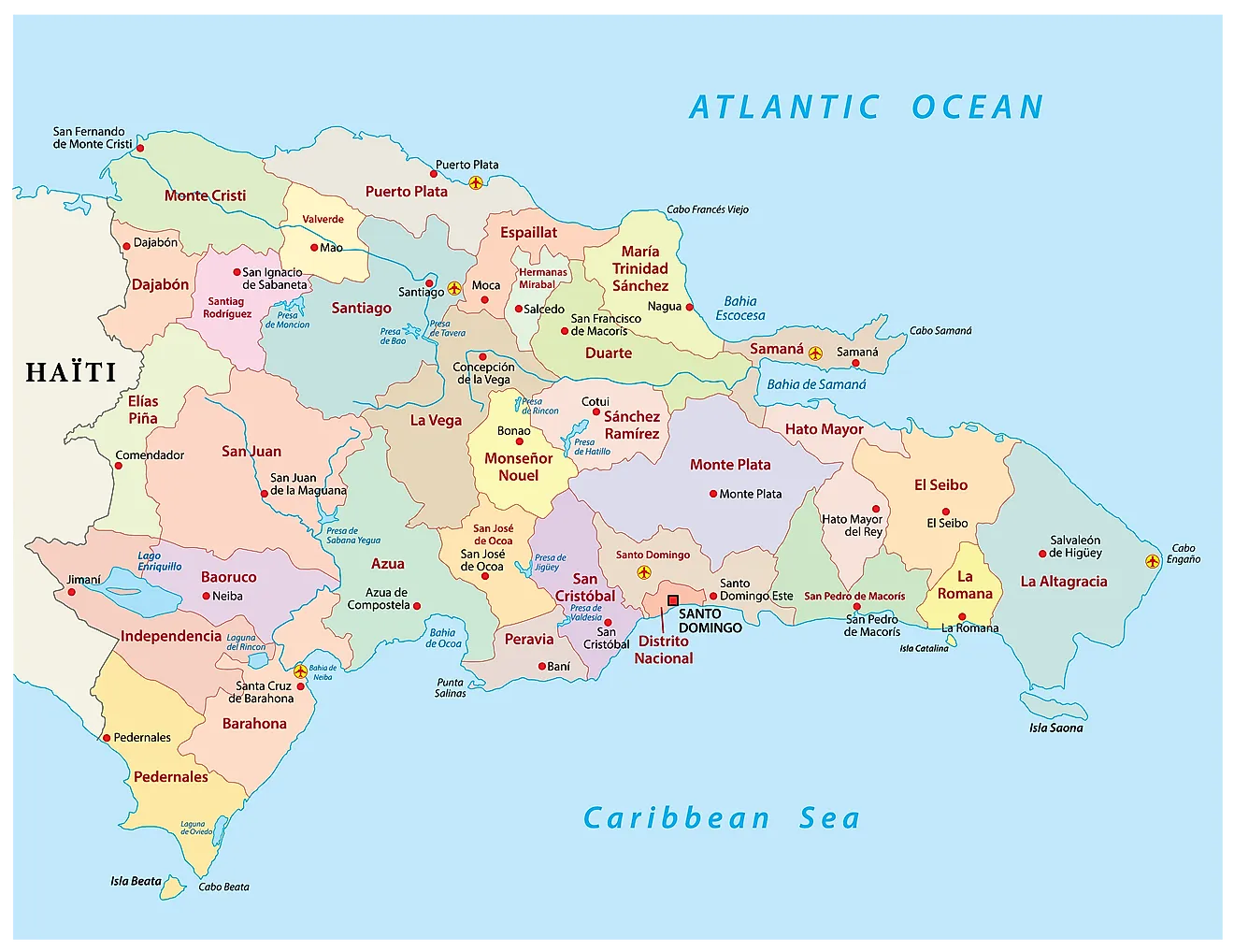
The Dominican Republic is divided into 31 provinces and the National District (Distrito Nacional). In alphabetical order, the provinces are: Azua, Baoruco, Barahona, Dajabon, Duarte, Elias Pina, El Seibo, Espaillat, Hato Mayor, Hermanas Mirabal, Independencia, La Altagracia, La Romana, La Vega, Maria Trinidad Sanchez, Monsenor Nouel, Monte Cristi, Monte Plata, Pedernales, Peravia, Puerto Plata, Samana, Sanchez Ramirez, San Cristobal, San Jose de Ocoa, San Juan, San Pedro de Macoris, Santiago, Santiago Rodriguez, Santo Domingo and Valverde. The provinces are further subdivided into municipalities and municipal districts.
Covering an area of 48,671 sq.km, the Dominican Republic is the 2nd largest island country of the Greater Antilles island chain in the Caribbean Sea. Located on the southeastern coast of the Hispaniola islands, on the banks of the Ozama River is, Santo Domingo - the capital and the largest city of the Dominican Republic. It is the administrative, cultural, commercial, industrial and financial center of the country. Santo Domingo also serves as the country's chief seaport.
Where is Dominican Republic?

The Dominican Republic is a large country located in the north-central Caribbean; occupying the eastern two-thirds of the Island of Hispaniola in the Greater Antilles archipelago. It is positioned in the Northern and Western hemispheres of the Earth. It is bordered by Haiti to the west; the Mona Passage (separating the Dominican Republic from Puerto Rico) to the east; the Atlantic Ocean to the north and by the Caribbean Sea to the south.
Dominican Republic Bordering Countries: Haiti.
Regional Maps: Map of North America
Outline Map of Dominican Republic

The above blank map represents The Dominican Republic, the 2nd largest country in the Caribbean. The above map can be downloaded, printed and used for educational purposes like map-pointing activities.

The above outline map represents The Dominican Republic, the 2nd largest country in the Caribbean.
Key Facts
| Legal Name | Dominican Republic |
|---|---|
| Flag |
|
| Capital City | Santo Domingo |
| 18 28 N, 69 54 W | |
| Total Area | 48,670.00 km2 |
| Land Area | 48,320.00 km2 |
| Water Area | 350.00 km2 |
| Population | 10,738,958 |
| Major Cities |
|
| Currency | Dominican pesos (DOP) |
| GDP | $88.94 Billion |
| GDP Per Capita | $8,282.12 |
This page was last updated on February 25, 2021