7 Scenic Road Trip Stops Along The Trail Ridge Road
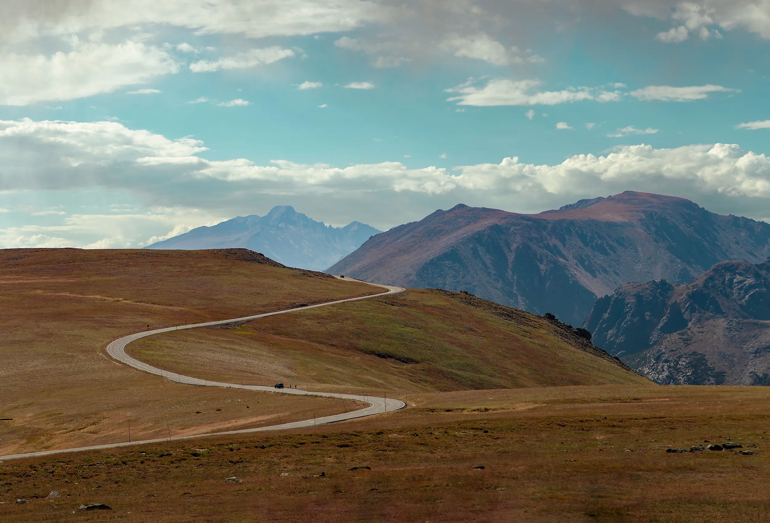
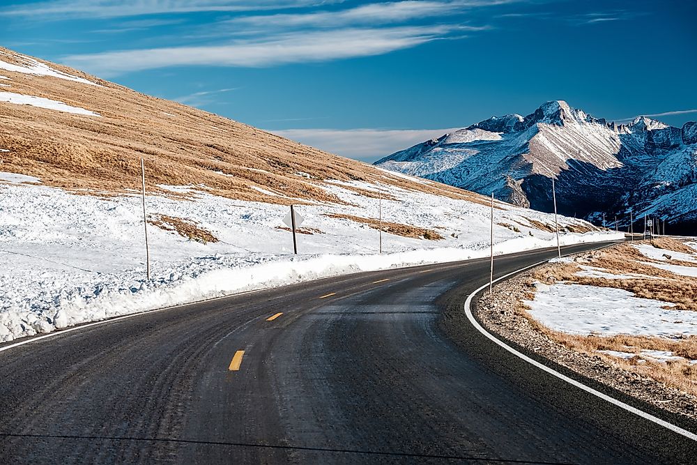
Colorado’s Trail Ridge Road is where human ingenuity and the awesome powers of nature meet. Known as a ‘scenic wonder road of the world’ when it first opened in 1932, this is the highest continuous highway in America, climbing to 12,183ft as it cuts through the Rocky Mountains from Estes Park to Grand Lake. The road took six years to build amid rugged mountainous terrain and harsh weather conditions. That incredible achievement is now one of America’s most popular scenic byways and has earned the road a place on the National Register of Historic Places.
If you’re one of the many visitors excited to drive the Trail Ridge Road this year, check out our guide to its must-see stops. While every section of the drive promises jaw-dropping scenery, think snow-covered peaks, alpine forests, and glacier-carved gorges, some special places merit a longer stop where you can stretch your legs, soak up the spectacular surroundings, and learn more about this magical highway to the sky.
Know Before You Go
Trail Ridge Road is a 48-mile drive. You can complete the route in two hours, but it’s best to give yourself at least half a day to enjoy the stops and scenery. As the byway travels through Rocky Mountain National Park, you will need a permit, and timed entry permits are required from May to October during the park’s busiest season.
The road’s high elevation means it’s generally colder than average Colorado temperatures, so dress warmly and be mindful that the high altitude can cause altitude sickness, common symptoms of which are headaches, nausea, and fatigue.
Trail Ridge Road is closed from mid-October to Memorial, but extreme weather can close the road at any time, so be sure to check before you go. The busiest periods are summer days and weekends, between 9 am and 3 pm, so plan accordingly to avoid the crowds.
Most visitors opt to drive the road from east to west, starting at Estes Park, as this provides a more dramatic ascent into the high-elevation alpine tundra. With that in mind, our stops below run in order from east to west.
Many Parks Curve

The Many Parks Curve is one of the first major overlooks, providing a taste of the breathtaking scenery that awaits you later in the drive. There’s a wide boardwalk here for visitors to stretch their legs while they enjoy the view. And what a view. Looking east, you’ll see Bighorn Mountain, Horseshoe Park, and Estes Park in the distance. Turning northeast, you can look out over the Alluvial Fan, a cascade of water flowing through the boulder field at the base of the Mummy Range. Signs along the boardwalk help sightseers identify what they are looking at, and explain the area’s ancient geology. The overlook is easily accessible and open to all vehicle types, provided the weather is good.
Forest Canyon Overlook

You’ll feel like you’re standing at the top of the world at Forest Canyon Overlook, a viewing point with panoramic views at 11,716ft. Look down and you’ll see a glacier-carved U-shaped valley below, where the ice scoured a crevasse into the landscape, creating Forest Canyon and its tributaries, Hayden Gorge, and Gorge Lakes. On a clear day, you can see Longs Peak (the highest peak in the park at 14,359ft), Stones Peak, and the Terra Tomah Mountain rising into the distant horizon. There’s a short walk from the road to the lookout, and visitors are asked to stick to the path to avoid trampling the delicate alpine tundra flora.
Gore Range Overlook

The Gore Range Overlook is the best way to see one of the jewels of Rocky Mountain National Park, the Never Summer Mountains. The park’s highest peaks, this skyscraping range was created by volcanic activity millions of years ago and takes its name from an Arapaho Indian word that translates to ‘never no summer’. The Gore Range itself is named for the Irish explorer St. George Gore and boasts some of the most rugged terrain in the Rocky Mountains. There’s an easy, 0.1-mile path from the parking lot to the lookout, which allows you to see the peaks from a few different angles.
Alpine Visitor Center

The highest Visitor Center in the parks system, the Alpine Visitor Center is perched 11,796ft high at the intersection of Trail Ridge Road and Old Fall River Road. In winter, the Center is completely buried in snow, but during the summer months, it’s an ideal place to take a break from the drive, stretch your legs, and fuel up. The Center has a ranger’s station where you can ask about any current alerts, a gift shop where you can pick up souvenirs or snacks, and an interactive display about the tundra’s ecology and habitats. If you’re feeling energetic, take the Alpine Ridge Trail, a 0.6-mile walk that starts in the parking lot and is lined with interpretive signs so you can identify the alpine wildflowers that surround the path. The trail opens mid- to late-June.
Milner Pass

The Milner Pass isn’t just a scenic overlook; it’s a site of significant geologic importance. The pass is located on the Continental Divide, which runs from Alaska to Chile and separates the Pacific Ocean drainage from the Atlantic Ocean, meaning that when water falls here, it’s at a tipping point between going east to the Atlantic or west to the Pacific. Read the brown interpretative sign at the overlook’s parking lot to learn more, and then enjoy the views from the mountain pass over the crystal clear waters of Poudre Lake. The pass is also the access point for the Ute Trail which leads back to the Alpine Visitor Center.
Farview Curve

Sitting high above Kawuneeche Valley, Farview Curve is a bend on the Trail Ridge Road with a must-see lookout point. From here, you can see across to the Never Summer Mountains and below to the country’s fifth-longest river, the Colorado River. This is a popular stopping point in the fall as the autumnal foliage sets the Kawuneeche Valley ablaze with fiery aspens. This area has been inhabited for thousands of years, as Native American communities set up seasonal settlements in the valley. In the 1800s, homesteaders tried their luck at making a living in the mountains, and prospectors flooded the valley mining for precious metals.
Holzwarth Historic Site

Life wasn’t easy in the Kawuneeche Valley in the early 1900s. Homesteaders like John and Sophia Holzwarth had to battle severe weather, inhospitable terrain, and dangerous wildlife in their quest to make a home in the Colorado backcountry. Learn their story at the Holzwarth Historic Site, which preserves their property, allowing visitors to get a glimpse into the pioneer era. The cabins are open to the public from Memorial Day to Labor Day, while the grounds are open year-round. Look for the parking lot on Trail Ridge Road, then take the 0.5-mile path to the site itself.
A Road Trip to Remember
Driving through Colorado’s highest peaks on the Trail Ridge Road feels like journeying into another world above the clouds. The road climbs 4,000ft in minutes and travels above the treeline for eleven miles, taking passengers through forest, tundra, and alpine meadow in a dizzying trip skywards. While you’re marvelling at the scenery, keep an eye out for wildlife. Only the most resilient animals thrive at these high altitudes; expect to see pikas, marmots, ptarmigans, and bighorn sheep. Look up and you might even see some bald eagles soaring overhead. The Trail Ridge Road is a road trip to remember, giving visitors the chance to see some of the most incredible scenery in North America from the comfort of their car.