Winooski River
The Winooski River is a 145km long river that flows in the north-central portion of the US State of Vermont. It springs near Cabot in Washington County and runs southwest, then northwest through the Green Mountains, via Montpelier and Waterbury, to discharge into Lake Champlain near the city of Winooski. The river's name has been derived from an Indian term that means "wild onion land." The East Barre Dam is one of the river's flood-control and hydroelectric-power structures.
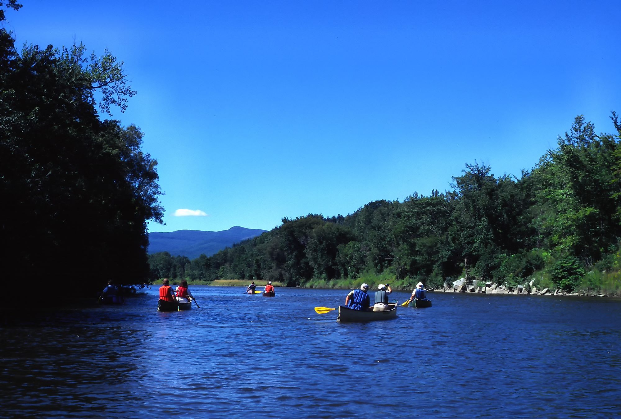
The Course Of The Winooski River

The Winooski River is one of Vermont's largest watersheds. With a length of 145km, the Winooski provides water for various fish. The Winooski River flows southwest from Cabot to Montpellier. The river begins to take shape at this point. Steven's Branch, North Branch, and Dog River all enter the Winooski, roughly tripling its size. The river is fairly sluggish and silty from Montpellier to Middlesex, with few pockets of fish. Excellent wade fishing chances are available from the Middlesex Dam, just upstream of the Mad River confluence, downstream to the Route 2 Bridge in Waterbury. This area of water contains pockets of water as well as deeper flows, riffles, and pools.

The Route 2 bridge marks the higher portion of the river stretch. This two-mile stretch of water near Waterbury will give fishers the best chance of catching a monster fish. This area is easiest accessed via River Road, which runs along the river's south bank. The stretch's bottom boundary is the Winooski Street Bridge. The Little River is the outflow of the Waterbury Reservoir just downstream of Waterbury. During the summer, this tailwater offers icy water and has been recognized as cooling the Winooski River as far downstream as the Huntington River junction. The Little River may be a problematic fishery at times, yet it retains some monster trout. The Bolton Dam is located a few kilometers downstream of the Little River. There are more pools and slower running water from the Bolton Dam downstream, with a few stretches of great pocket water. When the river reaches the confluence of the Huntington, it slows dramatically and becomes more suitable for Smallmouth Bass and Fallfish. River Road continues downstream from the Winooski Street Bridge until it reaches the Janesville Bridge, which is 100 yards upstream of the Huntington River. At this point, the Winooski turns northwest and joins Lake Champlain in the city of Winooski.
Brief History Of Winooski River
Early Native Americans hunted fish, birds, and animals and foraged for different kinds of plants for medical and health purposes. Wood, clay, bone, and plant fibers were used to make tools and containers. The area was arctic tundra ten thousand years ago, and before that, Paleolithic humans hunted animals here. Around 1000 AD, humans began horticulture, with many using the Winooski floodplains or what is now known as Lake Champlain. Samuel de Champlain led a company of Frenchmen into the region in about 1609. They hacked down trees and hauled them away for timber, but they didn't dwell there until approximately 1759. When the English captured the region in 1763, residents from New York and New Hampshire settled there. These settlers attempted to claim Vermont's new holdings as their own, causing the Vermont lands to sell for exceedingly low prices. Ira and Ethan Allen, brothers, purchased significant tracts of property around Winooski and Lake Champlain. And founded settlements that grew into Burlington and several other cities along the Winooski and Lake Champlain. The lake provided transportation and powered mills for different reasons like wool, flour, paper, and (eventually) electricity throughout this period. However, most of those mills would eventually produce electricity solely. There were several farms in the surrounding region. Even though there are fewer farms now, there is greater runoff into the Winooski watershed from more developed areas, despite the presence of more re-grown trees.
Plants And Animal Life

Riverbank trees and bushes safeguard the Winooski River's soil from erosion. One especially significant species is speckled alder, a dense shrub that grows on the banks. Wildlife can also find refuge in bank vegetation. Bullrush, sedges, wild rice, and burreed can all be found in slow-moving water, as can river grape. The Winooski River is a haven for numerous animal species. Sandpipers exploring lake and stream borders for food or swallows capturing insects can be seen in the spring, summer, and fall. Great blue herons, ring-billed and herring gulls, and goldfinches are also common along the river. One must keep an eye out for nesting American ospreys in the snags of huge old trees. Over 50 bird species nest on Vermont's Intervale floodplain, which runs between Burlington and Colchester. The mink, as well as ducks and muskrats, call Half Moon Cove home. Deer are more likely to be seen if nearby regions are wooded. Moose have also been spotted in the Winooski River Basin along the North Branch and other tributaries. Frogs, snakes, turtles, and toads are likely to be seen as you canoe along the river. Muskrats, beavers, water shrews, and otters, all of whom rely on the river for food, are also commonly spotted. Keep a look out for raccoons, foxes, skunks, fishers, and coyotes, who may drink from the river. Wild brook trout, Vermont's sole native stream trout, live in the cold, shady mountain streams. Naturalized populations of wild rainbow and brown trout can be found in large tributaries and throughout the Winooski River. The Winooski River receives a seasonal influx of fish from Lake Champlain. Smallmouth bass and walleye may be found in large numbers downstream of the Bolton Falls Dam. Near the mouth, largemouth bass and northern pike are prevalent. Spawning salmon are captured in the fall and trucked to spawning locations before being released.
Significant Developments

The Winooski River and its tributaries have long been used to generate hydroelectricity. As a supplemental source of revenue, many mills produced power. Standard Light and Electricity Company began producing hydroelectric power for local consumption in Montpelier in 1886. Burlington Light and Manufacturing Company was also offering local hydroelectric electricity about the same period. Later hydroelectric efforts included the construction of Bolton Falls in 1899 and Station #19 at Essex Junction in 1917. Many of the power firms were bought by what is now Green Mountain Power in the 1920s. The Winooski River and its tributaries are the state's second-largest hydroelectric source, with 15 hydroelectric plants in operation, eleven of which are currently operational. In addition to the hydroelectric dams, the Winooski Watershed contains additional 75 dams. The majority of these are on tributaries. Only three of the watershed's dams were constructed for flood control, and they are all on streams. The remaining dams were constructed for recreation, water storage, and modest mill usage.
Threats
Toxic chemicals from the Vermont Air National Guard installation in South Burlington have poisoned not just neighboring wells but also the Winooski River and its tributaries. According to state officials, this is the main lesson from a recent analysis on how far the contamination has extended beyond the base. Marguerite Adelman and her husband Bob Ackland with Military Poisons Vermont discovered 148.5 parts per trillion (ppt) of PFAS (poly-fluoroalkyl substances) in the waters of the Winooski River's Salmon Hole, a popular fishing site in Winooski. The polluted river water comprised 40.5 ppt of the five PFAS compounds regulated in Vermont, with PFOS accounting for 37.8 ppt. These compounds are utilized at the Vermont Air National Guard installation in firefighting foams and other uses. This indicates a significant hazard to the river and public health as these contaminants are bioaccumulating due to affected fish and groundwater.


