6 Best Natural Wonders To Visit In New Mexico This Year
New Mexico packs an unusual concentration of natural extremes into a single state: the world's largest gypsum dune field, one of North America's largest cave chambers, a 14-mile-wide volcanic caldera, and high-desert wetlands fed by the Rio Grande. Some of these places see hundreds of thousands of visitors a year. Others, like the Bisti Badlands, get such light traffic you can hike for hours without seeing another person. Six destinations stand out for the geology alone, and all six are public lands you can drive to without a permit.
White Sands National Park

White Sands National Park, in the Tularosa Basin southwest of Alamogordo, protects 145,762 acres of the world's largest gypsum dune field. The white isn't sand in the usual sense. Gypsum is a soft mineral that, unlike quartz, doesn't absorb heat, which is why the dunes stay cool enough to walk barefoot even in midsummer. Sledding down the dunes is the signature activity, with disc sleds available for purchase or rental at the visitor center. Hiking trails range from the boardwalk-flat Interdune Walk to the five-mile Alkali Flat Loop, which runs across the bed of an ancient lake.

The park draws more than 600,000 visitors a year, with spring and fall offering the best temperatures. Ranger programs are seasonal: full moon hikes run on select dates from March through December, and the three-hour Lake Lucero tour caravans visitors out to the gypsum source basin a few times each season. Both fill quickly, so reserve well ahead.
Carlsbad Caverns National Park

In the Guadalupe Mountains of southeastern New Mexico, Carlsbad Caverns National Park protects more than 119 known caves carved into 250-million-year-old reef limestone. The Big Room, the chamber most visitors come for, is the largest single cave chamber in North America: nearly 4,000 feet long, 625 feet wide, and 255 feet high at its tallest point, with a paved 1.25-mile loop trail running its perimeter. The Natural Entrance Trail, the steep alternative to the elevator, descends 750 feet underground past formations including Iceberg Rock and the Whale's Mouth.

Above ground, the park covers 73 square miles of Chihuahuan Desert wilderness. From late May through October, hundreds of thousands of Brazilian free-tailed bats stream out of the natural entrance at sunset on their nightly hunt, and the park hosts a bat flight talk at the amphitheater every evening during the season. Star party programs run on select nights as well. Timed-entry reservations are required for cave access; book in advance through Recreation.gov.
Valles Caldera National Preserve

Valles Caldera National Preserve sits inside a 13.7-mile-wide volcanic crater that formed 1.25 million years ago when the Toledo and Valles eruptions emptied a magma chamber the size of metropolitan Los Angeles. The collapse left a circular basin in the Jemez Mountains now covered in mountain meadows, winding streams, and second-growth forest. The preserve holds one of the largest elk herds in New Mexico, along with golden and bald eagles, coyotes, prairie dogs, black bears, and badgers. Late May through mid-October offers the best hiking weather and peak wildlife viewing.

The trail network ranges from short interpretive loops to multi-day backcountry routes. The Cabin District Interpretive Trail walks visitors through the historic ranch headquarters of the Baca Land and Cattle Company. The Jemez River Trail follows the East Fork through a canyon with high cliffs on either side, and the Sulphur Creek Trail leads to active geothermal vents at Sulphur Springs, where the ground steams year-round. The preserve also permits horseback riding, fishing, and seasonal hunting under managed permits.
Bosque del Apache National Wildlife Refuge

Bosque del Apache National Wildlife Refuge, south of Socorro along the Rio Grande, protects floodplain wetlands that are a critical winter stopover for migrating waterfowl. From November through February, tens of thousands of sandhill cranes, snow geese, and ducks descend on the managed wetlands, with the dawn liftoff and dusk return drawing photographers from across the country. The refuge also provides year-round habitat for several listed species including the Southwestern willow flycatcher, the New Mexico meadow jumping mouse, the Rio Grande silvery minnow, and the yellow-billed cuckoo.

The 12-mile auto tour loop is the standard way to see the refuge, with multiple pullouts and observation decks along the way. The Observation Blind Trail puts you at eye level with shorebirds at a managed pond, and the Canyon National Recreation Trail climbs into the Indian Well Wilderness Unit for a different perspective on the bosque. The Festival of the Cranes every November draws birders for guided tours, photography workshops, and ranger programs across several days.
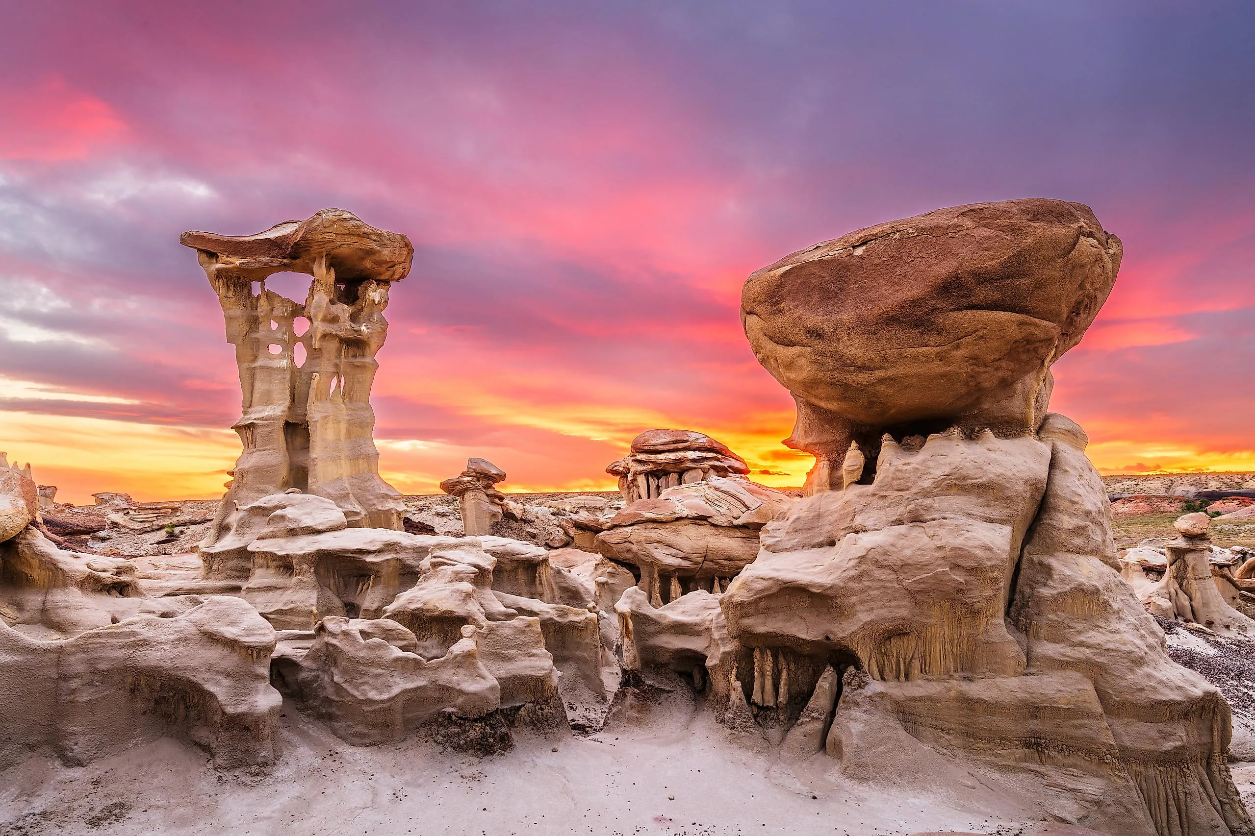
Bisti Badlands/De-Na-Zin Wilderness

South of Farmington in northwestern New Mexico, the Bisti/De-Na-Zin Wilderness covers 45,000 acres of eroded Late Cretaceous formations: hoodoos, fossil-bearing badlands, and shale hills colored by ancient coal seams. The Navajo names translate roughly as "large area of shale hills" (Bisti) and "standing cranes" (De-Na-Zin). The dinosaur Bistahieversor sealeyi was discovered here in 1998. Notable formations across the wilderness include Hoodoo City, the Stone Wings, the King of Wings, and the Alien Egg Hatchery, all reached by unmarked routes across sandstone outcrops and clay hills.

This is genuine trail-less wilderness. Bring a GPS or downloaded map, plenty of water, and orienting landmarks (the Chuska Mountains to the west, the main drainage at the Bisti trailhead). Two access points serve the area: the Bisti Trailhead off NM-371 and the De-Na-Zin Trailhead off County Road 7500. Spring and fall offer the most workable temperatures, and Navajo Tours USA runs guided trips for visitors who'd rather not navigate alone.
El Malpais National Monument

El Malpais National Monument, south of Grants, preserves a volcanic landscape that includes some of the youngest lava flows in the lower 48. Eruptions from multiple cinder cones and lava tubes shaped the monument over the last several hundred thousand years, with the McCartys flow dated to roughly 3,000 years ago. The result is a textbook of volcanic features: ʻaʻā flows, pāhoehoe surfaces, lava-rise plateaus, inflation pits, and an extensive lava-tube system. Spring and fall are the most comfortable times to visit, though winter rewards prepared hikers with ice formations.

The one-mile Lava Falls Trail loops across the youngest flows, marked by rock cairns. The Zuni-Acoma Trail, an ancient Indigenous trade route, runs 7.5 miles one way across rough lava terrain. The Big Tubes area gives access to the lava-tube cave system, where two caves are open to the public with a free permit: the Lava Bomb Cave, a small chamber with a skylight overhead, and the Giant Ice Cave, a wider cave where translucent ice columns persist into early summer. Headlamps and sturdy boots are required for the caves.
New Mexico's Natural Wonders
From gypsum dunes to volcanic crater rims to underground bat colonies, New Mexico's natural wonders cover a remarkable range of geology and ecology in one state. Each destination above offers a distinctive way into the state's landscape: hiking trail-less badlands, watching cranes lift off at dawn, descending 750 feet into a single cave chamber, or driving across a 14-mile caldera. Spring and fall are the best windows for most of these places. Plan for water, layers, and time.