10 Great Road Trips to Take in Colorado
Fans of road trips are in for a treat: Colorado is unmatched for outdoor drama and showiness. In between genuinely extraordinary vistas, tempting stops invite you to pull over and take in the magical splendor. You will wind past some of the highest paved mountain passes in the United States in towns like Aspen, overlook clean, glittering bodies of water in Hanging Lake, spot unexpected historic sites, and rest in outdoor playgrounds with terrific views.
The truth is, these endless miles of well-maintained scenic and historic byways provide easy access to some of the grandest natural attractions on the continent. Continue reading to discover 10 great road trips in Colorado.
Twin Lakes To Aspen (via Independence Pass)

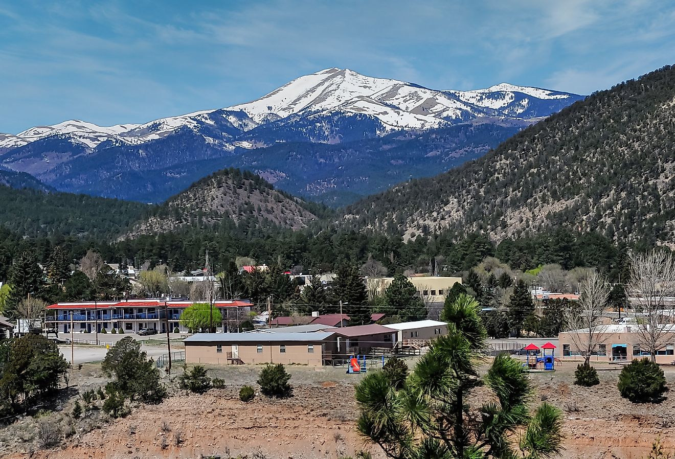
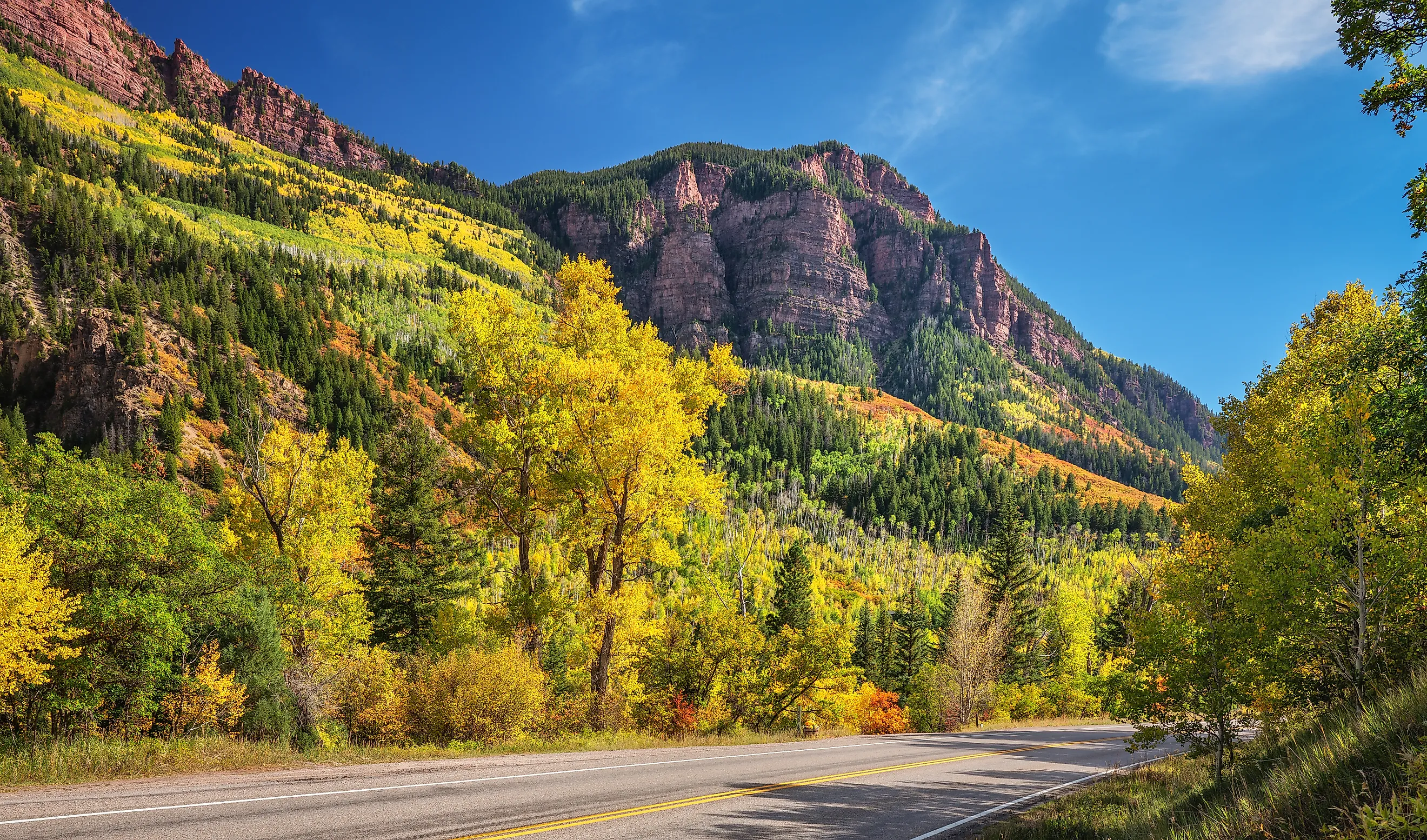
The Twin Lakes to Aspen drive follows Colorado State Highway 82 over Independence Pass, a segment of the Top of the Rockies Scenic & Historic Byway. Twin Lakes is a historic town with a pair of large glacial lakes set against dramatic mountain backdrops. On the other hand, Aspen is a swanky mountain town serving as a glitzy playground for celebrities, billionaires, and high-end shoppers. The drive is short and takes about an hour, though first-timers should allow more time, because they will need to pull over frequently to enjoy the high-alpine, dramatic scenery.

The drive starts in the Highway 82 side of Twin Lakes, winds to the ghost town of Independence amid gasp-inducing curves and switchbacks, before terminating at Aspen. The summit is 12,095 feet, making it one of the highest paved mountain passes in the United States. Independence is an abandoned mining town that offers a quiet, eerie glimpse into Colorado's gold rush era. Other highlights include Lost Man Campground, which offers a peaceful, scenic escape that feels miles away from the everyday hustle and bustle, and Grottos Trail, known for its stunning ice caves and spectacular cascades. Note that the pass is closed in the winter, especially from October to May.
Trail Ridge Road

Another adrenaline-heavy drive with heart-stopping views is Trail Ridge Road, where Highway 34 cuts through the Rocky Mountains, starting at Grand Lake on the west side and ending at Estes Park on the east. To wrap your head around the kind of scenery to expect, know that this road is the highest continuous paved highway in the United States, with its highest point at 12,183 feet. Otherside Gear & Coffee Shop, which boasts a rare 5-star rating on Google Reviews, isn't just any used-gear shop; it's also home to the best coffee in Grand Lake. Farther along, you will find extremely helpful staff at the Kawuneeche Visitor Center, as well as a cute gift shop with interesting items.

At the Green Mountain Trailhead, you can pack your car and mingle with moose, or stop by the Bowen-Baker Trailhead instead, a heavenly place with epic scenery, before settling down at Lake Irene Picnic Area, which features a beautiful lake with a short trail around it. At 10,759 feet, Milner Pass has exceptional views of Poudre Lake and is located on the Continental Divide. Trail Ridge Road is 48 miles one-way.
Denver to Glenwood Canyon via I-70

This portion of I-70 covers about 155 miles and offers enough stunning views, hiking opportunities, rafting, and enough stunning natural views to leave any driver in a trance-like state. It is not often that you find an engineering marvel running directly through dramatic, unspoiled mountain landscapes, which is what makes I-70 a rare gem.

Leaving Denver, I-70 quickly climbs into the Front Range of the Rocky Mountains, passing through evergreen forests and narrow canyons before reaching the historic mining towns of the Clear Creek Valley, including Idaho Springs and Georgetown. From Georgetown, peel your eyes for the 10-foot-tall Griffin Monument, and learn about the heart-rending story that occasioned its construction. At Loveland Ski Area, which boasts 1,800 acres of skiable terrain, take in gasp-inducing views, and find respite at Hanging Lake, an emerald-green attraction, nestled against the backdrop of towering cliffs and lush greenery.
I-70. From Dotsero to Glenwood Springs

The Denver to Glenwood Canyon stretch of I-70 is formidable. This section focuses on the short, 16-mile stretch between Dotsero to Glenwood Springs that captures some of the best high-alpine engineering and canyon scenery in the American West. Here, the I-70 threads along the Colorado River beneath soaring limestone cliffs, through tunnels and viaducts, with constant, dramatic views carved deep into Glenwood Canyon. Several rest areas dot this stretch, including No Name, a rock-climbing haven just three miles east of Glenwood Springs; Grizzly Creek, which offers the perfect float amid gorgeous scenery and wildlife-viewing opportunities; and Bair Ranch, one of the first large sheep ranches in Colorado. Keep in mind that the canyon has a dedicated recreation path for walking, biking, and jogging that runs alongside the highway, meaning trippers have the chance to explore the canyon up close.
Estes Park-Nederland (via the Peak to Peak Highway)

The Peak to Peak Highway is a 42-mile National Forest Scenic Byway and Colorado Scenic & Historic Byway that links Estes Park, which serves as the main entrance to one of the most visited national parks in the U.S., to the Nederland area and beyond, through the heart of the Front Range of the Rocky Mountains. It winds past towering mountains like the 14,255-foot Longs Peak, beautiful alpine valleys with peaceful greenery, and a few one-horse towns.

Take the trip in fall for a spectacular color show, with cinematic burst of golds, yellows, and oranges. Start with a short stretch along the Riverwalk in downtown Estes Park, a beautiful, one-mile paved scenic pathway alongside the Big Thompson and Fall Rivers through the heart of the town. Afterwards, hit the road, peeling your eyes for Ward, a former boom town and bohemian magnet that was once the richest town in Colorado. South Saint Vrain Trailhead, which features lush, soothing vegetation, is just north, and Peaceful Valley, where you will see a little onion-domed church perched on a hillside, sits inside a serene horseshoe bend. Nederland, which bookends the drive on the other side, is a hippie holdout with quirky shops and colorful cafes.
Durango to Four Corners via US 160

The first section of this trip, roughly from Durango to Cortez, a popular stop regarded as the Archaeological Capital of the United States, is a breathtaking 45-mile journey through mountain valleys, historic towns, and golden autumn landscapes. From Durango’s red-brick downtown, the US 160 rises in elevation, flanked by peaceful cottonwoods and horse pastures. It climbs to Hesperus, a small but scenic outpost with rural views and fresh air. Paralleling the curves of the Mancos River, the drive snakes through high mesas and forested ridges, reaching Mancos, a historic ranching town that still feels like a frontier outpost.

From here, the next big thing is the Mesa Verde National Park, one of the crown jewels of the American Southwest and a UNESCO World Heritage Site, preserving the cliff dwellings of the Ancestral Puebloans. Farther ahead is Denny Lake Park, a serene place that unofficially marks Cortez’s eastern edge. In the other 40-mile section, particularly from Cortez to the Four Corners Monument, the land rolls gently beneath an expansive sky, dotted with desert scrub and framed by distant mesas, especially towards the end. You will cruise through the Ute Mountain Ute Tribal Lands, an aspect that speaks to the deep indigenous history that defines the landscape.
Bent’s Old Fort National Historic Site to Trinidad (via the Santa Fe Trail)

The hazy, misty past comes alive as you traverse one of the last strongholds of the nomadic Plains Indians and one of the first toeholds of Anglo-American pioneers. History nerds know that this region was known for homesteading along the Arkansas River, especially in the 1860s. Even today, those who are keen can notice the wagon-wheel ruts of the Santa Fe Trail, especially on a crisp, clear day. Although the whole Colorado stretch is about 188 miles, the section from Bent’s Old Fort National Historic Site to Trinidad spans about 118 miles. Bent's Old Fort, where this drive begins, was the center of a trading network that featured Plains Indians and fur trappers. It can be a big mistake to miss the Otero Museum in La Junta, which displays amazing historical exhibits and memorabilia, or Lucy's Tacos, a make-shift food trailer with indoor and outdoor seating. Keep tabs on the Sierra Vista Interpretive Site, which offers a wonderful 360-degree view of the Colorado Plains; the Timpas Picnic Area; and the A.R. Mitchell Museum of Western Art in Trinidad, which showcases gorgeous Native textiles.
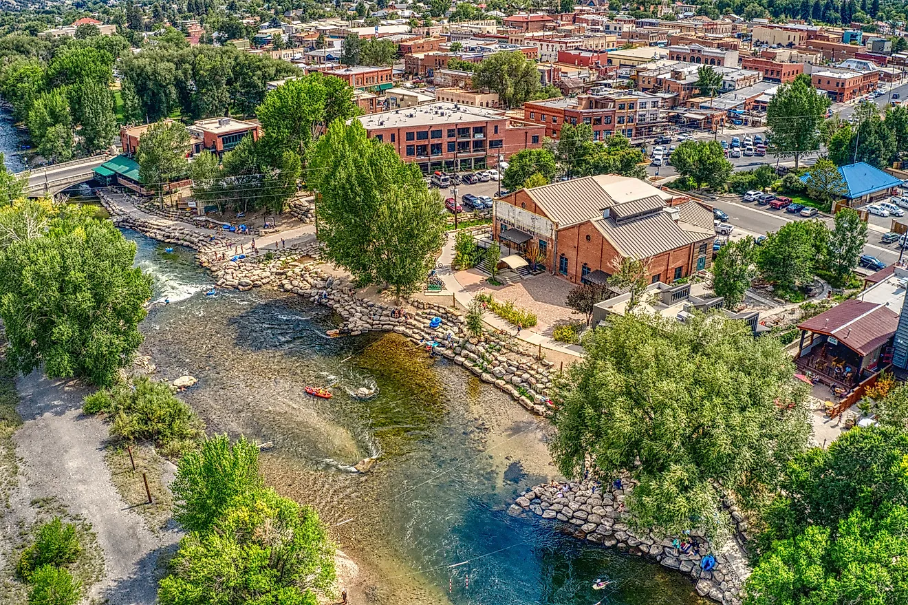
Salida to Pueblo via US Highway 50

From high mountain vistas and beautiful river valleys near Salida, to rock-walled canyons and red-hued cliffs around Canon City, and even the wide plains and open horizons into Pueblo and beyond, the Salida-to-Pueblo drive captures the best of Colorado’s diversity in a single drive. The entire trip is about 97 miles, and it winds through several small, beautiful towns, where you can jump out and have a leisurely bite.

If you are a cappuccino connoisseur, start your adventure at Coffee by Topo, then hit the road for Poncha Springs, where lovely views of the surrounding Sangre de Cristo Mountains will draw your attention. Jump off the highway for a spell to see the Royal Gorge Bridge & Park in Canon City, which features one of the world's highest suspension bridges, soaring 956 feet above the Arkansas River. Crown the day with a stroll along Pueblo’s Riverwalk, followed by a memorable dinner at Olive Garden Italian Restaurant.
Trinidad to Walsenburg

You may have heard that George Simpson saved Trinidad from marauding Utes by distracting them with taunts, or how a band of conquistadors disappeared near the Purgatoire River in the 1590s, never to be seen again. The drive from Trinidad to Walsenburg is so steeped in Native American legends that it is called the Highway of Legends. Although you will not make ground-breaking discoveries publishable by history journals, you will enjoy the dramatic settings that have inspired several of the tall tales among Native American nomads, Spanish explorers, and Hispanic settlers for centuries.

Trinidad, a shining star on the route, features the Trinidad History Museum, which offers a crash course in the area’s local history. You will want to explore the countless rows of coal ovens in Cokedale; Cuchara, which offers heart-gripping views of the Spanish Peaks; and La Veta, where there are more churches than paved roads. Keep in mind that the Cucharas River offers excellent fishing opportunities, while the Spanish Peaks Wilderness is a hiker’s paradise riddled with scenic trails. The whole drive is about 82 miles.
Colorado State Highway 133 from Carbondale over McClure Pass to Paonia

Part of the West Elk Loop Scenic Byway, a 205‑mile scenic loop that showcases Colorado’s mountains, mesas, rivers, and canyon country, the drive from Carbondale to Paonia over McClure Pass is a signature Western Colorado mountain drive through the Elk Mountains and North Fork Valley. From Carbondale, the route starts by following the Crystal River, amid towering cliffs, alpine meadows, and fabulous river views. Grab a large, Detroit-style pizza at Propaganda Pie in Redstone, then jump back on the road to McClure Pass, a scenic mountain pass at 8,755 feet elevation that offers breathtaking views of the Elk Mountains. The stretch is marked by one major switchback at the north end and a 4.5-mile dirt road called Ragged Mountain Road, which is usually open for hiking. Also, the USFS operates the McClure Campground at the pass summit. This drive spans about 58 miles, a perfect day trip.
So, if there’s a state where road trippers will have a nirvana-level experience, it is certainly Colorado. The Centennial State has more than 50 peaks standing higher than 14,000 feet, more than triple the rest of the Lower 48 combined. Think of crazy switchbacks, vertical cliffs, and the solemn grandeur typical of such environments. This means you will need two things: a steady heart and steady hands on the wheel.