Cyclones
In meteorology, a cyclone is described as a large volume of air that rotates around a strong center of low barometric pressure. Distinguished by the inward-spiraling winds that circulate about a low-pressure zone, cyclones move in a counterclockwise direction in the Northern Hemisphere and a clockwise direction in the Southern Hemisphere. Except for the Equatorial belt region, the cyclonic winds closely move across every region on Earth and are usually connected with heavy rainfall. The four main types of cyclones include Tropical cyclones, polar cyclones, mesocyclones, and Extratropical cyclones. Tropical Storms are considered dangerous, as these cyclones generate strong gusty winds, heavy rainfall with flooding, and damaging storm surges that lead to inundation of low-lying coastal regions.
Nomenclature Of Cyclones

The term ‘cyclone’ has been derived from the Greek word “cyclos,” which means “the coils of a snake.” The term was coined in 1848 by the English sea captain Henry Piddington in his book, “The Horn-Book for the Law of Storms for the Indian and China Seas.” It is believed that Henry Piddington named this climatological phenomenon after witnessing the “seaborne storm’s circular movement and eerily hollow center” formed in the Gangetic River Basin. Between 1836 and 1855, more than 40 papers on the tropical cyclones from Calcutta were published by Henry Piddington in The Journal of the Asiatic Society.
Cyclones are known to have different names in different portions of the world. For example, when tropical storms develop over North Atlantic, Eastern North Pacific, and Central North Pacific, they are called “hurricanes.” When the storms form over the Indian Ocean and South Pacific, they are called “cyclones;” over the Northwest Pacific, they are known as “typhoons;” over Guinea lands of West Africa and in Southern US as “tornados;” and “willy-willies” in northwestern Australia.
Structure Of Cyclones
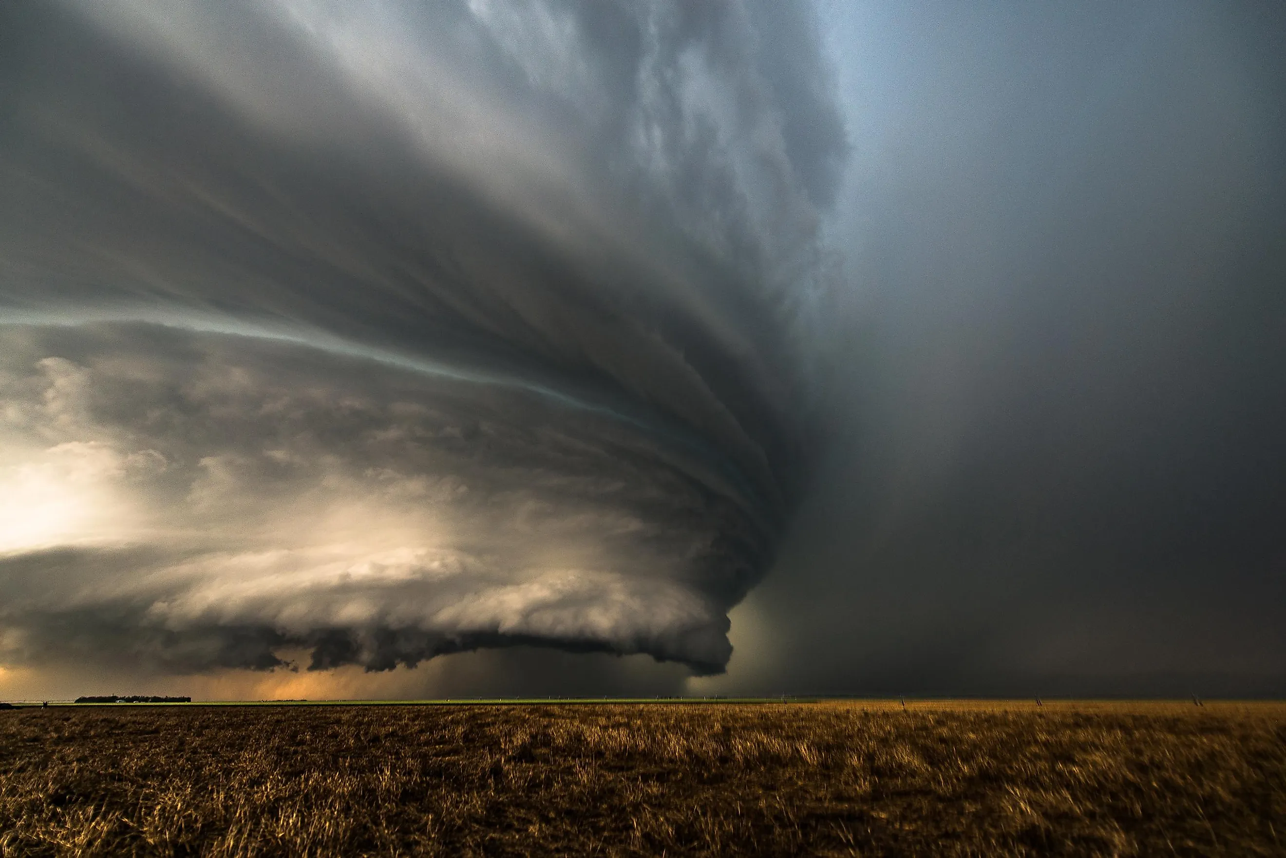
The structural features common to all cyclones include the eye, the eyewall, and the spiral bands. It must be noted that close to the storm’s center, the pressure gradient force and the force from the Coriolis Effect must remain in an appropriate balance; otherwise, the cyclone might collapse due to the pressure difference.
Eye

The ‘Eye’ refers to the roughly circular area at the geometric center of a severe tropical cyclone. It is a region of minimum barometric pressure and the warmest temperatures in the upper levels. Characterized by light winds and sinking air, this relatively calm and clear area is about 19 to 40 miles in diameter and is surrounded on all sides by the towering eyewall.
Eyewall
The roughly circular ring of deep convection surrounding the eye is called the eyewall. This region has the maximum sustained winds in a tropical cyclone and is the portion of a cyclone that causes damage to both lives and property. It is to be noted that the eyewall is actually a ring of thunderstorms, and any changes in the eye or the eyewall will significantly affect the storm’s intensity.
Spiral Bands
The prolonged, narrow rain and thunderstorm bands on the outer parts of a cyclone are referred to as spiral bands. These bands are oriented in the same direction as the movement of the winds. Formed by convection, these bands seem to spiral into the center of a tropical cyclone.
Conditions Required For Formation Of Cyclones

Six main conditions are required to develop and strengthen tropical cyclones in the atmosphere. These conditions include:
- Warm temperatures at the sea surface (79.7°F and above spanning through at least a depth of 60 m)
- Instability in the atmosphere that encourages the formation of substantial vertical cumulus clouds.
- High humidity (about 50 to 60%) in the lower to middle levels of the troposphere
- Presence of Coriolis force sufficient to create a cyclonic vortex
- A pre-existing weak low-pressure area
- Weak Vertical wind shear
The process of development and strengthening of cyclonic circulation in the atmosphere is referred to as cyclogenesis. The ideal combination of a warm core and significant convective activity in a favorable atmospheric environment results in the formation of Tropical Cyclones. It has been recorded that worldwide an average of 86 tropical cyclones are formed yearly, of which 47 reach the strength of hurricanes or typhoons, and the remaining become intense tropical cyclones.
Formation Of Tropical Cyclones

Multiple thunderstorms originate over the oceans under suitable conditions. These thunderstorms then merge and form an intense low-pressure system. Due to its warm and light nature, the air in the thunderstorms is uplifted. After reaching a certain height, the air temperature falls, and the moisture in the air undergoes condensation. This releases heat into the atmosphere, making the air warmer and lighter. This warmed air continues to rise, with fresh moisture-laden air from the ocean taking its place and creating more wind. Due to this excess moisture, the thunderstorm intensifies and takes in more air at a much higher rate. Due to Coriolis Effect, the air which rushes in from the surroundings undergoes deflection and creates a cyclonic vortex.
Due to centripetal acceleration, the air in the cyclonic vortex is forced to form a calm area at the cyclone’s center, called the ‘eye.’ The vortex’s inner surface includes the cyclone’s most violent region – the ‘eyewall.’ In due course, all the air which is carried upwards loses its moisture and becomes colder and denser. This air then descends downwards through the cylindrical eye region at the edges of the cyclone. It is to be noted that the primary driving force behind the formation of cyclones is the continuous moisture supply from the oceans. On reaching the land, when this moisture supply is cut off, the cyclone dissipates.
Categories Of Tropical Cyclones
Tropical Cyclones worldwide are categorized on a scale of 1 to 5 by the Saffir-Simpson Hurricane Wind Scale based on the intensities of their sustained winds. This scale was initially developed in the United States in 1971 by the American civil engineer Herbert Seymour Saffir and American meteorologist Robert Homer Simpson. The Saffir-Simpson Hurricane Wind Scale separates hurricanes (which are tropical cyclones in Western Hemisphere) into five different categories based on their wind speeds and impacts.

Category 1
When a storm’s wind speed is between 74 and 95 mph, it is categorized as a Category 1 storm. Category 1 storms cause no significant structural damage to well-built, permanent structures. However, these storms can uproot weak trees, topple unanchored mobile homes, and cause pier damage and some flooding in coastal areas. Some examples of Category 1 storms include Hurricane Juan, Hurricane Danny, Hurricane Humberto, Hurricane Earl, etc.
Category 2
When a storm’s wind speed is between 96 and 110 mph, it is categorized as a Category 2 storm. Category 2 storms can cause damage to roofing material as well as poorly built doors, windows, signs, and piers. Mobile homes and several manufactured homes can also often suffer significant structural damage. Category 2 storms can also lead to loss of potable water and extensive power outages. Some examples of Category 2 storms include Hurricane Diana, Hurricane Rosa, Hurricane Alma, Hurricane Richard, etc.
Category 3
When a storm’s wind speed is between 111 and 129 mph, it is categorized as a Category 3 storm. Category 3 storms cause extensive structural damage to small buildings and serious coastal flooding. Some examples of Category 3 storms include Hurricane Audrey, Hurricane Olivia, Hurricane Elena, Hurricane Fran, etc.
Category 4

When a storm’s wind speed is between 130 and 156 mph, it is categorized as a Category 4 storm. Category 4 storms cause widespread structural damage, flattening mobile and manufactured homes, uprooting several trees, extensive beach erosion, and flooding flat land and inland areas. Some examples of Category 4 cyclones include Hurricane Betsy, Hurricane Carmen, Hurricane Joan, Hurricane Luis, Hurricane Dennis, Hurricane Ida, Hurricane Ian, etc.
Category 5

The highest category in the Saffir-Simpson scale is the Category 5 storms having wind speeds of more than 156 mph. These storms cause the complete destruction of several residential as well as industrial buildings, the collapse of roofs and walls, the flattening/ washing away of many coastal structures due to storm surges, water loss, long-lived power outages, and the uprooting of all trees. Some examples of category 5 storms include Hurricane Dorian, Hurricane Maria, Hurricane Felix, Hurricane Andrew, etc.

At present, it is possible to detect a cyclone right from its origin in the oceans and track its course, warning the region’s residents at least 48 hours before the cyclone’s landfall. Therefore, in the advent of cyclone landfall, the residents of that area must take necessary precautions and follow the orders of higher authorities if there is a need for an emergency evacuation. A special Intergovernmental Panel on Climate Change report titled “Ocean and Cryosphere In A Changing Climate” has predicted that warmer sea surface temperature across oceans caused by anthropogenic climate change is directly responsible for the rapid intensification of devastating tropical cyclones. Rising sea temperatures are said to impact cyclones' direction, strength, development, and impacts. Therefore, as climate change accelerates, the frequency and intensity of natural disasters will keep increasing.