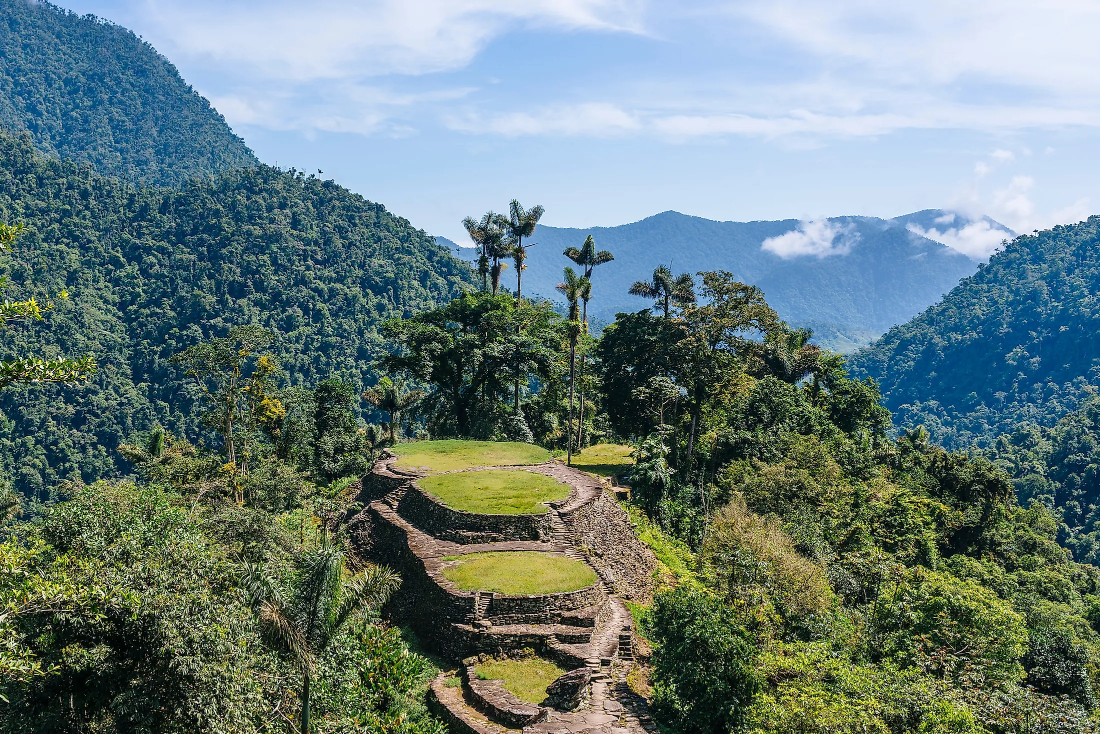
Sierra Nevada de Santa Marta, Colombia
The Sierra Nevada de Santa Marta mountain range is a coastal mountain range located in northern Colombia, covering approximately 17,000 square kilometers. Located on the shores of the Caribbean Sea, it is one of the world’s highest coastal mountain formations, with two peaks exceeding 5,700 meters above sea level. The range’s highest peak is either Pico Simon Bolivar or Pico Cristobal Colon. The mountain range is the source of at least 36 rivers, including Magdalene, Cesar, and Gaira River. Santa Marta Range is home to several ecosystems, constituting unique cultural and historical wealth, and was designated a UNESCO Biosphere Reserve in 1979. It is the site of the lost city of Ciudad Perdida.
Contents:
Geography

The Santa Marta Mountain Range is a volcanic massif in northern Colombia located in La Guajira, Cesar, and Magdalene Departments. It is bounded on the south, east, and west by a coastal lowland and north by the Caribbean Sea, with only 22 kilometers separating the peaks from the sea. The mountain range rises abruptly from the Caribbean coast and runs for about 42 kilometers before reaching the snowcapped peak Cristobal Colon, believed by many to be Colombia’s highest peak. However, Pico Simon Bolivar may also be the range’s highest peak since the authorities are yet to determine the higher of the two peaks. Local data, including topographic maps, indicate the two peaks are about 5,700 meters tall and not 5,775 meters as earlies estimated.

The Santa Marta Mountain Range is the most elevated coastal range in the tropics and one of the highest in the world. However, it covers a smaller area compared to most high coastal peaks, stretching about 17,000 square kilometers. The range is separated from the Andean Mountains located in central Colombia. Besides the mountains, the Sierra Nevada region comprises tropical forests, waterfall, natural pools, cultural and historic sites, and the indigenous people who have lived in the area for centuries. Santa Marta range receives an estimated annual rainfall of 4,000 mm at higher elevations of between 500 and 1,500 meters.
Geology

Until recently, the range's geological composition was relatively unknown. However, according to the available data, the mountain range comprises gneiss, granite, diorite, syenite, and eurite of the Tertiary Age. Due to its isolation and the west-east direction, the massif likely formed before the Andes, which runs from north to south. The Smithsonian research team revealed that Santa Marta Range traveled for about 2,200 kilometers from northern Peru to northern Colombia and rotated to its current position on the Caribbean coast in the last 170 million years. The mountain range exhibits fascinating features, including an indented coastline, steep bay shores, and high plunging cliffs.
Biodiversity

The mountain region comprises tropical rainforest containing perennial trees whose canopies rise to 30-40 meters. The region has over 300 vascular plants, including maripa used by the locals to make alcoholic beverages. Santa Marta Range has several ecoregions, including the montane forest ecoregion. The montane forest is located at an elevation just above sea level to about 800 meters, containing distinct plants such as Andean royal palm. Below the Montane forest ecoregion is the xeric shrublands and dry forest, while above it is the cloud forests and Sub-Andean forest ecoregions. The Santa Marta Paramo ecoregion is located at an elevation of 3,300 to 5,000 meters and contains mainly the paramo vegetation.


