Shoshone Falls
Shoshone Falls, also called the “Niagara of the West”, is a 65-meter waterfall in western United States in south central Idaho. The waterfall originates on Snake River, approximately 5 kilometers northeast of the city of Twin Falls, Idaho. Shoshone Falls was documented by Europeans as early as the 1840s and it started gaining tourist attraction in the early 1860s, despite its isolated location. In addition to its remarkable height, Shoshone Falls has had several economic benefits throughout history. The Falls was an important fishing and trading place for the Native Americans, and it sets the upper limit of fish migration on Snake River.
At the beginning of the 20th century, the Snake River was diverted for the irrigation of Magic Valley, and today the falls have contributed to the early economic development of southern Idaho via hydroelectric power stations built there. Today, Shoshone Falls is overlooked by a park operated by The City of Twin Falls. The waterfall is best viewed in the spring since water levels decrease in the late summer and fall as a result of the Snake River's waters being diverted for irrigation purposes. In general, the flow over the falls can range from more than 570 m3/s during late spring of wet years to a minimum of 8.5 m3/s during a dry year.
Structure Of The Shoshone Falls

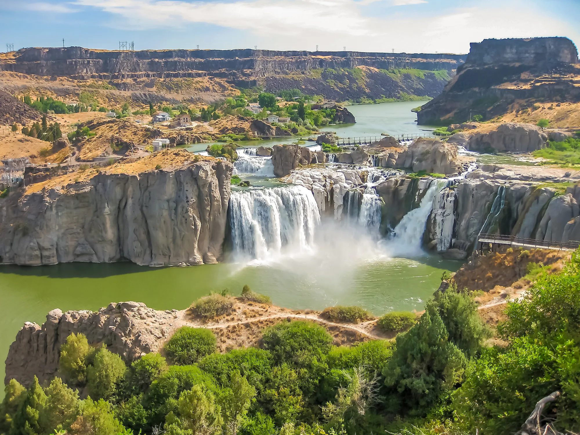
Shoshone Falls is one of the tallest cataracts along the stretch of Snake River, located 3 kilometers downstream from Twin Falls and 2.4 kilometers upstream from Pillar Falls. The waterfall is on the Snake River Canyon in the Magic Valley area which forms part of the boundary between Twin Falls Country to the south and Jerome County to the north. The Falls are 990 kilometers upstream from the Snake River’s confluence with Columbia River.
Before reaching the Falls, Snake River narrows to less than 120-meters wide and rushes over a series of rapids between islands before plunging over a 65-meter horseshoe-shaped cliff with a 282-meter width. However, the appearance of the falls is affected by the flow rate whereby the falls appear as a single block during wet years and high water. On the other hand, the waterfall can split into four or more distinct drops during dry years. The northern section, also being the widest, is called Bridal Veil Falls.
Geology
Shoshone flows over a 6-million-year-old rhyolite that is silicon rich and intersects the weaker basalt layers constituting the surrounding Snake River Plain, a flat bow shaped depression that covers about a quarter of Idaho. This intersection creates a natural knickpoint that is resistant to water erosion. The falls were created about 14,500 to 17,000 years ago at the end of the Pleistocene Ice Age when pluvial Lake Bonneville, a vast freshwater lake that covers the Great Basin, overflowed through Red Rock Pass in southern Bannock County Idaho and into Snake River. This incident was also known as the cataclysmic Bonneville Flood. The massive flow of water, estimated to be 4,600 km3, was the primary factor in the formation of the Snake River Canyon in a matter of weeks in addition to the formation of falls like Shoshone.
Wildlife

Shoshone Falls restricts the upstream movement of fish due to its great height. Anadromous fish such as salmon, rainbow trout and sturgeon can not pass the falls. Before the construction of dams on the lower part of Snake River below the falls, spawning fish would congregate at the base of the falls which became a major food source to for the Native Americans who resided in the area. Examples of fish include the Yellowstone cutthroat that lives above the falls and rainbow trout that resides in the lower part. However, these species are now less likely to be seen due to river diversions and competition from new species such as the lake trout. The Snake River portion above Shoshone Falls shares 35 percent of its fish species with those in the lower Snake River below the falls. mollusk, such as snails and clams, are also endemic in the upper Snake River above the falls.
History
The Shoshone Falls are named after the Lemhi Shoshone tribe who lived in the upper Salmon River in Idaho. This Native American tribe was known as the “Salmon eaters” because salmon originating from the Snake River was their primary food source, aside from various roots, nuts and buffalo. Since the falls were an upstream limit to salmon migration along the Snake River, it served as a primary food source and a trading center for the tribes. The Bannock people who are also affiliated with northern Shoshone traveled to the falls each summer for fishing.
In 1869, gold was discovered in the canyon nearby Shoshone Falls which attracted about 3,000 miners by 1872. The richest deposits were presumably located in Murtaugh, about 25 kilometers above Shoshone Falls, and Clark’s Ferry, 30 kilometers below the falls. However, the gold rush ended due to the nature of the sediment deposits around the falls which made it difficult to extract gold.
Visiting The Shoshone Falls

Despite the isolated surrounding of Shoshone Falls, it became a tourist attraction is the mid-19th century. Initially, travelers along the Oregon trail would stop to visit the falls since it only required a slight detour to the north. Unlike Niagara Falls, Shoshone was known as the “lonely grandeur” of the country since it didn’t have any nearby commercial development. Thomas Moran, famous for his depictions of rugged western landscapes, painted the falls for the 1901 Pan American Exposition. It was early on when the touristic aspect of the falls was realized and that was the work of Charles Walgamott in 1876. Walgamott fenced large tracts of land surrounding the falls and began construction on a lodge hoping to obtain legal ownership of the land. In April 1884, Walgamott was granted a license to operate a cable ferry across Snake River upstream the falls. However, it was one of the most dangerous river crossings in Idaho.
In the early 1900s, locals pushed for the creation of a national park that included Shoshone Falls, even though it was never approved by Congress. In 1932, Frederich and Martha Adams donated the land to the City of Twin Falls with the only condition being that the land is maintained as a public park. The Shoshone Falls Park includes the south bank of the Snake River at the falls. The Park also includes a trail system along the south rim of the Snake River Canyon, and it provides access to nearby points of interest such as Dierkes Lake and Evel Knievel’s 1974 jump site. In 1933, the state of Idaho donated the land to the west of the original park site to the City of Twin Falls, which now owns and operates the Shoshone Falls/Dierkes Lake Complex. This complex offers several recreational facilities such as playgrounds, hiking trails, landscaped picnic areas, a boat ramp and a swimming area. Visitors and picnic-lovers can enjoy their activities in the shaded areas which also offer great vantage points for viewing the falls.