Flume Gorge, New Hampshire
Flume Gorge, situated in the US State of New Hampshire, may seem like an amusement park ride, but it is not the creation of an engineer. Molten rocks, ice, running water, and frost have sculpted this remarkable chasm, which is a centerpiece of the state's Franconia Notch State Park. It is a must-see while visiting the White Mountains.
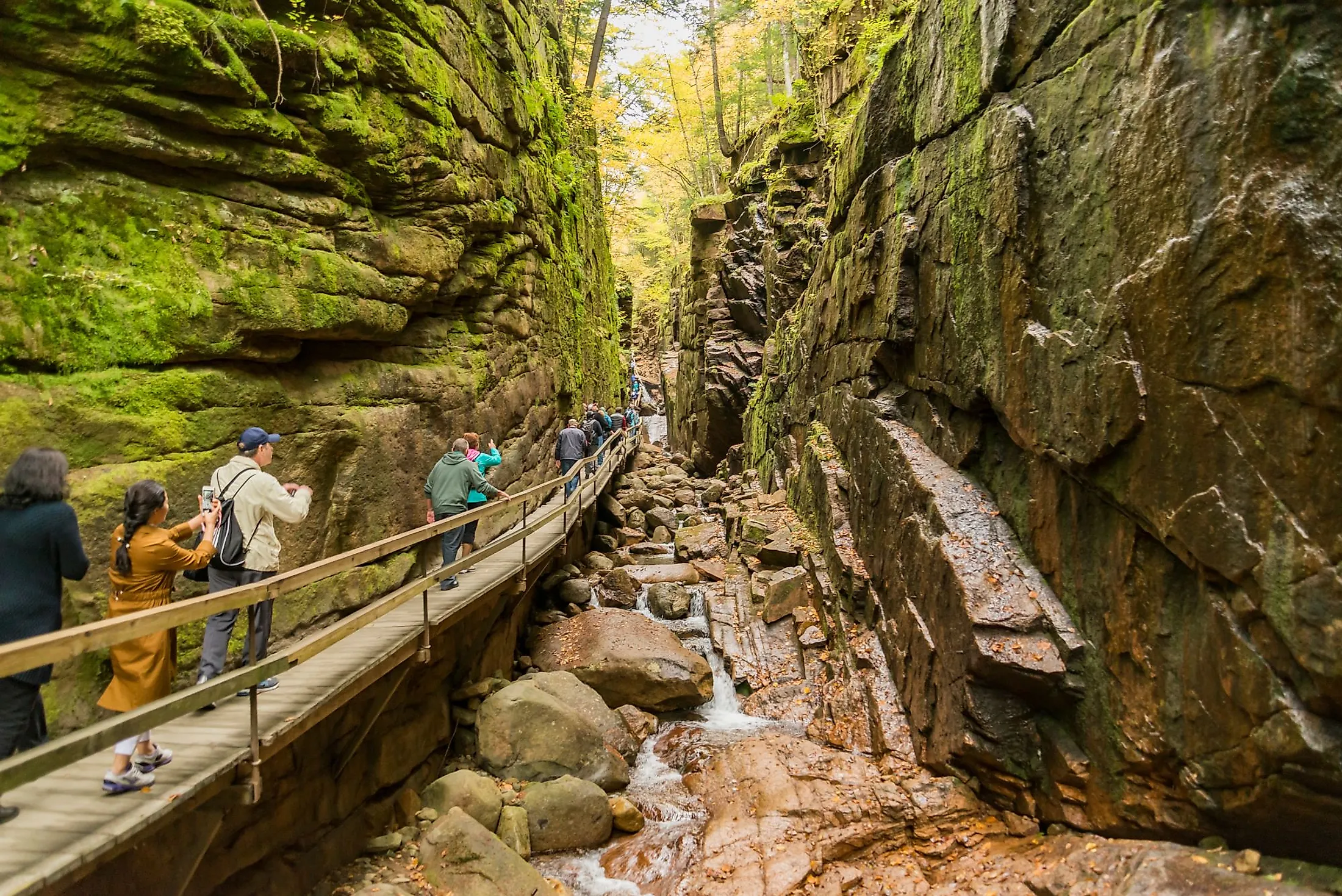
Geography And Climate Of Flume Gorge

The Flume is a 240m long natural gorge situated at the base of Mount Liberty in New Hampshire's Franconia Notch State Park. It is a narrow scenic gorge with moss-covered granite cliffs on both sides. Consider 90-foot-tall walls that are just 12 feet apart at their narrowest point, for a total length of 800 feet at the base of Mount Liberty. Visitors are transported across the gorge by wooden boardwalks, which provide access to the narrowest areas with waterfalls, stones, and pools. Flume Gorge also has two very distinct yet attractive covered bridges, stretches of calm woodland track, and a breathtaking outlook over endless rolling hills. The two-mile Flume Gorge circle trip is simple, enjoyable, and scenic – but expect people and arrive early to avoid foot traffic, particularly in the small gorge area.
According to the Köppen climate classification, Flume Gorge experiences a humid continental climate with warm, wet summers and cold, snowy winters. The average yearly temperature is 6°C, with July and January recording the highest (19°C) and lowest (-8°C) average temperatures, respectively. On average, Flume Gorge gets 546.1mm of precipitation each year, with June reporting the highest number. The average annual relative humidity is around 72%, with a wind speed of 8km/h.
Brief History And Formation Of Flume Gorge
The Flume was found by chance in 1808 by a 93-year-old "Aunt" Jess Guernsey while fishing. She had difficulty persuading her family of the incredible find, but she ultimately encouraged others to come and see it. A massive egg-shaped boulder sat hanging between the walls at the time. The rock stood 3 meters tall and 3.6 meters long. An intense downpour in June 1883 triggered a landslide, which washed the boulder away. The same storm carved out the gorge and created the Avalanche Falls. The Conway granite that formed the Flume's walls was deeply submerged in molten lava over 200 million years ago during the Jurassic Period. As the granite cooled, it was split up by closely spaced vertical fractures that ran almost parallel in a northeasterly direction. Small basalt dikes were driven up along the cracks after the fractures developed. The basalt emerged from deep under the ground as a flowing substance and was able to push the Conway granite aside due to pressure. Against the comparatively chilly granite, the basalt crystallized fast. Basalt is a fine-grained rock as a result of its rapid cooling. If this material had ever reached the surface, it would have turned into lava flows. The earth's surface was progressively reduced by erosion, exposing the dikes. The pressure was alleviated when the top rock was worn away, and horizontal fractures formed, allowing water to enter the rock strata. The basalt dikes eroded quicker than the underlying Conway granite, creating the gorge's current valley. During the Ice Age, glaciers covered the valley, although the ice sheet did not significantly alter the landscape. It stripped soil, weathered rock from the area, and partially filled the valley with glacial debris. Flume Brook began to flow across the valley again after the Ice Age. Frost and the brook's water have both degraded the heavily fragmented granite and basalt. As one goes through the Flume, one looks at the Gorge floor for remnants of the significant basalt dike, and little trees are sprouting on the gorge walls. Erosion is still taking place.
Fauna Of Flume Gorge
This region's fauna includes moose, deer, bear, fish, and snowshoe hare. Year-round residents include dark-eyed juncos, evening grosbeaks, and boreal chickadees. Summer inhabitants include common loons, ospreys, and Blackburnian and bay-breasted warblers.
Attractions In Flume Gorge
The Flume Covered Bridge

This scenic-covered bridge is one of the state's oldest. It was constructed in 1886 and has been repaired multiple times. Because of the darkness and solitude they afforded, such bridges were sometimes referred to as "kissing bridges." This bridge spans the beautiful Pemigewasset River. In the Abenaki language, pemigewasset means "swift or quick stream."
Table Rock

The flowing waters of the Flume Brook revealed this enormous protrusion of granite over time. Table Rock is a 150m long and 20m broad chunk of Conway granite. Visitors are requested to keep on the trail since the rocks are slippery.
Avalanche Falls

Avalanche Falls may be seen from the top of the Flume. As the Flume Brook reaches the gorge, the 13.6m cascade roars. The falls were produced after the big storm of 1883 when the hanging boulder was swept away.
Liberty Gorge
One must look for a turnoff on the Ridge Path that leads to Liberty Gorge, a spectacular cascading mountain stream that flows down the small valley.
Wolf Den
This is a one-way, small trail that requires crawling on hands and knees and squeezing through rocks.
Flume Valley is a must-see for anybody visiting New Hampshire for the first time, with antique-covered bridges, flowing waterfalls, and a 240m gorge. It is one of New England's greatest fall road trip destinations, with magnificent autumnal hues and a serene ambiance.


