What Are The Differences Between Geographic Poles And Magnetic Poles Of The Earth?
The rotation of the Earth occurs along the geographic poles. The meridians, which are also known as the lines of longitude, also converge on the geographic south and north poles. The two poles are directly opposite to each other. Efforts have previously been made by scientists to try and mark the North Pole, but that has proved impractical because it is permanently covered by moving ice. The construction of a geographic north pole is therefore impossible. On the other end, in the South Pole, a marker is installed to delineate the True South pole or the geographic South Pole. The marker is moved occasionally in a year due to the moving ice on the continental landmass of Antarctica.
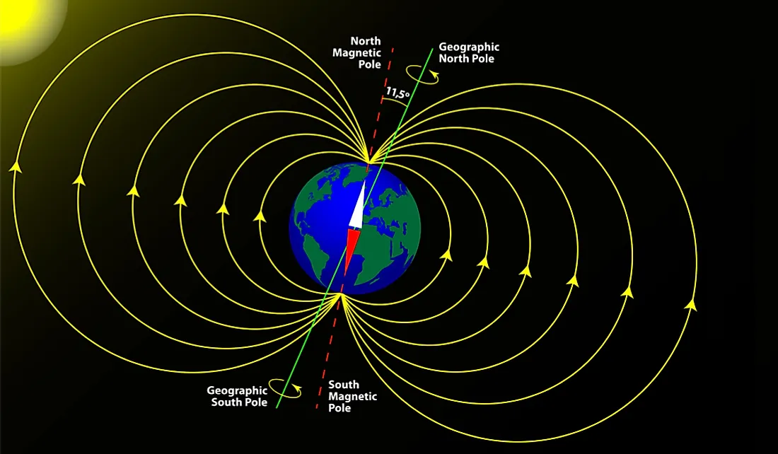
Distinguishing The Magnetic Pole From The Geographic Pole
The Magnetic North Pole is also called the North Dip Pole. It is located on Ellesmere Island. The needle in a compass points towards the Magnetic North Pole. The direction in which the compass points is different from the geographic north pole because the magnetic field around the earth formed by the dynamo of the Earth’s Core is slightly tilted from the Earth’s rotational axis. When one places a compass at the geographic North Pole, the needle will generally point towards Ellesmere Island in northern Canada where the magnetic north pole is located. The magnetic north is defined as the point where magnetic field lines point vertically down. Distinguishing between the geomagnetic north and the magnetic north is essential. The geomagnetic north is found in the northwest coast of Greenland and is the northern end of a planet-sized bar magnet. The magnetic north Pole is more susceptible to flows and surges in the swirl of hot liquid iron in the Earth’s Core. In 1831, the Magnetic North was found to be the scattered islands of Nunavut territory in Canada by James Clark Ross. It has since moved from the position that Ross established. The Geographic North Pole and the Magnetic North Pole are located about 310 miles apart. The difference is referred to as magnetic inclination.
Magnetic Inclination
Magnetic inclination can vary depending on one's position on the globe. To establish the right direction, navigators compensate for the magnetic inclination through the use of a chart of declination, also known as local calibration.
Earth’s Magnetic Field
Iron typically does not create a magnetic field even when it is molten. In a scenario where iron has a magnetic field when very hot, it would likely lose the magnetism as molecules would be knocking around so much that magnetic domains could hardly remain aligned. The Glatzmaier-Roberts model helps to explain how the magnetic field is created and why there is the occasional flip in the magnetic field. The model suggests that the Earth has a solid core made of iron that is surrounded by hot liquid metals. The movement or flow by the liquid metal in the earth's core rotates faster than the surface of the earth causing electrons to flow like a convective dynamo. The electron current results in the Earth Magnetic Field.
The Polar Shift Theory
The Polar Shift Theory explains the movement of the Magnetic North Pole. It is estimated that the Magnetic North pole has crept north over a distance of about 620 miles in the last 150 years. Scientists have previously determined the pole to be moving at the rate of 7 miles, but the rate has since increased to 34 miles per year and is heading to towards Russia. The magnetic north might get to Siberia over the next few decades. The increase in the rate of the Magnetic North's movement has not been fully explained. Some experts, however, point to the fact that a polarity flip occurred was about 800,000 years ago hence claiming that a polarity flip is long overdue.
Polar Reversals
Polar reversals refer to a situation when the compass could point to the south instead of the north. Scientists estimate that the Earth’s Magnetic field takes an estimated 200,000 to 300,000 years to flip polarity. The flip, however, takes thousands of years. The discovery that the Earth’s magnetic field has flipped in the past was made after sampling cooled magma that flew up out of the Mid-Atlantic Ridge which pushes Continental Europe and North America apart. After the magma cooled, it retained the magnetic field from which it was immersed. A sample of the magma indicated an alternating pattern of residual magnetism. Sample collected close to the ridge showed a magnetic field that was similar to that of the earth at the present day while the sample that was collected further from the ridge revealed a magnetic field that was opposite from that of the first sample collected close to the ridge. Another sample collected even further away from the second sample revealed a magnetic field change.
Ellipses of the Magnetic North
Usually, the location of the magnetic north forms an ellipse-like shape at any given day. The ellipse can vary due to the influences of the Sun. When the Sun impacts the magnetic field surrounding the earth considerably, the ellipse becomes large on what is referred to as "disturbed days."
The World Magnetic Model
To track the changes of the Magnetic North, the British Geological Survey and the US National Oceanic and Atmospheric Administration created the World Magnetic Model. The World Magnetic Model is updated every five years with the last update having been done in 2015. In between the updates, the accuracy of data is verified against the European Space Agency Swarm Mission which consists of magnetic-field mapping satellites that move around the earth about 15 times a day. The data is also verified against ground magnetic observatories. Scientists expect the Magnetic North Pole will continue its movement. Keeping up with the variation in the rate at which the Magnetic North Pole is moving is proving to be challenging.


