The Blue Marble: The "Out Of The World" Image Of The Earth
Background
In the first NASA satellite capture of the Earth on April 1, 1960, the image didn’t appear blue rather the infrared observation satellite known as TIROS beamed black and white images. The images showed that if an improved technology were used to observe the Earth from space, then weather forecast would be significantly improved. The NASA embarked on enhancing their technology after the 1960 observation to get a clear picture of the Earth with all the details including color and components of the Earth. Several pictures were taken from space with an improvement of each technology. In 1972 NASA made a breakthrough in capturing the image of the Earth
How And When Was The Image Captured?
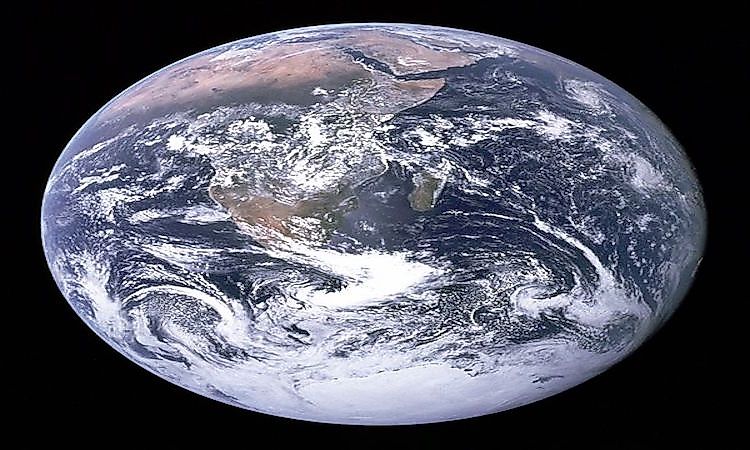
On December 1972, a crew of the Apollo 17 spacecraft captured a famous image of the Earth from a distance of 45,000 kilometers which has been known as the Blue Marble Image. The image is officially designated as AS17-148-22727 by the NASA. The photograph was taken by astronauts at 0539 hrs EST, 306 minutes after the launch of Apollo 17 and 114 minutes after the spacecraft took off from the parking orbit around the Earth. A 70-millimeters Hasselblad camera was used by the photographer to capture the image. The camera was fixed with an 80-millimeter Zeiss lens.
The Apollo 17 crew included Eugene, Ronald, and Jack and were the last to man an Apollo 17 for a lunar mission. The blue marble reproduces the images of the Earth traveling towards the moon as captured by the Apollo. The capturing of the Blue Marble is the first time the crew was able to capture the south polar ice despite the obstruction of the Southern Hemisphere by the clouds. The entire Africa’s coastline, Madagascar, and Arabian Peninsula are all visible from the image while the Asian mainland can be seen from the horizon. The Blue Marble inspired other images of the Earth captured by the satellite and the name has been used by NASA to refer to other series of images that also capture the globe with high resolution.
Subsequent Blue Marble Images
Similar images of the Earth have also been designated as Blue Marble images with the phrase “blue marble” frequently used by the environmentalists and organizations to promote environmental conservation and consciousness. A set of satellite images was released by NASA in 2002 including the prepared images for human viewing. Another set of images called the Blue Marble Next Generation was released in 2005 enabling the inclusion of cloud-free for each month of 2004. A composite image of the western hemisphere was released by NASA on January 25, 2012, and was titled Blue Marble 2012. The 2012 picture attracted over 3 million viewers on Flickr image hosting website. A companion of the Blue Marble 2012 covering the eastern hemisphere was released by NASA on February 2, 2012.
Deep Space Climate Observatory
NASA released new photographs of Blue Marble in July 2015 captured by the Deep Space Climate Observatory which was launched in February 2015. The photograph is centered over Central America including the US western side, Mexico, and the Caribbean. The image was captured on July 6, 2015, and released on July 21, 2015. With the advancement in technology, more images of the Earth are expected to be released more often by NASA.


