Highest Mountains In Myanmar (Burma)
The Republic of Myanmar, also commonly referred to as Burma, is a nation in the South East Asia region bordering Bangladesh, China, Laos, Thailand, and India. The country has a total land area of 676,578 square kilometers and lies between latitudes 9 Degrees North and 29 Degrees North and longitudes of 91 Degrees East and 102 Degrees East. Much of Burma lies within the Tropic of Cancer and equator in the monsoon regions of Asia. The country’s coastal area receives an annual rainfall of 5,000 millimeters. Myanmar has several mountain ranges including Bago Yoma, Rakhine Yoma, Tenasserim Hills, and Shan Hills. The mountains within the country run north to south from the Himalayas. The chain of mountains divides the country’s three rivers, the Salween, Irrawaddy, and Sittaung Rivers. The highest mountains in Myanmar are looked at herein.
Hkakabo Razi
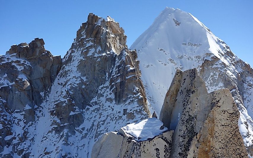
Hkakabo Razi is the highest point of elevation and the highest mountain in Myanmar with an elevation of 19,295 feet (5,881 meters). The mountain is also the highest in the South East Asia and it is found in the northern Myanmar state of Kachin in the Greater Himalayan mountain range. Mount Hkakabo Razi is surrounded by the Hkakabo Razi National Park which is entirely mountainous made up of the broad-leaved evergreen rain forest. The mountain is divided into zones depending on the level of elevation. The zones include sub-tropical temperate (8,000 to 9,000 feet), semi-deciduous forest, needle-leaves snow forest, and the alpine. Hkakabo Razi Mountain experiences an alpine climate with snow more common than rains especially during winter with a temperature range of between -60 Degrees Celsius and 23 Degrees Celsius. The first ascent of the mountain was made in 1996 by Takashi Ozaki and Nyima Gyaltsen. It took long for the first ascent of the mountain because none-citizens were not allowed into the area around the mountain until late 1993. Mount Hkakabo Razi and Hkakabo Razi National Park is rich in flora and fauna which have not been extensively studied or researched on.
Gamlang Razi
Gamlang Razi Mountain is thought to be one of the highest mountains in the Southeast Asia region. The mountain is found in northern Myanmar in the state of Kachin. The mountain was measured at 19,259 feet making it the highest mountain that has been verifued by the use of Global Positioning Satellites (GPS). Mount Hkakabo Razi is yet to be measured via GPS. Mount Gamlang Razi is within the Khakaborazi National Park and forms part of the Himalayan Mountain. The mountain is characterized by a year round glacier and snow while the rock type is granite. Mount Gamlang Razi’s first ascent was in 2013 by an American team and a team from Technical Climbing Club of Myanmar led by Andy Tyson. The climbing path to the peak passes through a thick rainforest and streams of water and it takes around two weeks to arrive at the base of the mountain.
Dindaw Razi
Dindaw Razi is among the highest mountains in Burma and South East Asia measuring 17,927 feet above sea level at its summit. The mountain is found in the northern Myanmar state of Kachin and outlays the ranges of Greater Himalayan Mountain near the border of China
Tami Razi
Tami Razi Mountain is the fourth tallest mountain in Burma and is also one of the tallest mountains in the South East Asia region. The mountain is located in the northern Myanmar state of Kachin outlying the ranges of the Greater Himalayan Mountain Ranges.
Madoi Razi
Mount Madoi Razi is located north of Putao in Myanmar. The mountain measures 15,144 feet forming one of the unique features of the Eastern Himalayan. Mount Madoi Razi is located within the remote plateau region in the rain shadow of the Madoi Madaing Razi. The mountain is home to several endangered wildlife species. The plant species found within Mount Madoi Razi are considered to be having medicinal values by the communities living around the mountain region.
Tani Razi
Mount Tani Razi is located in the state of Arunachal Pradesh, along the border between India and Burma, standing at an elevation of 15,026 feet above sea level. The mountain is characterized by a small summit area and a steep slope. Mount Tani Razi has no climbing record and very little has been reported in regard to it. It remains one of the least studied mountains in Asia. Mount Tani Razi is uninhabited with no communities living in the nearby. The mountain is surrounded by grassland. The surrounding area around Mount Tani Razi is mountainous in the south-east and hilly in the northwest. The region experiences an average annual temperature of -2 Degrees Celsius and an average annual rainfall of 1,800 millimeters.
Phangran Razi
Mount Phangran Razi rises to a height of 14,199 feet above sea level, and it is located on the border between India and Myanmar, 95 kilometers northwest of Putao. The vegetation covering the mountain varies greatly including bamboo forest, cloud forest, and rhododendron with the pine trees dominating the higher altitude. Wild animals especially the grazing types are very common in the Mount Phangran Razi. There are several long river valleys traversing to the foot of the mountain. Climbing Mount Phangran Razi is very tasking and demanding yet very rewarding. From the summit, climbers are able to view the great snow-capped mountains in the region.
Phonyin Razi
Mount Phonyin Razi is said to be one of the most rewarding peaks to scale in Burma. It is located in Burma close to the India border in the north western Myanmar Himalayan Range. The mountain measures 14,049 feet in height. Mount Phonyin Razi can be accessed from the town of Putao in the areas inhabited by the remote Lisu tribe villages. The areas around the mountain are covered by forest which is home to gibbons and langurs. The vegetation zones of the Mount Phonyin Razi include temperate forest, bamboo forest, and alpine pinewood forest.
Threats to Burmese Mountain Ecosystems
The mountains of Burma are biodiversity hot spots, characterized by diverse flora and fauna. However, the mountain regions continue to face several threats including human activities such as agriculture and logging leading to the habitat loss. Poaching of wildlife including mountain goats and wild buffalo is also a major threat facing these mountain regions. The government of Myanmar has declared these areas as protected areas as a conservation effort to prevent further habitat loss.
Highest Mountains In Myanmar (Burma)
| Rank | Highest Mountains in Myanmar (Burma) | Elevation |
|---|---|---|
| 1 | Hkakabo Razi | 19,295 feet |
| 2 | Gamlang Razi | 19,259 feet |
| 3 | Dindaw Razi | 17,927 feet |
| 4 | Tami Razi | 16,736 feet |
| 5 | Tasudo Razi | 15,883 feet |
| 6 | Madoi Razi | 15,144 feet |
| 7 | Tani Razi | 15,026 feet |
| 8 | Phangran Razi | 14,199 feet |
| 9 | Noi Madwe | 14,170 feet |
| 10 | Phonyin Razi | 14,049 feet |


