Ancient Egyptians Used The Nilometer To Predict Floods
What Is a Nilometer?
The ancient Egyptian Nilometer was a construction used during flood period that was experienced yearly, to help measure the levels of the Nile River’s waters as well as its clarity. A passageway of steps down to the river, a vertical column, and deep well with gutters were the three main types of nilometers calibrated in Egyptian cubits. While low levels of water were an indication of an approaching famine, high water levels would signal destructive floods. The nilometer had a definite mark indicating what height the floods would reach to provide the fields with good soil.
Why Was the Nilometer Necessary?
River Nile’s reaches which run through the country would occasionally burst their banks between July and November, covering the adjacent floodplain. Eventually, the waters would draw back in September or October, leaving behind the fertile alluvial deposits which comprised of extraordinarily fertile silt over the farmlands. The Egyptians at the time divided their years into three seasons of inundation also known as akhet being one of them. River Nile played a significant role to the Egyptian civilization through the annual flooding. In the region, the average inundation formed a crucial part in the annual agricultural cycle while a below average inundation would result in a famine. Similarly, an above average inundation would be similarly catastrophic thus leading to the destruction of a large portion of the nation’s infrastructure constructed along the floodplain. Between 622 and 999 CE, records indicated that one out of four years on average would experience flooding that did not meet the people’s expectations over the same period of about 102 of the years.
The Role the Nilometer in Egyptian Civilization
Certain individuals possessed the gift of predicting the volume of an incoming inundation, and this was some of the duties of the priesthood’s mystique in Ancient Egypt. Since the flood’s quality determined the levels of tax paid in the region in that given year, the skill of predicting floods also played a significant administrative and political role. This is the point in time when the daily use of nilometer on Nile River would be used daily to monitor the levels of water by priests who would then announce the arrival of long-awaited summer floods.
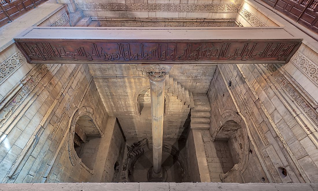
The Initial Design of the Nilometer
A vertical column sunk into river was the simplest design for the nilometer, and it was marked on intervals to indicate the depth or the level of the water. Even though housed in an ornate and elaborate stone structure, a nilometer that follows this design can be found in Cairo specifically in Rhoda Island. Tracing its existence back to 861 CE, this nilometer was constructed following the orders of the al-Mutawakkil and overseen by a Muslim astronomer known as Afraganus. The Nilometer was also constructed on site where an earlier structure was built; the earlier nilometer was ordered by Usama b. Zayd b. Adi in 715 CE, who was the head in collecting land tax at the time.
Other Nilometer Designs
The design of another nilometer comprised of stairs that led down to the Nile, it had markings that indicated depth on the walls. One of the best examples of this design is the nilometer seen on Elephantine Island in the city of Aswan; its stairway features 52 steps that lead down to another doorway to River Nile. The nilometer’s most intricate design featured a conduit or tunnel leading from the riverbank which frequently ran for a reasonable distance before feeding a cistern, tank, or well. Even though the nilometer originated from the Pharaonic times, several were constructed and used by later Egyptian civilizations while others were built during the Roman period.