A List Of Glacial Erosional Features Or Landforms
Although glaciers only cover about 10% of the Earth’s surface today, scientists estimate that millions of years ago, almost the entire surface of our planet was under ice and snow. Today, the erosional and depositional landforms left behind by these glaciers make the above fact evident. The study of these glacial landforms allows scientists to learn about the history of the Earth. It also helps them to predict future events related to glacial action on the planet.
Some of the most important glacial erosional landforms are as follows:
Cirque
A cirque, also known as a corrie, is a valley resulting from glacial erosion. It is shaped like an amphitheater with an opening on the downhill side and a steep cupped section with cliff-like slopes on three sides. The highest of these sides is called the headwall. The floor of this valley is bowl-shaped and receives the bulk of the impact of the ice flows from multiple directions and the accompanying rock particles and other debris. Cirques formed by glacial erosion are found in mountains in different parts of the world. The Upper Thornton Lake Cirque in the US national park of North Cascades is an example of a cirque.
Cirque Stairway
A series of cirques or glacially eroded rock basins arranged one above the other at different elevations, is called a cirque stairway. The Zastler Loch is one of the best-known examples of a cirque stairway. It is located in Germany’s Black Forest where it lies below the summit of the forest’s highest mountain of Feldberg.
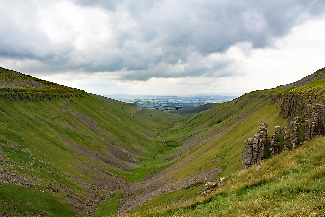
U-shaped Valleys
U-shaped valleys are glacier carved landforms that exhibit a characteristic U-shape. These valleys have a flat, rounded bottom. Their slopes are steep and roughly straight. These U-shaped valleys are formed by the scouring action of glaciers as they flow down slopes. After the glacier thaws or recedes, the rocky valley floor becomes visible. Small boulders called glacial till that were transported with the glacier often remain dispersed throughout the valley floor. U-shaped valleys can be seen in mountainous regions like the Himalayas and the Alps. The Nant Ffrancon Valley in Wales is a typical example of such a valley.
Arête
A narrow ridge of rock between two valleys is called an arête. The feature is usually formed as a result of glacial action. When two glaciers erode two parallel U-shaped valleys or two glacial cirques headwards, the ridge in between them stands out as an arête. The Clouds Rest is an example of an arête located in California’s Sierra Nevada Mountains.
Rôche Moutonnée
A rôche Moutonnée, also known as sheep rock, is formed by glacial action on the bedrock. It results in the formation of a rounded knob shaped mountain. The gentle upstream slope of the feature has a polished and striated surface formed by glacial scouring. The downstream slope, on the other hand, is formed by glacial scouring. It has a jagged, steep, and irregular surface. The ridge between these two slopes is perpendicular to the glacial movement.
Glacial Striations
When glaciers move, sand grains and bedrock at the base of such glaciers create striations in the form of gouges and scratches. When glaciers recede, such striations become visible on the bedrock. One of the best examples of glacial grooves can be seen on the Columbus Limestone in the Kelleys Island in Ohio. One of the grooves here is 400 ft long, 35 ft deep, and 10 ft in depth.
Glacial Horn/Pyramidal Peak/Nunatak
When multiple glaciers divulge from a central point by eroding cirques, the sharply pointed and angular ridge remaining in between the cirques is called a glacial horn. A pyramidal peak is the most extreme form of a glacial horn. Mount Matterhorn in Zermatt is an example of a pyramidal peak. A nunatak is also formed by a similar glacial erosional activity. It is a rocky outcrop located in an ice field or surrounded by glaciers that remain bare as its jagged and angular structure prevents the accumulation of ice. Nunataks are thus easily identifiable glacial erosional features. Greenland’s Queen Louise Land is an example of densely clustered nunataks.
Trim Line
A trim line is a sharp line on the hillside that marks the boundary between the poorly vegetated terrain that was previously covered under glacial ice and the well-vegetated terrain on the opposite side of the line. Trim lines are easily distinguished from the rest of the terrain due to the distinct color of the ground and the differential distribution of vegetation on either side of the line.
Hanging Valley
A hanging valley is another interesting landform formed by the erosional action of glaciers. Large glaciers usually carve out U-shaped valleys with a broad base and steep sides. However, tributary glaciers of the main glacier most often carve out V-shaped valleys that are shallower than that created by the main glacier. If the glaciers were originally flowing at the same level, erosive action will cause the shallower valley of the tributary glacier to hang above the valley of the main glacier. Thus, a hanging valley is formed in this manner. Waterfalls often drop down the edges of such hanging valleys. The Bridal Veil Falls in the Yosemite National Park is an example of a waterfall flowing down from a hanging valley.


