A List Of Glacial Depositional Features Or Landforms
Although glaciers cover only a small part of the Earth’s surface today and are constantly retreating due to climate change, the situation was very different in the past. Scientists believe that there were times when nearly the entire surface of the Earth was under ice and snow. The glacial erosional and depositional features visible on the surface of the Earth today serve as proof of the above fact. In this article, we will examine some of the depositional landforms created by glaciers and learn about how such landforms are formed. Most of these landforms became visible following the retreat of the glaciers that formed them.
Outwash Fan
When the braided streams of a flowing glacier deposit sediments on a flat plain, it results in the formation of an outwash fan. Usually, such landforms are produced by valley glaciers. As a glacier flows down the mountain slope, it picks up debris from the bedrock. After flowing through a valley, the glacier enters a wider and flatter plain. Here, it deposits the sediments in a fan-shaped body known as an outwash fan.
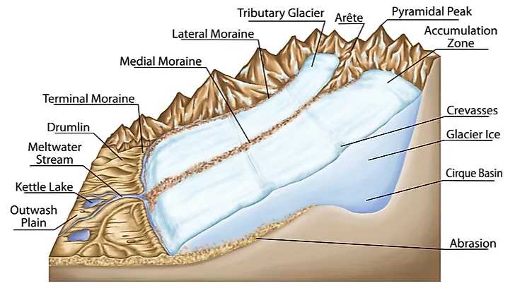
Moraine
A moraine is another glacial depositional feature. It consists of accumulated rocks, dirt, and other debris that have been deposited by a glacier. The size of deposits in moraines vary from tiny particles of sand to large boulders. The deposits accumulate on the surface in an unstratified manner without any type of sorting. Moraines are commonly occurring glacial landforms and are often seen in the Himalayan and Alpine mountain regions, Greenland, etc.
Kame
A kame is another depositional landform of a glacier. It is a hill or mound that lacks a proper shape. Kames are composed of till, gravel, and sand that can be observed after the retreat of glaciers. Such a feature is usually formed when debris from a rockfall or other large volumes of debris fall through a crevasse of a glacier and accumulate in the depression. When the glacier retreats, the kame becomes visible as an elevation of land on the bedrock through which the glacier previously flowed. Kames are common in Edmonton, Alberta where they make up the Prosser Archaeological Site. The Fonthill Kame located in Ontario, Canada, is also an example of a kame area.
Kame Terrace
A kame terrace is formed when the glaciers deposit sediments on the sides of a glacial valley. Usually, meltwater streams are formed on both sides of the glacier between the glacier and the valley walls. Such streams deposit sediments along their lengths in different layers. Such deposits appear like terraces on the valley sides and are called the kame terraces. Such terraces slope downward in the direction of the flow of the glacier.
Drumlin
Drumlins are depositional landforms formed by a glacier. A drumlin appears in the form of an elongated hill, a shape that can be compared with that of an inverted spoon or an egg buried partly. Drumlins are formed when glaciers move across till or rock debris. They mostly occur in flat lowland areas and extend in a direction parallel to the glacial flow. The drumlins are high and steep at glacier side and tapering and smooth on the lee slope. These landforms are usually found in clusters and often impede the movement of flowing water bodies. Thus, swamps and lake are formed between these landforms. Drumlins are common in Ireland.
Glacial Erratic
Erratics, as the name suggests, is a piece of rock that is different in several respects from the rocks of the surrounding landscape. Such rocks are carried by glaciers over long distances and deposited in a land where such rocks do not occur. The size of erratics varies from pebbles to massive boulders. An example of an erratic is Big Rock in Alberta.
Esker
An esker is also a depositional landform formed by glacial action. It exists as a long narrow ridge that winds along a glacial valley or canyon. Due to their peculiar shape, these landforms are often compared to railway embankments. Eskers are usually several kilometers long. They are made up of layers of gravel and sand. Eskers are formed when glacial channels running beneath, within or above a glacier, deposit sediments along their length of flow. Eskers usually form at the terminal region of glaciers where the flow of the glacier is sluggish in nature and is loaded with sediments. The Eiscir Riada is one of the best-known examples of a system of eskers. It runs for a distance of about 200 km covering nearly the entire width of Ireland from Galway to Dublin.


