A Complete List Of Fluvial Landforms
Fluvial landforms refer to landforms created by rivers and streams. It includes both erosional and depositional features created by these water bodies. When the rivers or streams are associated with ice sheets, ice caps or glaciers, then the use of the term glaciofluvial or fluvioglacial is more appropriate to describe the nature of the features produced by these acts of both ice and water.
River
A natural watercourse flowing through a channel is called a river. A river usually starts from its headwaters at a higher elevation and moves downslope till it ultimately drains into another water body like an ocean, lake or sea or even another river. As a river moves along its course, it creates several landforms by fluvial processes. Some of these landforms have been mentioned below.
Drainage Basin
An area where precipitation collects and drains into a common outlet of water like a river, lake, bay or another body of water, is called a drainage basin. The water entering the outlet has multiple sources like rainwater, snowmelt, tributary streams, and even groundwater. A drainage basin is also known as a watershed.
Channel
A channel is the path of a flowing body of water. It has two banks on either side and the depth and width of the channel varies depending on the nature of the bedrock and the force with which the river flows. A channel usually starts at a higher elevation where the water starts flowing between identifiable banks.
Confluence
When two or more water bodies join together to continue as a single stream, the area where they join is called a confluence. There can be different types of confluence such as the confluence of a tributary with the larger river, the confluence of the headwater streams of a river, or the rejoining of two channels of a river that had formed in the middle of its course.
Cut Bank
A cut bank refers to the outer bank of a river or stream that is continually subjected to erosion. The feature is also known as a river cliff as the river cuts into the bank to create a cliff-like landform. The cut banks are thus the outside banks of a meander as opposed to the slip-off slope on the inside of the meander.
Esker
An esker is a long and winding ridge composed of layers of gravel and sand. It is believed that these fluvial landforms were formed as the result of deposition of sediments by water flowing within and under glaciers. As the ice walls of the glacier melted away due to warmer temperatures, the eskers became visible as elevated depositional features.
Floodplain
A floodplain is a massive area stretching from the banks of a stream or river to the base of the enclosing walls of the valley. The area is susceptible to floods during a period of high discharge from the flowing water body.
Fluvial Terrace
Fluvial terraces are remnants of a previous floodplain or fluvial valley in the area that had a higher elevation than the floodplain or valley where the terraces can presently be observed. The terraces flank the two sides of valley or floodplain and appear raised about the rest of the surface. The terraces usually separate two floodplains or two fluvial valleys.
Canyon
When a river erodes the floor and walls of its channel located between two cliffs or escarpments, it results in the formation of a spectacular landform called a canyon or a gorge. The Grand Canyon is the most famous example of a canyon.
Gully
Gullies often look like small valleys or large ditches. This fluvial landform is produced by the erosion of soil on both sides of a running water channel. Gullies have steep slopes and are usually located on the hillside where water flows at a considerable velocity to carve out a gully.
Island
An area of sub-continental land surrounded by water is called an island. Such landforms can be the result of a large number of fluvial activities. Islands can be tropical, continental or oceanic in nature. Islands can also be artificially created by humans.
Natural Levees
A natural levee is a naturally occurring ridge that lies parallel to the course of the river in its floodplain. Such features usually protect the banks against flooding.
Meander
A river or stream never flows completely straight but snakes its way through the various undulations on the surface of the Earth. The river or stream thus forms a series of loops, curves or bends along its course and these features are called meanders. At the meander, the river erodes the outer convex bank and deposits the eroded material at the inner concave bank.
Oxbow Lake
An oxbow lake is a part of the river that has been cut-off from the main stem by deposits left by the river while meandering through its course. The feature resembles the bow pin of an oxbow, hence the name. The Crater Lake in Iowa, US, is an example of an oxbow lake.
Plunge Pool
A deep depression located at the base of a waterfall is called a plunge pool. Such a landform is created by the erosive action of water on the bedrock where it falls. The Seljalandsfoss plunge pool is an example of a famous plunge pool.
Point Bar
Point bars are depositional fluvial landforms that are very common in the meandering or mature streams. Such deposits are made of alluvium that accumulates on the inside bend of the river or stream below the slip-off slope.
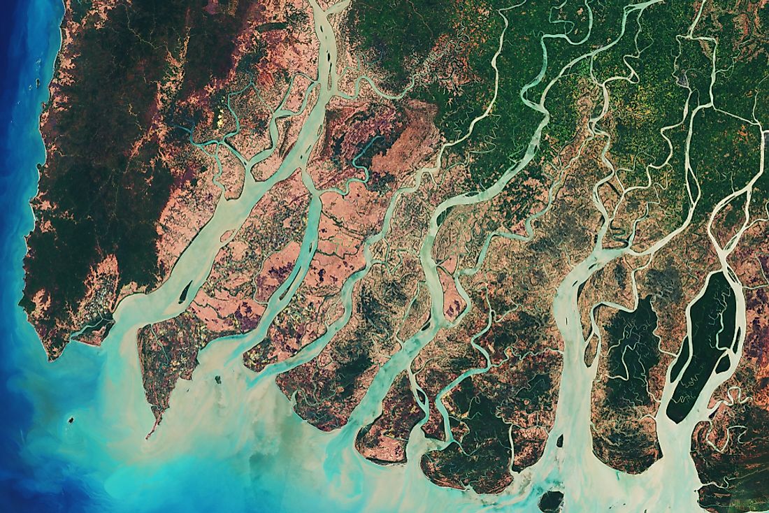
River Delta
When a river reaches its lower course, it loses speed and unloads itself of the sediments carried with it. As the sediments accumulate, the river branches out into a number of distributaries to allow the waters to make way through the deposits into the sea, ocean or lake where the rivers drain itself. Such an area is called a river delta and is usually an ideal location for agriculture as the soil here is highly fertile. The Ganga-Brahmaputra delta in the Indian subcontinent is one of the most fertile and densely populated deltas in the world.
River Island
An exposed area of land within a river is called a river island. Various factors can lead to the formation of such islands like changes in the course of a river or the opposing actions of deposition and erosion working simultaneously, etc. The Majuli island on the Brahmaputra River in India is an example of a river island.
Shoal
When a ridge, sandbank or sandbar that has been submerged by water appears on the surface of the water, it is called a shoal. Such features often pose a great danger to navigation.
Spring
A spring is an outlet of water through which water flows from an underground aquifer to the surface of the Earth. Springs are common in areas with karst topography.
Stream
A stream is a flowing body of water. It flows within the bed and banks of a water channel. Larger and longer streams are called rivers. The names of streams vary with their location.
Stream Pool
A part of a river or a stream where the depth and velocity of water are above average and below average of that of the entire river, respectively, is called a stream pool. Such features are common in the outer edges of the meander of the water body.
Riffle
A riffle is the quite the opposite of a stream pool. It is a relatively shallow part of the stream where the water moves at a faster speed. The water surface in the region is wavy and disturbed.
Valley
An area between mountains or hills that usually has a river running through it is called a valley. This fluvial landform is carved by a river as it erodes the walls of the mountains or hills while flowing from a higher to a lower elevation. Valleys can also be excavated by glaciers in a similar manner. The Yosemite Valley in the US is an example of a glacier-carved valley.
Waterfall
A waterfall, as the name implies, refers to water falling over a vertical drop or a series of such drops in the course of a stream or a river. Waterfalls may also occur at the edges of glaciers or icebergs in the area where meltwater forms and drops down a vertical height. The Angel Falls in Venezuela is an example of a spectacular waterfall. It is the highest uninterrupted waterfall in the world. The Angel Falls is ocated on the course of the Rio Kerepacupai Meru river that flows into the Churun River.
Yazoo Stream
When a stream or a tributary river flows parallel to the floodplain of a larger river for a considerable distance and then joins the latter, the tributary is called a yazoo stream. The Yazoo River is an example of a yazoo stream. It runs parallel to the Mississippi River for a distance of 280 km before joining the river.


