Which Countries Border Lesotho?
Lesotho, previously known as Basutoland, is an enclaved state in southern Africa. Lesotho has over 2 million residents and occupies an area of about 11,583 sq miles. Basutoland was established by the British in 1884, and it had seven districts; Mafeteng, Qacha’s Nek, Berea, Mohale’s Hoek, Quthing, Maseru, and Leribe. The country was renamed Lesotho after they gained their independence on October 4, 1966. Lesotho is a member of the SADC (Southern-African Development Community), the Commonwealth, and the United Nations. The largest and capital city of Lesotho is Maseru.
The country is governed as a parliamentary monarchy with King Letsie III being a ceremonial figure. The Prime minister has executive authority and serves as the head of the government. The Senate is made up of twenty-two principal chiefs and eleven appointees of the monarch who advise the prime minister. Their judicial system is made up of the traditional courts (found in rural regions), Magistrate’s courts, Court of Appeal, and the High Court. Lesotho has no jury, and the judges make all rulings. In criminal cases, the judge is usually joined by two more judges as bystanders.
Countries Bordering Lesotho
The Lesotho-South African Boundary is about 565 miles long and creates a complete loop since South Africa enclaves the state. The boundary follows the Makhaleng River, Orange River, Tele River, the Caledon River, and Drakensberg Mountain’s drainage divide.
South Africa
South Africa is the southernmost African state and the twenty-fifth biggest in the world. It is the southernmost state on the Eastern Hemisphere. South Africa is surrounded by Zimbabwe, Namibia, and Botswana to the north, Swaziland to the northeast, and Mozambique to the east. South Africa has a 1,739-mile long coastline stretching along the Indian Ocean and South Atlantic Ocean. South Africa occupies an area of about 471,445 sq miles and has over 57,725,600 residents. Over 80% of the locals are of Sub-Saharan ancestry. It is a parliamentary state with the president serving as the head of both the state and the government.
Lesotho-South Africa Border
History of the Lesotho-South Africa Border
The Basotho community established a polity under a paramount chief in the 1820s. During that period the Basotho territory included a huge part of the present-day Free State Province. Lesotho became a British colony in 1868 after losing a series of battles against the Boers from Orange Free State. The Lesotho-South Africa boundary was defined in the Aliwal North convention of 1869. It was confirmed by the notice of the High Commissioner of May 13, 1870, and amended by the government on November 6, 1871.
Geography of the Border
From the Mont-aux-Sources, the boundary stretches along the drainage divide between various rivers which originate from Drankensberg and Orange River’s basin. The border runs to the source of River Tele before following the river to its confluence with River Orange and then extends to where River Makhaleng meets with Orange River. The border stretches along River Makhaleng to a certain point on the western part of Mohale’s Hoek before flowing through numerous hills to River Caledon. It then follows River Caledon through Ficksburg (South Africa) and Maseru to its source at Quaneka Neck. The border then extends between Vaal River and Orange River basins to Mont-aux-Sources. The ten provinces in Lesotho and three South African provinces touch this border.
Border Crossings
Maseru Bridge
Maseru Bridge is one of the official border posts on the South Africa-Lesotho boundary which carries the N8 road. The N8 connects Bloemfontein, Kimberley, and Upington in South Africa to Maseru, Lesotho. The national route originates from Groblershoop, Northern Cape and extends east to Kimberley through Griquatown. It runs through Free State to Bloemfontein before stretching through Ladybrand, Thaba Nchu, and Botshabelo to the boundary at the Maseru Bridge.
Maputsoe-Ficksburg
Another border crossing is in the town of Maputsoe in Leribe, Lesotho. The town shares a boundary with Ficksburg, South Africa. Maputsoe has a population of over 55,541 residents. Ficksburg is on the foot of Mountain Imperani in the province of Free State. General Fick founded Ficksburg town in 1867.
Tele Bridge
Tele Bridge is a steel motor bridge which spans over River Tele (one of the branches of River Orange that flows through South Africa). Tele Bridge is a boundary post between Lesotho and South Africa. The Bridge links Quthing, Lesotho to the Eastern Cape of South Africa. Donald Woods, an anti-apartheid journalist of the Daily Dispatch, used the Bridge when he was escaping from South Africa in 1977.
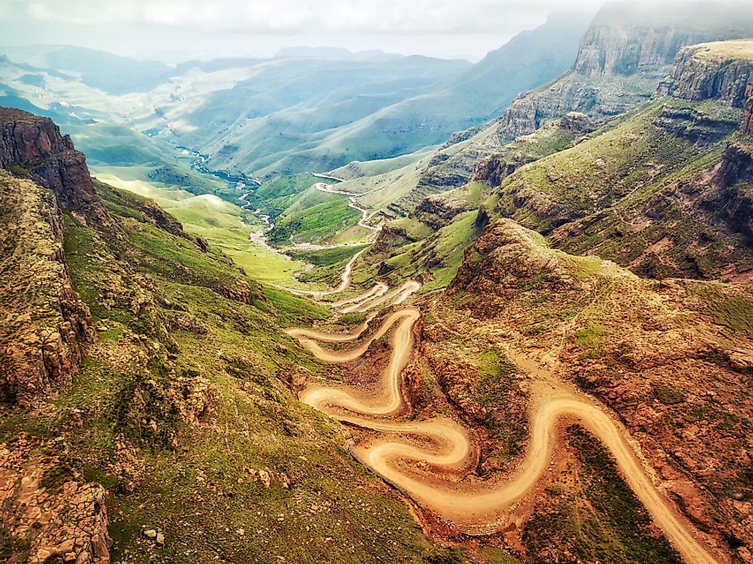
Sani Pass
Sani Pass serves as a border crossing between South Africa and Lesotho. The mountain pass is situated on the western parts of KwaZulu-Natal on the road between Mokhotlong, Lesotho and Underberg, South Africa. The route begins at an elevation of about 5,066 ft and then climbs to an altitude of about 9,436 ft above the sea level. Driving on this road can be very difficult especially in bad weather; therefore only four-wheeled vehicles are allowed to use this route from South Africa. The Lesotho officials at the peak of the pass allow all cars to descend. The pass is about 5.6 miles long and lies on the border control of both countries.
Other Border Crossings
Other crossings include Sepapu’s Gate and Makhaleng Bridge which spans over River Makhaleng.