Charles River
Also referred to as River Charles, the Charles River is a 129 km long river that flows in the eastern portion of the US State of Massachusetts and is the longest river that flows entirely within the state. The river begins at Echo Lake in the town of Hopkinton and then follows a highly meandering route flowing through 23 towns and cities in the eastern portion of the state, finally draining into the Boston Harbor. The Charles River drains an area of 798 sq. km.
Geography Of Charles River

The Charles River originates at Teresa Road, located just to the north of Echo Lake in the town of Hopkinton in the Middlesex County of the US State of Massachusetts. The river follows a highly winding course that doubles back on itself numerous times and is fed by more than 80 streams and several other principal aquifers. This 129km long river drains a large area of 798 sq. km and contains 33 lakes and ponds and 35 municipalities that wholly or partially form a portion of the drainage basin of the Charles River. It is to be noted that despite the Charles River’s long length and large drainage area, the distance from the source to the mouth of the river is only 42km, and the river drops approximately 107m while traversing the entire length from its starting point to the sea. More than 32 sq. km of wetlands within the Charles River watershed have been protected from development as part of the “Natural Valley Storage” Project. These wetlands provide critical natural habitats for the native species and help prevent downstream flooding.

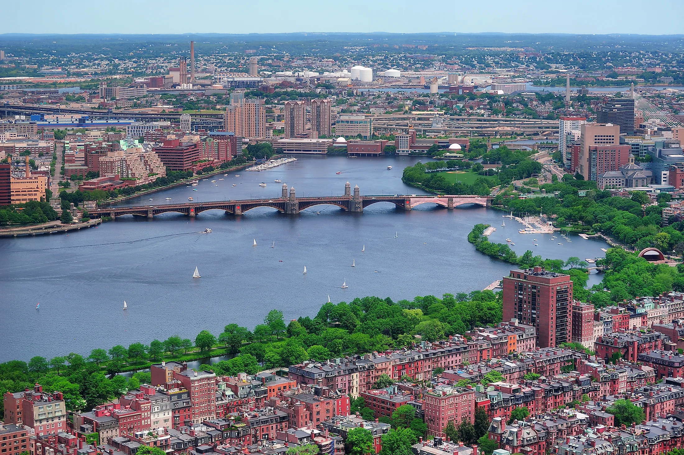
Several significant Academic institutions are located along the Charles River, including Boston University, Brandeis University, Harvard University, and the Massachusetts Institute of Technology. The middle segment of the Charles River from the Watertown Dam to the town of Wellesley is partly protected by several state parks of the Upper Charles River Reservation, including Cutler Park, Elm Bank Reservation, the Hemlock Gorge Reservation, etc. The Charles River Esplanade hosts more visitors than the country’s other riverfront parks, especially during the Independence Day celebrations. Close to its mouth, the Charles River forms a boundary between downtown Boston, the Charlestown neighborhood, and the city of Cambridge. A dam has been built close to the mouth of the Charles River, where the dam’s navigation locks provide access to the harbor and act as a barrier that prevents saltwater intrusion from the Atlantic Ocean. The Charles River, after flowing through 23 towns and cities in the eastern portion of the State of Massachusetts, finally drains into the Boston Harbor, with an average discharge of 8.6 cubic meters of water per second.
Recreational Facilties

The Charles River is navigable for only 27km from the Museum of Science to the central part of the city of Watertown. Except for the winter months, the Charles River offers several outdoor recreational activities such as sailing, kayaking, canoeing, rowing, paddle boarding, sculling, etc. The Head of the Charles Regatta, the world’s largest long-distance rowing head race, is a two-day rowing event held every year on the fully penultimate weekend of October. Many boathouses along the Charles River, including Community Rowing Inc., Newell Boathouse, Weld Boathouse, etc., offer competitive, recreational, and learning programs. The 37km long Charles River Bike Path that runs along the shores of the Charles River is popular with bikers and runners.
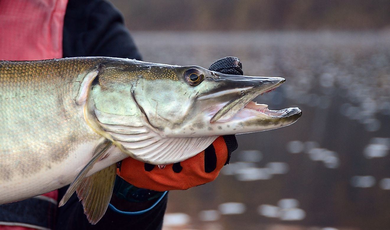
Wildlife
A wide range of diadromous and freshwater fish species are found in the Charles River. Some of the common freshwater fish that have been recorded here include Golden Shiner, Largemouth Bass, Redfin Pickerel, Yellow Perch, Redbreast Sunfish, Brown Bullhead, Yellow Bullhead, etc. Some anadromous species such as American Shad, Striped Bass, Alewife Herring, and White Perch are also found in the Charles River. The American Eel is the only catadromous fish found in the Charles River.
Brief History Of Charles River

It is believed that much before the European colonization, the Charles River formed a significant part of the lives of Native Americans that lived in the New England region. In the early 1600s, when the Europeans first arrived in the region, the area along the Charles River was inhabited by the native Massachusett tribe. The native people referred to the river as “Quinobequin,” which meant “meandering” in reference to the river’s highly winding course. In the 1620s, the English Captain John Smith explored and charted the entire coast of New England and named the river as “Massachusetts River” after the indigenous Massachusett tribe. After Smith presented his map to King Charles I, the King rechristened the “Massachusetts River” as the “Charles River.” With the arrival of the Europeans, the Charles River started becoming an early center for hydropower and manufacturing in the North American continent. In 1639, the early settlers in the town of Dedham dug a canal from the Charles River to an adjacent brook that, in turn, drained to the Neponset River. This canal is regarded as North America’s first industrial canal, and stills remain in use for flood control. By the 19th century, the Charles River area became one of the most industrialized areas in the United States. By the end of the 19th century, about 20 dams had been built across the river to provide power to the industries. More than 20 parks and natural areas are located along the 31km long shoreline of the Charles River, stretching from the New Dam at the Charlestown Bridge to the dam located close to the Watertown Square. However, by 1955, due to the discharge of industrial wastewater, sewage, and urban runoff, the Charles River became well known for its high level of pollutants. The river’s high pollution levels forced the state authorities to ban several popular swimming areas along the Charles River. In 1965, the Charles River Watershed Association was created to fasten the efforts to clean and restore the Charles River.