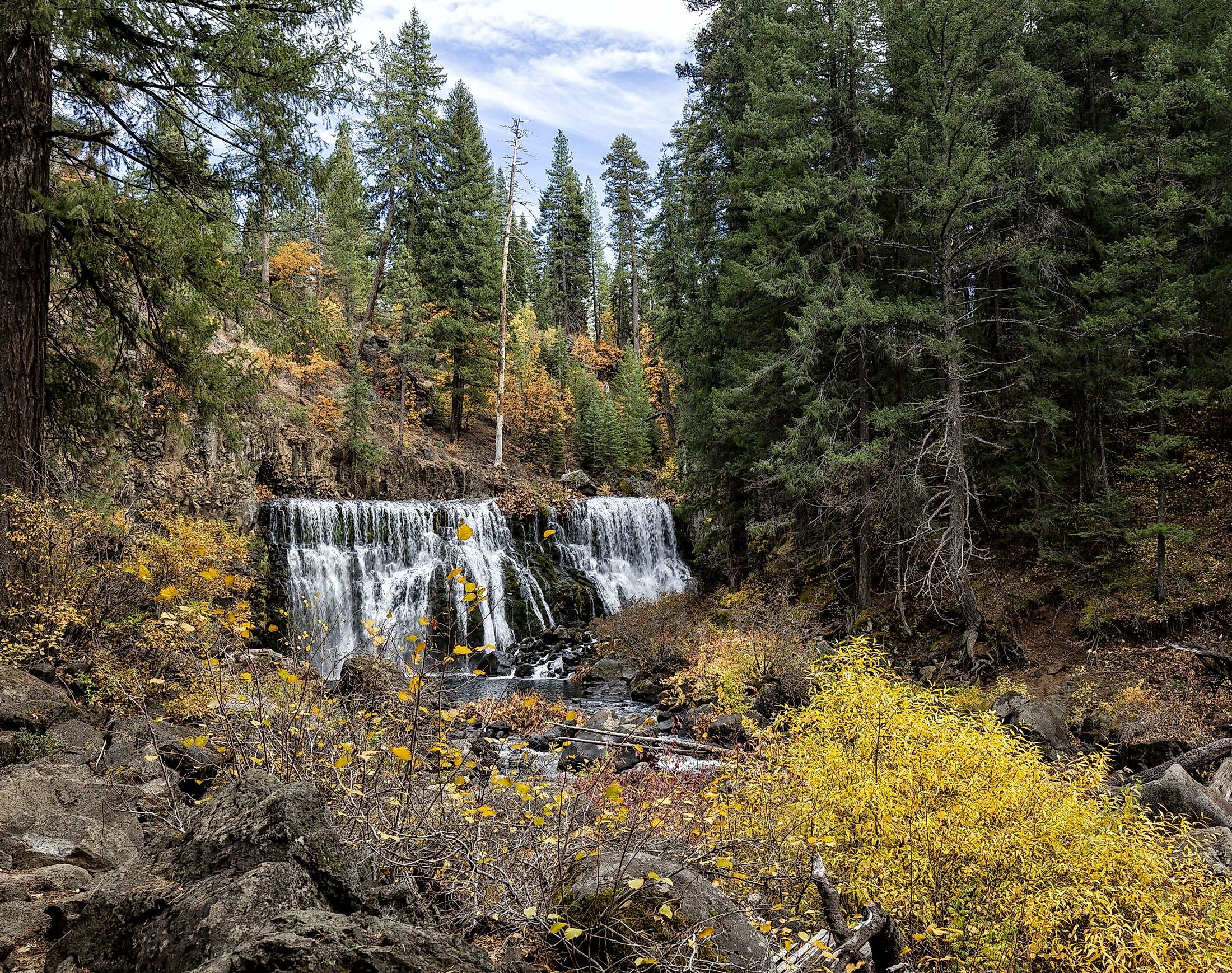
McCloud Falls, California
Not one, not two, but three waterfalls found within a couple of miles of each other, McCloud Falls in California is a hidden gem close to Mount Shasta. Resting at the southern edge of the Cascade Mountains, the McCloud Falls features geologically intriguing columnar basalt encased by the high desert forest of hemlock redwood, fir, and pine trees. With a campground, fresh spring water to swim in, and numerous cliffs offering scenic vistas, McCloud Falls is a popular stopover for families and outdoor recreational enthusiasts.
Geography Of McCloud Falls

The McCloud Falls can be found in north-central California, just east of the city of McCloud. Known for wide expanses of wilderness, including mountains, forests, and lakes, this region attracts those from the big cities to the south for its raw and untouched nature. With four seasons to boot for outdoor recreation, from camping, hiking, and rock climbing to skiing on snow-capped mountains, visitors have many options at their disposal. McCloud Falls resides in Shasta-Trinity National Forest, along with the 14,179-foot summit of the active stratovolcano of Mount Shasta. As for the McCloud Falls, the cascades are best known for their names, Lower, Middle, and Upper Falls, which are spread out along the McCloud River, which is a tributary of the Pit River. On an additional note, the 77 miles long McCloud River is a protected waterway under California’s Wild and Scenic Act of 1972 and runs parallel to the nearby Sacramento River.
Geology Of McCloud Falls

Mount Shasta is the primary source of the columnar basalt found throughout the McCloud River Basin. Of the other volcanoes located in the Cascade Mountain Range, Mount Shasta is the fourth highest and the second highest in the state of California. It consists of an overlap of four volcanoes that have propped up its form. Through carbon dating initiated by the Smithsonian Institute's Global Volcanism Program, the last time Mount Shasta erupted was approximately 1250 AD. Of Mount Shasta's cones, the closest to the McCloud waterfalls is called Misery Hill, which formed about 20,000 years ago. Furthermore, like most of Mount Shasta, Misery Hill was created through a process of pyroxene andesite flows. As for the McCloud River Basin, columnar basalt is abundant around the river bed. Basalt lava burns hotter than other variations of lava and is less dense. The result is the peculiar-looking columns that are a geological feature in the Shasta-Trinity National Forest. Concerning the large amount of mud found in this forested region, this is also due to the venting of the volcano that at one time spurted mud from volcanic mudflows. The United States Geological Survey monitors the seismology of Mount Shasta, and although there has not been any volcanic activity in 15 years, the nearby volcano is rated as being very high risk, with pyroclastic flows being a possibility.
History Around McCloud Falls
In the area around the falls, activities like hunting and trapping for the fur trades were common in the early 19th century. One trapper of note is Alexander Roderick MacLeod, who worked for the Hudson’s Bay Company. Around 1829-1830, MacLeod explored the region during a cold winter. It is largely speculated that his name stuck among fur traders as a way of recognizing the river way. The 1860s saw the name change adjusted for American spelling, from what was then MacLeod became McCloud.
Hikes Of McCloud Falls

Each waterfall can be driven to and accessed by its individual parking lot. The best way to see all three waterfalls is via the McCloud River Trail, which is an easy trek that lasts 3.8 miles. Commencing at the Lower Falls, a paved trail will take visitors to the smallest of the three waterfalls. The 12-foot drop expels the McCloud over a basalt ledge. It is to be noted that although this is a popular cliff jumping area, recent erosion has dropped new boulders into the well-known swimming area. Don’t forget to check out the observation platform before heading to the Middle Falls. At this time, the trail will turn to a gravel trail, tracing the edge of the McCloud River. It is typical for increased foot traffic along this stretch of trail heading to the Middle Falls, with campers from nearby Fowler’s campground. However, this should not deter visitors from seeing this watery spectacle. The basalt creek will break away, and the forested canopy overhead will increase to showcase a 50-foot tall and 100-foot wide waterfall. Here is an overlook that allows all to see the grandeur of the Middle Falls with its swirling pools below. Just be cautious since the trek up to the overlook is steep. Lastly, the trail to the Upper Falls takes hikers down a winding path and offers the thickest canopy overhead from the beating sun. This paved trail allows views of a narrow gorge where the McCloud River plunges 25 feet. At this point, many visitors opt to head back to the trailhead. However, if you continue, you can see the Lakin Dam. The trail opens up to offer views of the surrounding meadow and picnic areas. As for all the waterfalls on this trail, it is best to show up early, as the area is halftime to the nearby campground and see a high volume of hikers and swimmers.
The McCloud Falls is one of the most popular spectacles found in the Shasta-Trinity National Forest. With nearby campsites that serve as a leaping-off point to the series of waterfalls, the area attracts many for four-season outdoor recreation. Anyone who is traveling to northern California will not want to miss this awe-worthy natural landscape.