Aniva Bay
A small inlet known as the Aniva Bay lies off the southern tip of Russia's largest island at Sakhalin. Aniva Bay may not be as famous as many other major bays and gulfs, but features unique geography and biodiversity that sets it apart. There are also a few landmarks and points of interest situated near or around Aniva Bay that may perplex a curious traveler.
Where Is Aniva Bay?

Aniva Bay is located off Sakhalin Island, between the Sea of Okhotsk and the Sea of Japan. This inlet lies at the southern tip of Sakhalin, with the Kuril Islands to the east. Japan's second largest island, Hokkaido (particularly the city of Wakkanai), also lies south of Aniva Bay. There is also some human activity recorded or present around Aniva Bay.
Geography Of Aniva Bay
Aniva Bay constantly interacts with waters from the Sea of Okhotsk and the Sea of Japan. These water bodies (among others) influence the hydrophysical features of the Bay because of their tides and atmospheric conditions. The hydrological processes of Aniva Bay are also influenced by two interacting currents: the East-Sakhalin current warming the Soya current.

These currents and the interacting water bodies also influence the variable climatic regions of the Bay's coasts. For instance, the Cril'on Peninsula experiences snowy winters and warm summers due to the warm Soya current. Meanwhile, due to the cool waters in the Sea of Okhotsk, the Tonino-Aniva Peninsula undergoes cool summers and warm winters.
Aniva Bay is relatively small, with an area of about 5000 km2. Its coastline also stretches over 143 miles. In the northern part of Aniva Bay, the depths are at most 40 meters. However, the Bay's seaward boundary can harbor depths of about 328 to 361 feet. There are over 140 unique watercourses that flow into Aniva Bay. Of them, there are only ten rivers that span over 12.4 miles, which include the rivers Lyutoga, Susuya, Taranay, and Uryum. Others do not exceed a length of 6.2 miles.
Wildlife Of Aniva Bay

The Bay experiences a diversity of fish fauna during the fall and summer seasons. Based on data in the past 200 years, there have been 274 fish species recorded to be present in Aniva Bay, including varieties like smelt, capelin, saffron cod, and herring. In fact, of over 140 watercourses that flow into Aniva Bay, 80 of them are suitable spawning grounds for salmonid fishes. It's also estimated that there are 30 rivers that behave as spawning grounds for anadromous fish species like pink salmon. Specifically, pink salmon may migrate in large numbers across Aniva Bay. In total, it's estimated that the rivers which flow into the Bay that behave as spawning grounds for fish include an area of approximately 2 million m2.
Fish populations at Aniva Bay comprise a large biomass and support diets for larger species, including the spotted seal. Shorebirds have also been observed at the Bay, including species like the grey-tailed tattler and red-necked stints. Several species from Japan have also been observed in Aniva Bay. Populations of whopper swans (Cygnus cygnus) were also observed in Aniva Bay as a "stopover site" during migration. Overall, it's estimated that there are over 20,000 waterbirds and 10,000 breeding pairs of seabirds at the Bay.
Human Presence At Aniva Bay

Aniva Bay was once regarded as a prolific salmon fishing area due to its abundance of pink salmon. However, Aniva Bay was historically subjected to overfishing, unregulated fishing activities, and impact by the nearby oil and natural gas industry. There have been outreach efforts to enhance awareness of illegal and detrimental fishing activities around Aniva Bay, particularly pertaining to its salmon population. Efforts included the promotion of recreational fishing licenses and fishing with spinning or fly rods.
Landmarks In And Around Aniva Bay
Sakhalin is well-known for its natural landscape, including waterfalls, hot springs, volcanoes, and mountains. Specifically, several landmarks around Aniva Bay have attracted tourists visiting the southern end of Sakhalin Island, from the country's most inaccessible lighthouse to the giant oysters at the local lagoon.
Aniva Lighthouse

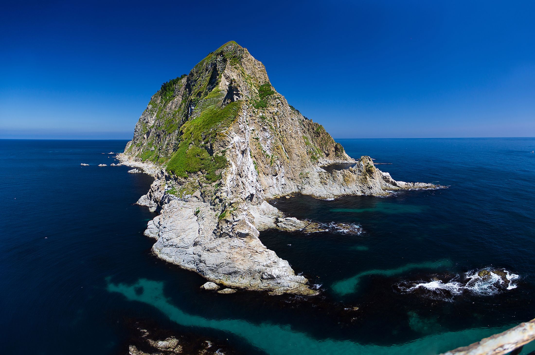
The Aniva Lighthouse is Sakhalin's most famous lighthouse. Getting to this abandoned lighthouse is a challenge, and it's no wonder they named this landmark the most inaccessible lighthouse in Russia. The Aniva Lighthouse sits atop a small rock near Cape Aniva. The area around the lighthouse experiences strong tides and sea mists. In fact, there are many shipwrecks around the area too.
It took over two years to build this lighthouse, which finished around 1939. The concrete lighthouse was built about 102 feet tall with nine floors. The lighthouse was designed for living in harsh weather conditions, which included living quarters (that could fit up to 12 people) and a basement for engines and batteries.
Yuzhno-Sakhalinsk

Yuzhno-Sakhalinsk is the primary city of the island, on its southern end. Locally referred to as "Yuzhnyy," many people living in Yuzhno-Sakhalinsk are connected to the oil and natural gas industry. The city was founded in 1882 as a convict settlement named "Vladimirovka." From 1905 to 1945, Japan took over the settlement, renaming it "Toyohara," and established an urban plan for the area. Today, the city houses architecture that encompasses designs from the Soviet and traditional Japanese buildings.
Yuzhno-Sakhalinsk experiences a continental-style climate; a thick mist often covers the city. In the colder season, it's common to see fog around the city's streets. The city has several points of interest, including the Sakhalin Regional Museum, Gagarin Park, the Museum of Local Lore, and the Devil's Bridge.
Lake Busse

Though it's called a lake, Busse is a lagoon and goes by several names, including Lake Vyselkovoye or Maloye Busse. This saltwater body connects to the Sea of Okhotsk at the southern tip of Sakhalin Island. This water body is about 2.8 miles deep, 5.6 miles long, and 4.3 miles wide. This Sakhalin lagoon houses several species, including Far East sea cucumbers, scallops, sea urchins, mussels, shrimps, smelt, herring, salmon, and various fish species. However, Busse is famous for its population of giant Sakhalin oysters.
In fact, during low tide, beds of giant oysters can be found along the banks of Busse. These oysters may weigh as much as 3.3 lbs and span about 7.9 inches long. Sea urchins are seen habituating between the oysters, while algae species can also be found nestled around the shores of Busse.
Aniva Bay may not be as well known as the world's famous water bodies like the Gulf of Mexico or Crater Lake. However, its geography, wildlife, and remoteness may perplex curious travelers.


