The Yalu (Amnok) River
5. Description
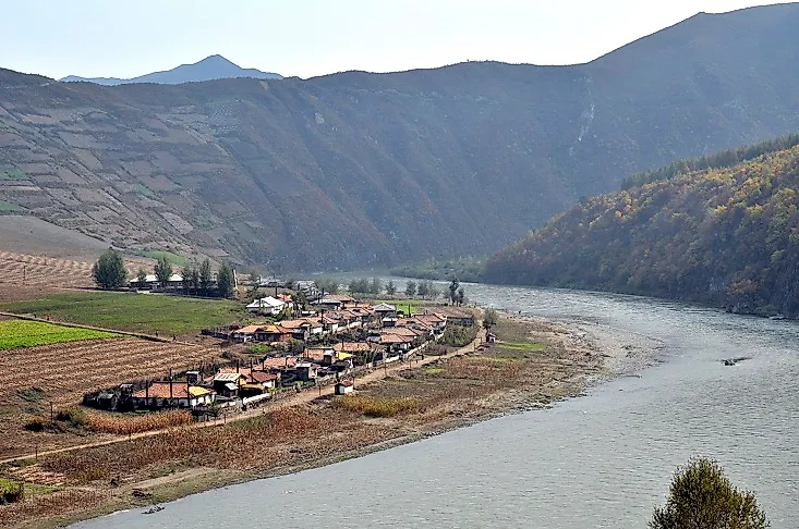
The Yalu River, also known as the Amnok River, is an 800-kilometer long river in northeastern Asia forming the natural boundary between northwestern Korea and northeastern China. The river arises from the Tian Lake on top of Mount Paektu in the Changbai Mountains (which form the border between the Chinese provinces of Jilin and Liaoning and North Korea), and drains into the Korea Bay between Dandong in China and Sinuiju in North Korea, occupying a basin of 31,750 square kilometers. The Tokro, Ai, Hochon, and Changjin are the major tributaries of the Yalu River. 200 islands belonging to either China or North Korea exist on the river.
4. Historical Role
In the ancient world, the Yalu River Basin served as the site of the ancient Korean Kingdom of Goguryeo, which established a number of forts along the river, the evidence of which exists to this date. The Yalu River, by virtue of its strategic location, has also borne witness to a number of major battles and warfare of more modern times, such as the 1894 Sino-Japanese war and the 1904 Russo-Japanese War. During the Korean War of 1950, all bridges on the river between China and North Korea, except for the Sino-Korean Friendship Bridge between Dandong, China, and Sinuiju, North Korea, were destroyed.
3. Modern Significance
The Yalu River not only acts as the political boundary between North Korea and China, but also serves as a cultural boundary between these two countries. The river is also an important source of hydroelectric power generation, and several dams and hydroelectric power stations, like the Sup'ung Dam, the Taipingwan Dam, and the Yunfeng Dam, have been built upon the river. The Sup'ung Dam is one of the largest hydroelectric power stations in Asia, with a capacity of generating around 7 million kilowatts of electricity. Only about 89,000 hectares of land are arable along the river basin, and most of this is used for growing rice, corn, millet, and sweet potatoes. Fishing in the Yalu River also sustains the livelihoods and helps meet the protein needs of the Chinese and Korean populations settled along the river.
2. Habitat and Biodiversity
The Yalu River basin experiences a continental climate characterized by extremes of temperature. While summers are warm, winters are frigid, and the river remains frozen for four winter months. A fairly high amount of precipitation is received between the months of June and September. The climate of the Yalu River basin thus supports the growth of coniferous and deciduous forests of pines, birches, and oaks. Wild fauna of the region include such mammals as wolves, tigers, foxes, and bears, as well as birds like pheasants and ptarmigans, while several species of fish live in the river itself.
1. Environmental Threats and Territorial Disputes
Though environmental threats induced by pollution and damming of the Yalu River exist, the river also forms a potential site for territorial disputes between the two nations sharing its waters. The greatest problem is with the existence of the large number of islands on the Yalu. Though the inhabited islands are claimed by the country whose population resides on them, it becomes difficult to manage the uninhabited islands. Tension also exists between the two countries regarding the sharing of the river's ports and the Yalu River Delta.


