What Are The Differences Between Windward And Leeward Islands?
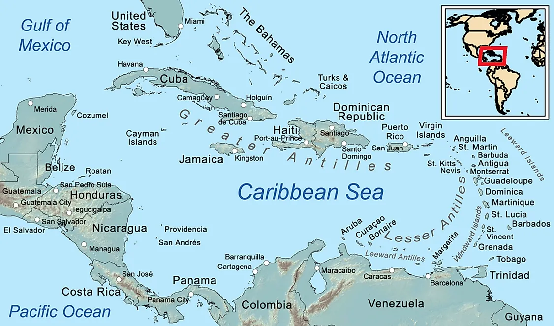
The Windward and Leeward Islands are groups of islands comprising the Lesser Antilles in the Caribbean. The majority of the islands are small and uninhabited while the larger ones have become sovereign countries.
The Windward Islands
The Windward Islands are the islands located to the east of the Caribbean Sea and are the southern part of the Lesser Antilles. These islands include Martinique, Saint Lucia, Grenada, Dominica, and Trinidad and Tobago. However, the islands of Trinidad and Tobago are geologically linked to the South American continent. The island nation of Dominica was governed as part of the Leeward Islands while being under British colonial rule. The islands have had a history of volcanic activity some of which are still active. The May 1902 eruption of Mount Pelee was one of deadliest in the island's history and killed over 30,000 people.
The climate experienced on the islands is the usual warm and wet tropical climate with an alternating wet-dry season. During the Transatlantic Slave Trade, ships would first encounter these islands before moving to North America. These islands are known as “Windward” due to their position where they are on the path of the northeastern trade winds. The ancient traders who used sailing ships used wind to navigate their vessels hence the reference. The Spanish named all islands east of Puerto Rico as Islas de Barlovento which translates to “windward islands” while the islands south of Puerto Rico were referred to as “Sotavento” meaning “leeward islands.” Most of these islands were initially French colonies and were referred to as the French Antilles. The Windward Islands’ population is predominantly people with African origin with few of Caucasian and Chinese decent.
The Leeward Islands
The Leeward Islands are islands located in the West Indies at the convergence of the Caribbean Sea and the Atlantic Ocean and are located between the Greater Antilles Islands and the Windward Islands. The islands derive their name from their location away from the wind. The islands were formed through volcanic activity which persists with several eruptions happening in the 21st century. During the Spanish expeditions of the 15th century, the Leeward Islands were inhabited by The Caribs (whom the Caribbean is named) and were the first islands in the Caribbean to fall under Spanish control.
Several islands derive their names in honor of several prominent Spanish people or important places of this era including Montserrat which was named after Santa Maria de Montserrat, a Catholic monastery. The Leeward Islands later came under British control after the War of Spanish Succession where the British Empire defeated the Spanish colonialists and imposed British rule on the islands. These islands include The Virgin Islands, British Virgin Islands, Saint Kitts and Nevis, Saint Maarten, and the Guadeloupe. Most of the islands are governed as offshore territories of other nations such as the US which has a claim on Puerto Rico, The US Virgin Islands of Saint Thomas and Saint Croix as well as The Commonwealth which governs Nevis, Barbuda, and Saint Kitts.
State Of Freedom Of The Islands
Most of the islands in the Windward Islands as well as the Leeward Islands are not sovereign states and have foreign laws imposed on them. In the recent past, some of the islands such as Puerto Rico have been pushing to have sovereignty and gain international recognition.


