Highest Mountains In North Korea
North Korea's terrains are largely dominated by hills and mountains separated by deep narrow valleys, in addition to the extensive coastal plains bordering the Yellow Sea, the Korean Bay, and the Sea of Japan. The stratovolcanic Paektu Mountain is the highest point in North Korea measuring in at an elevation of 9,019 feet above sea level. Other major ranges in the country include the Rangrim Mountains located in the north-central part of the country, and the Hamgyong Ranges in the northeastern region with their many high peaks.
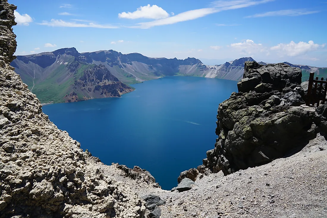
Paektu
Paektu Mountain, referred to as Changbai by the Chinese, is the highest mountain in both the Korean Peninsula and neighboring northeastern China. The mountain reaches 9,019 feet above Sea level. It was formed by a volcanic eruption that led to the formation of a large crater lake called Heaven Lake at the peak of the mountain. The weather around the mountain is unpredictable. The average annual temperature at the peak is -8.3 Degrees Celsius. During summer the temperature reaches 18 Degrees Celsius or higher, and during winter, it drops to up to −48 Degrees Celsius. Both Koreans and Manchus believe that it is their place of ancestral origin and continue to worship on the mountains. It is a common tourist destination for foreign visitors who tour monuments, springs, and ancient secret camps located on the mountain. The Heaven Lake is home to five known species of plants with others counted along its shores. The forest on the Chinese side of the mountain contains tree species like the birch, and pine. Animals like Siberian tigers, bears, wolves, and Amur leopards also inhabit the forests around the mountains. It supports birds like black grouse, woodpecker, and owls. The Chinese and the Koreans keep disputing over the ownership of the mountain as the Koreans consider it a full Korean territory and object to the use and developments of the mountain by the Chinese. The recent activities by the Chinese such as economic development, infrastructure, and cultural festivals spiked disagreements between the two communities.
Mantapsan
The mountain is located along the borders between the Kilju, Myongan, and Orang Counties of North Korea. It has a granite peak with an elevation of 7,234 feet making it the second highest mountain in the country. The mountain is a nuclear denotation site with many tunnels on the eastern side, dug by Korean prisoners for use in nuclear testing. It is where the nuclear tests of 2006, 2009, 2013, and 2016 took place. It also holds the largest North Korean concentration camp.
Myohyangsan
Myohyangsan Mountain is 6,263 feet high, and is the third highest mountain in North Korea. The natives named it Myohyangsan, meaning the "mysterious fragrant mountain", because of the mystic shapes and fragrances found in the area. The Koreans consider the mountain a sacred site and home to the legendary King Tangun who was the ancestor of the Korean people. The mountain is a tourist attraction site known for its hiking routes, Pohyon Temple, Sangwon Hermitage, Kumgang Hermitage, and Habiro Hermitage. UNESCO listed it as biosphere reserves in 2009 due to its cultural significance as a sacred place and home to the legend, and its spectacular cliff that is home to 30 endemic plant species, 12 endangered animal species and 16 globally threatened plant species.
Kumgangsan
Kumgangsan mountain rises to a height of 5 374 feet and is located along the eastern coast of North Korea. It consists of granite and diorite rocks weathered into a variety of shapes forming over 12,000 picturesque stone formations, ravines, cliffs, and peaks. It has three divisions, including Inner Kumgangsan with its spectacular views, Outer Kumgangsan with its many peaks, and Sea Kumgangsan which is noted for its lagoons and stone pillars. Much of the mountain consists of mixed broad-leaf and coniferous forest protected in a national park. It is also a major international bird area because of its endangered red-crowned cranes. Due to its scenic beauty, the mountain is a tourist destination, hosting various tourist nationalities. The natives paid homage to the mountain during the reign of the Joseon Dynasty.
Other Major Mountains in North Korea
Other mountains marking the topography of North Korea include Maeponsan with an elevation of 5,177 feet above sea level, the three Oposang Mountains with respective summit heights of 4,229 feet, 4,147 feet, and 3,870 feet, and Kuwolsan Mountain at 3,130 feet in elevation. The mountains have economic and cultural importance to the locals of North Korea, some serving as religious places and tourist attractions and others contain forests harvested by the natives. Most of the mountains are home to wide range of biodiversity, hosting some of the rare and endangered plants and animal species as well as endemic species.
Highest Mountains In North Korea
| Rank | Highest Mountains in North Korea | Elevation |
| 1 | Paektu | 9,019 feet |
| 2 | Mantapsan | 7,234 feet |
| 3 | Myohyangsan | 6,263 feet |
| 4 | Mataesan | 5,725 feet |
| 5 | Kumgangsan | 5,374 feet |
| 6 | Maepongsan | 5,177 feet |
| 7 | Opongsan | 4,229 feet |
| 8 | Opongsan | 4,147 feet |
| 9 | Opongsan | 3,870 feet |
| 10 | Kuwŏlsan | 3,130 feet |


