El Malpais National Monument - Unique Places in North America
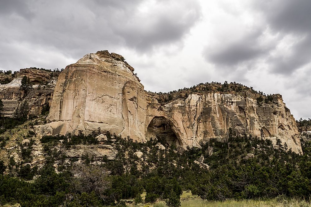
El Malpais National Monument is located in the southwestern part of the US in the western part of New Mexico. The name Malpais is derived from the Spanish word meaning badlands. It was named so because of the volcanic activity, rough terrain, dry rocky surface and general barrenness of the area. The national monument was established in November 1987 by President Reagan.
Description
The El Malpais National Monument is a region of approximately 114,276 acres. It was established on December 31, 1987, by the then President of the US, Ronald Reagan. The National Park Service currently manages the facility. As part of the monument, Zuni-Bandera volcanic field is one of the most recognizable features. The rock is estimated to be around 3.8 million years, with its last eruption slated to have occurred around 1170 BCE (give or take 300 years). Zuni-Bandera is 8,366 ft in elevation above sea level. The Malpais has recognizable volcanic formations on the surface from lava flows.
Habitat
Although El Malpais has a harsh environment and rugged lava landscape, there are different species of wildlife ranging from the smallest crustaceans like the shrimps to the largest mammals like the black bear, the elk, and the cougar. There are abundant bird species varying from the largest the Golden eagle to the smallest like the hummingbird. There are also reptiles, insects, amphibians, and arthropods. Lava tube caves around El Malpais have been inhabited by bats. Along the margins of lava flow are and particularly on the lower elevations are home to bunch grass, communities of wildflower, and shrubs. The hillslopes are dominated by the Pinion juniper and ponderosa pine, and other conifer species. The region is also home to the oldest subspecies of the Rocky Mountain Douglas-fir tree.
Uniqueness
Panoramic views overlooking Sandstone and the monument’s lava flows are considered spectacular. To the west, vents such as El Calderon and Bandera Crater among others follow the distribution of a north-south pattern. The Zuni-Bandera volcanic eruptions created the Pahoehoe and ʻAʻā lava flows that flowed into a large basin of rock.
Tourism
Visitors are often intrigued by the lava tube caves that they can visit unguided with a caving permit from NPS-staffed facilities issued for free. The US National Park Service has two visitor centers with maps, helpful detailed literature, historical displays, and staff with knowledge regarding the monument. Large areas of the nature conservation, wildlife, and natural habitats are protected within the Cibola National Forest. More than 100,000 visitors had been to the monument by 2011.
Threats
The monument is a region of planar fracture attributed to the Rio Grande Rift Basin and the 372.823 miles long Jemez Lineament. These features provide for volcanic features from the Zuni-Bandera volcanic field along with cinder cones and lava flows. The region is susceptible to earthquakes and volcanic activities since there is a weakness in the crust and there are magma interferences and volcanic disturbances. The region was also used to test early nuclear bombs, thus the presence of nuclear radiation in affected regions. WWII soldiers also used the area as a bombing range for the fighter pilots. The terrain is exceptionally rough making it hard to grow crops, and this can be attributed to sinkholes, collapsed tubes, and jagged surfaces.