What is Subsidence?
Subsidence is the downward motion of ground surface in relation to an entity like the sea level. In other words it can be described as the downward shift of the ground surface. Subsidence is an occurrence that affects residents, geologists, business owners, surveyors, and geotechnical engineers.
Subsidence is brought about by both natural occurrences and man made conditions. Human related processes that would bring about subsidence include mining, removal of natural gas, and overusing of ground water. The natural processes that cause subsidence include earthquakes, movement of ground water reservoirs, erosion, and soil compaction, among many others. The effects of subsidence can be seen in large areas like a state or a whole province, or it can occur in small areas like the corner of your kitchen garden.
The Dissolution of Limestone
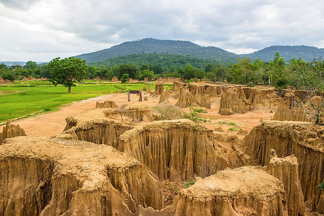
Subsidence is very common in areas that are formed with soluble rocks such as gypsum and limestone. These terrains are referred to as karst. The mentioned rocks dissolve leaving behind voids. The roofs to these voids weaken with time thus collapsing. To fill up the left space the rocks, or earth on top of the void roofs will also fall leaving an uneven ground surface due to the displacement. Subsidence by dissolution brings about the creation of sinkholes.
Mining
Mining methods that require the digging of tunnels in the ground to reach minerals (subsurface mining) is what causes subsidence. These mining methods employ processes like fracking, pillar extraction, the different types of caving and longwall mining thus causing the collapse of the surface on top. Subsidence caused by mining can be predicted in terms of the strength and extent of damage except when a pillar collapses or a tunnel close to the surface falls in. This mostly occurs in very old mines. The manifestation extent to such subsidence is only in the immediate locality of the mines plus a very small area around it.
Subsidence because of mining can be easily combated when all stakeholders work together. This can be achieved by careful planning of the mining process, taking preventive measures on foreseen weak points and repairing of mines after the mining is complete.
Extraction of Natural Gas
An unmined natural gas field possesses pressure of up to 60 MPa (600 bar). The pressure drops over the years as mining continues. The presence of the gas pressure also means that the layers of soil above the gas voids are well supported. The pressure in the fields reduce due to extraction, meaning that the pressure caused by carrying the overbearing soil surfaces becomes unbearable. If this occurs, then subsidence is inevitable.
A good example would be the Slochterengas field in the Netherlands. Mining started in this area in the late 1960s. Since then, due to the reduction of pressure under the ground surface, the ground surface level has reduced by 30cm. The extent of the subsidence has been experienced over an area of 250 km².
Earthquakes
Earthquakes have been known to cause subsidence of the ground surface. When earthquakes occur, fractures are created that mark the lines along which the crust moved. These fractures are called faults. Subsidence as a result of earthquakes can be caused by downward vertical movement of one side of a fault. Depending on the length of the fault, the subsidence can affect very large surface areas. Subsidence would also occur due to the effects of ground shaking. The shaking causes the loose particles to settle and loose the strength they had in bearing the particles on top of them.
The Geospatial Information Authority of Japan noticed and reported subsidence immediately after the 2011 Tōhoku earthquake. A subsidence of 0.50 m (1.64 ft) was noted in Northern Japan in areas close to the coast of the Pacific Ocean . The maximum subsidence caused by the Tōhoku earthquake was 1.2 m (3.93 ft) coupled with the deformation of earth’s crust of up to 5.3 m (17.3 ft)
Groundwater-Related Subsidence
Ground water, which is the main source of water on Earth, is stored in container like structures which as a whole looks like a very big sponge. As humans continue using water from these reservoirs, rain water replaces the used bit. If water is used too fast, as compared to the replacement rate by rain, then the ground above the reservoir could collapse to fill in the space left behind by water.
Another contributing factor is the occupation of lowlands and coastal plains that need drainage before habitation. Drainage of the soils exposes the soil components to oxidation and decomposition as a result. The decomposed organic matter becomes very weak and not able to withhold any weight, thus leading to subsidence.
Additionally these drained soils consolidate due to the force caused by its own effective stress. As the water is drained out of the soil, more soil particles compact together due to effective stress.
This kind of subsidence can be managed if factors such as crop optimization are put into consideration. The inhabitation of low land, swampy places or the coastal areas should also be regulated by relevant authorities.
Faulting and Folds Induced Subsidence
Folds are bumps in the rocks that occur due to compression forces, while faults are cracks that occur on rocks due to opposing stress. The geological definition of faults is a fracture or discontinuity in a volume of earth rock upon which there has been immense displacement caused by rock mass movement. When different stresses occur in the core of the earth, this pressure is either accommodated by the occurrence of faults, or by the formation of tunnels that offer movement for the hot fluid mantle.
There are different types of faults namely normal, reverse, and strike-slip faults. The difference is that the type of fault will determine the direction of the earth shift. Normal faults have been known to displace one side of the rock upwards while the other side falls downwards. What is seen on the ground surface is the split of the earth above the cracks will split in two directions.
Faults and folds develop over thousands of years, meaning that this kind of subsidence may not even be experienced in a generation’s lifespan.
Isostatic Subsidence
The earth’s surface floats in the asthenosphere balancing the mass below its surface and its own density with that of the asthenosphere. In case mass is added on the surface of the crust, it subsides in the asthenosphere to some level in order to keep the isostatic balance. The mass addition on Earth’s crust is caused by deposition a process where rocks, sediments, and soils are added on land.
The opposite of isostatic subsidence occurs when mass is reduced from the earth’s crust. This process called the isostatic rebound occurs when the crust surface rebounds to its normal state of isostasy. The process occurs over thousands of years, such that if we saw the effects today, it would mean the process started more than a century ago.
Isostatic rebound is caused by occurrences like melting of ice sheets or drying up of water masses.
Lake Bonnevile is a perfect example of an isostatic rebound. The amount of water that the ocean once held led to the subsidence of the lake to close to 200 feet (61 m) below sea level. This is a natural balancing effect so as to maintain equilibrium. When the water dried up, the surface rebounded, this is to say that the middle of the lake is 200 feet (61 m) taller than the former banks of the lake
Seasonal Effects
Clay is found almost all kinds of soils in most places. Clay has been known to be a very controversial type of soil. Due to its small particle sizes, they are highly affected by the moisture content in the soil. Due to the change of seasons, when it is hot and dry, water evaporates from the soil particles leading to a reduction in volume of the mass of soil. This then leads to the lowering of the soil surface. Any buildings that are built on top of soils are affected by seasonal drying face destruction to their foundations. The presence of tapering cracks on buildings in most cases is as a result of seasonal drying.
Vegetation and trees can also lead to the opposite of subsidence, a process called swelling or soil heaving.
How to Measure Subsidence
The National Oceanic and Atmospheric Administration (NOAA) has come up with a way of measuring subsidence through the use of the Global Positioning System (GPS). For this particular reason, NOAA has a body called the National Geodetic Survey that has put in place highly receptive GPS networks that keep track of the surface levels of different locations. These GPS networks are referred to as Continuously Operating Reference Station (CORS). Some areas do not have the CORS and in such cases a technology that works with the satellite called the InSAR (Interferometric Synthetic Aperature Radar) can be used to track subsidence. Ground water sensors are also a precise method of measuring and keeping track of ground surface height.